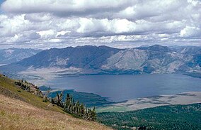
Henrys Lake State Park
| Henrys Lake State Park | |
|---|---|
 Henrys Lake | |
| Location | Fremont County, Idaho, United States |
| Nearest city | Island Park, Idaho |
| Coordinates | 44°37′12″N 111°22′26″W / 44.62000°N 111.37389°W[1] |
| Area | 585 acres (237 ha)[2] |
| Elevation | 6,470 ft (1,970 m)[2] |
| Designation | Idaho state park |
| Established | 1973[3] |
| Administrator | Idaho Department of Parks and Recreation |
| Website | Henrys Lake State Park |
Henrys Lake State Park is a public recreation area located on the south shore on Henrys Lake thirteen miles (21 km) north of Island Park in Fremont County, Idaho, U.S. The state park occupies 585 acres (237 ha) off US 20 near Goose Bay and the Henrys Lake Outlet. Park facilities include hiking trails, boat ramp, campgrounds, and cabins.[2] It is home to cutthroat trout, cutbow, moose, pronghorn, swans, pelicans, various waterfowl and sandhill cranes.
See also[edit]
References[edit]
- ^ "Henrys Lake State Park". Geographic Names Information System. United States Geological Survey, United States Department of the Interior.
- ^ a b c "Henrys Lake State Park". Idaho Parks and Recreation. Retrieved September 1, 2017.
- ^ "History: State Lands in Idaho". Idaho Museum of Natural History. Retrieved October 10, 2018.
External links[edit]
Wikimedia Commons has media related to Henrys Lake.
- Henrys Lake State Park Idaho Parks and Recreation
- Henrys Lake State Park Map Idaho Parks and Recreation


