
Huangtu Town
Huangtu Town | |
|---|---|
| 璜土镇 | |
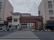
 View of Huangtu Town | |
 Huangtu Town | |
| Coordinates: 31°52′29″N 120°02′14″E / 31.87472°N 120.03722°E | |
| Country | |
| Province | Jiangsu |
| City | Wuxi |
| County-level city | Jiangyin |
| Elevation | 5 m (16 ft) |
| Population (2010) | |
| • Total | 74,116[1] |
| Time zone | UTC+8 |
| Geocode | 1807186 |
Huangtu Town (Chinese: 璜土镇) is a township-level administrative unit under the jurisdiction of Jiangyin, Wuxi, Jiangsu Province, the People's Republic of China.[2] It is located in the province of Jiangsu, in the eastern part of the country, about 120 kilometres (75 mi) east of the provincial capital, Nanjing. The number of inhabitants is 74,116.[1] The population consists of 35,388 women and 38,728 men. Children under 15 make up 10%, adults 15-64 make up 79%, and seniors over 65 make up 9%.[1]
Geography and climate[edit]
Around Huangtu it is very densely populated, with 2,103 inhabitants per square kilometer.[3] The nearest larger community is Changzhou, 13.9 kilometres (8.6 mi) southwest of Huangtu. The area around Huangtu consists mostly of agricultural land.[4]
Huangtu has a humid subtropical climate (Köppen: Cfa) with hot and wet summers and cold and humid winters. Average annual rainfall is 1,390 millimetres (55 in). The wettest month is July, with an average of 250 millimetres (9.8 in) of precipitation, and the driest is January, with 38 millimetres (1.5 in) of precipitation.[5]
| Climate data for Huangtu | |||||||||||||
|---|---|---|---|---|---|---|---|---|---|---|---|---|---|
| Month | Jan | Feb | Mar | Apr | May | Jun | Jul | Aug | Sep | Oct | Nov | Dec | Year |
| Record high °F (°C) | 69 (21) |
82 (28) |
84 (29) |
93 (34) |
97 (36) |
100 (38) |
102 (39) |
101 (38) |
103 (39) |
91 (33) |
82 (28) |
71 (22) |
103 (39) |
| Mean daily maximum °F (°C) | 44.6 (7.0) |
49.8 (9.9) |
55.5 (13.1) |
64.2 (17.9) |
77.1 (25.1) |
85.3 (29.6) |
87.1 (30.6) |
87.2 (30.7) |
80.6 (27.0) |
71.7 (22.1) |
59.8 (15.4) |
50.5 (10.3) |
67.8 (19.9) |
| Daily mean °F (°C) | 39.1 (3.9) |
42.8 (6.0) |
48.8 (9.3) |
58.4 (14.7) |
70.1 (21.2) |
79.0 (26.1) |
82.3 (27.9) |
82.2 (27.9) |
75.0 (23.9) |
65.1 (18.4) |
54.4 (12.4) |
44.1 (6.7) |
61.8 (16.5) |
| Mean daily minimum °F (°C) | 33.6 (0.9) |
35.7 (2.1) |
42.1 (5.6) |
52.6 (11.4) |
63.1 (17.3) |
72.7 (22.6) |
77.5 (25.3) |
77.1 (25.1) |
69.3 (20.7) |
58.5 (14.7) |
49.0 (9.4) |
37.7 (3.2) |
55.7 (13.2) |
| Record low °F (°C) | 11 (−12) |
13 (−11) |
21 (−6) |
33 (1) |
47 (8) |
58 (14) |
65 (18) |
64 (18) |
53 (12) |
37 (3) |
19 (−7) |
−1 (−18) |
−1 (−18) |
| Average precipitation inches (mm) | 1.50 (38) |
4.80 (122) |
3.60 (91) |
4.30 (109) |
5.30 (135) |
5.40 (137) |
9.80 (249) |
7.80 (198) |
3.50 (89) |
4.00 (102) |
2.40 (61) |
2.10 (53) |
54.5 (1,384) |
| Source: NASA[5] | |||||||||||||
Gallery[edit]
-
 Welcome sign for Huangtu Town
 -
 Primary school
 -
 Kindergarten
 -
 Huangcun Village


See also[edit]
References[edit]
- ^ a b c National Bureau of Statistics of China (2012). Feng Nailin (冯乃林) (ed.). 中国2010年人口普查分乡、镇、街道资料. Chinese Statistics. ISBN 9787503766602.
- ^ Huangtu Town in Geonames.org (cc-by)
- ^ "NASA Earth Observations: Population Density". NASA/SEDAC. 2016-01-30. Archived from the original on 2016-02-09.
- ^ "NASA Earth Observations: Land Cover Classification". NASA/MODIS. 2016-01-30. Archived from the original on 2016-02-28.
- ^ a b "NASA Earth Observations: Rainfall (1 month - TRMM)". NASA/Tropical Rainfall Monitoring Mission. 2016-01-30. Archived from the original on 2020-05-11.