
Huntsville, Utah
Huntsville, Utah
Anga-we-ya-dye | |
|---|---|
 The eastern part of Huntsville | |
| Nickname: McKayville | |
 Location in Weber County and the state of Utah | |
| Coordinates: 41°15′36″N 111°46′24″W / 41.26000°N 111.77333°W | |
| Country | United States |
| State | Utah |
| County | Weber |
| Founded | 1860 |
| Incorporated | 1924 |
| Founded by | Jefferson Hunt |
| Area | |
| • Total | 0.89 sq mi (2.30 km2) |
| • Land | 0.83 sq mi (2.15 km2) |
| • Water | 0.06 sq mi (0.15 km2) |
| Elevation | 4,928 ft (1,502 m) |
| Population (2010) | |
| • Total | 608 |
| • Estimate (2019)[3] | 642 |
| • Density | 774.43/sq mi (299.13/km2) |
| Time zone | UTC-7 (Mountain (MST)) |
| • Summer (DST) | UTC-6 (MDT) |
| ZIP code | 84317 |
| Area code(s) | 385, 801 |
| FIPS code | 49-37060[4] |
| GNIS feature ID | 1428949[2] |
| Website | www |
Huntsville (Shoshone: Anga-we-ya-dye) is a town in Weber County, Utah, United States. The population was 608 at the 2010 census. It is located in Ogden Valley. It is part of the Ogden–Clearfield, Utah Metropolitan Statistical Area, as well as the Ogden Valley census county division.
History[edit]
The Western Shoshone were some of the first inhabitants of the area. They called the area Anga-we-ya-dye, meaning “Where the red berries grow”[5]
Huntsville was founded in 1860 by Jefferson Hunt.[6] An LDS ward was organized there in 1877 with Francis Hammond as Bishop, and he was succeeded in 1885 by David McKay. This David McKay was the father of David O. McKay, later president of the Church of Jesus Christ of Latter-day Saints.[7] A Trappist monastery, the Abbey of Our Lady of the Holy Trinity, was established there in 1947, and closed after 70 years in 2017. The Shooting Star Saloon, the oldest continuously operating bar west of the Mississippi, is located in the town.[8][9] It opened in 1879. It is known for the off-menu Star Burger: two patties with cheese, Polish knackwurst, and bacon.[10]
Geography[edit]
According to the United States Census Bureau, the town has a total area of 0.7 square miles (1.9 km2), of which 0.6 square mile (1.7 km2) is land and 0.1 square mile (0.2 km2) (9.46%) is water.
Climate[edit]
This climatic region is typified by large seasonal temperature differences, with warm to hot (and often humid) summers and cold (sometimes severely cold) winters. According to the Köppen Climate Classification system, Huntsville has a humid continental climate, abbreviated "Dfb" on climate maps.[11]
| Climate data for Huntsville, Utah, 1991–2020 normals, 1976-2020 extremes: 5140ft (1567m) | |||||||||||||
|---|---|---|---|---|---|---|---|---|---|---|---|---|---|
| Month | Jan | Feb | Mar | Apr | May | Jun | Jul | Aug | Sep | Oct | Nov | Dec | Year |
| Record high °F (°C) | 57 (14) |
62 (17) |
77 (25) |
86 (30) |
93 (34) |
97 (36) |
102 (39) |
102 (39) |
95 (35) |
88 (31) |
73 (23) |
64 (18) |
102 (39) |
| Mean maximum °F (°C) | 48.5 (9.2) |
52.3 (11.3) |
65.3 (18.5) |
76.4 (24.7) |
84.6 (29.2) |
92.7 (33.7) |
96.6 (35.9) |
95.5 (35.3) |
89.5 (31.9) |
80.6 (27.0) |
64.1 (17.8) |
50.3 (10.2) |
97.4 (36.3) |
| Mean daily maximum °F (°C) | 34.2 (1.2) |
40.7 (4.8) |
51.2 (10.7) |
60.3 (15.7) |
71.3 (21.8) |
81.9 (27.7) |
90.1 (32.3) |
89.1 (31.7) |
79.2 (26.2) |
64.3 (17.9) |
47.7 (8.7) |
35.0 (1.7) |
62.1 (16.7) |
| Daily mean °F (°C) | 22.6 (−5.2) |
27.8 (−2.3) |
37.6 (3.1) |
45.5 (7.5) |
54.2 (12.3) |
62.2 (16.8) |
69.5 (20.8) |
68.2 (20.1) |
59.3 (15.2) |
47.2 (8.4) |
34.8 (1.6) |
23.8 (−4.6) |
46.1 (7.8) |
| Mean daily minimum °F (°C) | 10.9 (−11.7) |
14.9 (−9.5) |
24.0 (−4.4) |
30.7 (−0.7) |
37.2 (2.9) |
42.6 (5.9) |
48.9 (9.4) |
47.3 (8.5) |
39.3 (4.1) |
30.2 (−1.0) |
22.0 (−5.6) |
12.7 (−10.7) |
30.1 (−1.1) |
| Mean minimum °F (°C) | −9.6 (−23.1) |
−8.2 (−22.3) |
4.1 (−15.5) |
16.7 (−8.5) |
23.7 (−4.6) |
30.5 (−0.8) |
38.4 (3.6) |
36.0 (2.2) |
26.0 (−3.3) |
16.3 (−8.7) |
0.4 (−17.6) |
−7.4 (−21.9) |
−15.1 (−26.2) |
| Record low °F (°C) | −33 (−36) |
−34 (−37) |
−17 (−27) |
0 (−18) |
16 (−9) |
24 (−4) |
31 (−1) |
23 (−5) |
18 (−8) |
9 (−13) |
−16 (−27) |
−37 (−38) |
−37 (−38) |
| Average precipitation inches (mm) | 2.76 (70) |
2.19 (56) |
2.00 (51) |
1.90 (48) |
2.14 (54) |
1.34 (34) |
0.69 (18) |
0.78 (20) |
1.31 (33) |
1.79 (45) |
1.80 (46) |
2.44 (62) |
21.14 (537) |
| Average snowfall inches (cm) | 22.50 (57.2) |
17.40 (44.2) |
7.20 (18.3) |
3.10 (7.9) |
0.30 (0.76) |
0.00 (0.00) |
0.00 (0.00) |
0.00 (0.00) |
0.00 (0.00) |
1.80 (4.6) |
7.30 (18.5) |
22.80 (57.9) |
82.4 (209.36) |
| Source 1: NOAA[12] | |||||||||||||
| Source 2: XMACIS2 (records & monthly max/mins)[13] | |||||||||||||
Demographics[edit]
| Census | Pop. | Note | %± |
|---|---|---|---|
| 1870 | 1,051 | — | |
| 1880 | 819 | −22.1% | |
| 1890 | 1,158 | 41.4% | |
| 1900 | 1,022 | −11.7% | |
| 1910 | 906 | −11.4% | |
| 1920 | 814 | −10.2% | |
| 1930 | 520 | −36.1% | |
| 1940 | 496 | −4.6% | |
| 1950 | 494 | −0.4% | |
| 1960 | 552 | 11.7% | |
| 1970 | 553 | 0.2% | |
| 1980 | 577 | 4.3% | |
| 1990 | 561 | −2.8% | |
| 2000 | 649 | 15.7% | |
| 2010 | 608 | −6.3% | |
| 2019 (est.) | 642 | [3] | 5.6% |
| U.S. Decennial Census[14] | |||
As of the census[4] of 2000, there were 649 people, 194 households, and 163 families residing in the town. The population density was 965.3 people per square mile (374.0/km2). There were 219 housing units at an average density of 325.7 per square mile (126.2/km2). The racial makeup of the town was 98.77% White, 0.15% African American, 0.31% Native American, 0.15% from other races, and 0.62% from two or more races. Hispanic or Latino of any race were 3.08% of the population.
There were 194 households, out of which 46.4% had children under the age of 18 living with them, 70.6% were married couples living together, 10.3% had a female householder with no husband present, and 15.5% were non-families. 13.4% of all households were made up of individuals, and 7.7% had someone living alone who was 65 years of age or older. The average household size was 3.35 and the average family size was 3.70.
In the town, the population was spread out, with 33.7% under the age of 18, 11.1% from 18 to 24, 21.4% from 25 to 44, 21.9% from 45 to 64, and 11.9% who were 65 years of age or older. The median age was 34 years. For every 100 females, there were 108.7 males. For every 100 females age 18 and over, there were 102.8 males.
The median income for a household in the town was $50,625, and the median income for a family was $52,656. Males had a median income of $37,411 versus $31,528 for females. The per capita income for the town was $16,232. About 4.3% of families and 5.9% of the population were below the poverty line, including 5.1% of those under age 18 and 7.6% of those age 65 or over.
Gallery[edit]
-
 Abbey Road of the former monastery in Huntsville Utah
 -
 Aldous Cabin Huntsville Utah
 -
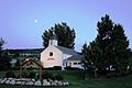 Saint Florence Catholic Church - Huntsville, Utah
 -
 Snowbasin Ski Area from Huntsville Utah
 -
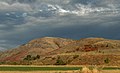 Fall clouds - Huntsville, Utah
 -
 Fall leaves - Huntsville, Utah
 -
 Fall colors - Huntsville, Utah
 -
 Cloud - Huntsville, Utah
 -
 Pineview Dam


Federal representation[edit]
Huntsville is located in Utah's First Congressional District. For the 117th United States Congress, this district is represented by Blake Moore (R-Ogden)[15]
See also[edit]
References[edit]
- ^ "2019 U.S. Gazetteer Files". United States Census Bureau. Retrieved August 7, 2020.
- ^ a b U.S. Geological Survey Geographic Names Information System: Huntsville, Utah
- ^ a b "Population and Housing Unit Estimates". United States Census Bureau. May 24, 2020. Retrieved May 27, 2020.
- ^ a b "U.S. Census website". United States Census Bureau. Retrieved January 31, 2008.
- ^ "ArcGIS Web Application". mlibgisservices.maps.arcgis.com. Retrieved March 23, 2023.
- ^ The Utah Genealogical and Historical Magazine, Volumes 9-10. 1918. p. 188.
- ^ Andrew Jenson. Encyclopedic History of the Church'. (Salt Lake City: Deseret News Press, 1941) p. 347
- ^ "Utah's oldest saloon haunted by its history". January 15, 1999.
- ^ https://www.standard.net/news/local/utahs-shooting-star-saloon-frozen-in-time/article_4b72d513-cb95-5249-96b0-b287e3b253b4.html [dead link]
- ^ Entwistle, Sarah (March 7, 2022). "The 28 Essential Salt Lake City Restaurants". Eater. Retrieved February 20, 2023.
- ^ Climate Summary for Huntsville, Utah
- ^ "Huntsville Monastery, Utah 1991-2020 Monthly Normals". Retrieved November 19, 2023.
- ^ "xmACIS". National Oceanic and Atmospheric Administration. Retrieved November 15, 2023.
- ^ "Census of Population and Housing". Census.gov. Retrieved June 4, 2015.
- ^ "Representatives | house.gov".
External links[edit]
Places adjacent to Huntsville, Utah | |
|---|---|
Municipalities and communities of Weber County, Utah, United States | ||
|---|---|---|
| Cities | 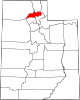 | |
| Town | ||
| Townships | ||
| CDPs | ||
| Unincorporated communities | ||
| International | |
|---|---|
| National | |