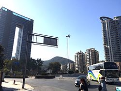
Jiande
Jiande
建德市 Kienteh | |
|---|---|
 | |
| Coordinates: 29°29′23″N 119°20′13″E / 29.4896°N 119.337°E | |
| Country | People's Republic of China |
| Province | Zhejiang |
| Sub-provincial city | Hangzhou |
| Time zone | UTC+8 (China Standard) |
| Postal code | 311600 |
Jiande ⓘ is a county-level city of Zhejiang Province, East China, it is under the administration of the prefecture-level city of Hangzhou.
History[edit]
During the Ming and Qing Dynasties, Jiande was the capital of Yanzhou Prefecture. On account of this, Jiande was often referred to as Yanzhou Fu (严州府). A transcription commonly seen in both French and English writing of the time was Yen-tcheou-fou, derived from French missionary writing.[1][2][3]
Administrative divisions[edit]
Subdistricts:[4]
- Yangxi Subdistrict (洋溪街道), Genglou Subdistrict (更楼街道), Xin'anjiang Subdistrict (新安江街道)
Towns:
- Meicheng (梅城镇), Xiaya (下涯镇), Yangcunqiao (杨村桥镇), Qiantan (乾潭镇), Sandu (三都镇), Shouchang (寿昌镇), Datong (大同镇), Hangtou (航头镇), Lijia (李家镇), Dayang (大洋镇), Lianhua (莲花镇), Daciyan (大慈岩镇)
The only township is Qintang Township (钦堂乡)
Climate[edit]
| Climate data for Jiande (1991–2020 normals, extremes 1981–2010) | |||||||||||||
|---|---|---|---|---|---|---|---|---|---|---|---|---|---|
| Month | Jan | Feb | Mar | Apr | May | Jun | Jul | Aug | Sep | Oct | Nov | Dec | Year |
| Record high °C (°F) | 25.0 (77.0) |
28.7 (83.7) |
34.0 (93.2) |
36.0 (96.8) |
36.9 (98.4) |
37.9 (100.2) |
42.4 (108.3) |
41.9 (107.4) |
40.0 (104.0) |
37.5 (99.5) |
31.7 (89.1) |
25.0 (77.0) |
42.4 (108.3) |
| Mean daily maximum °C (°F) | 9.9 (49.8) |
12.6 (54.7) |
17.0 (62.6) |
23.1 (73.6) |
27.6 (81.7) |
29.6 (85.3) |
34.4 (93.9) |
34.1 (93.4) |
29.7 (85.5) |
24.7 (76.5) |
18.8 (65.8) |
12.6 (54.7) |
22.8 (73.1) |
| Daily mean °C (°F) | 5.3 (41.5) |
7.3 (45.1) |
11.2 (52.2) |
16.8 (62.2) |
21.6 (70.9) |
24.5 (76.1) |
28.4 (83.1) |
28.1 (82.6) |
24.1 (75.4) |
18.9 (66.0) |
13.1 (55.6) |
7.4 (45.3) |
17.2 (63.0) |
| Mean daily minimum °C (°F) | 2.3 (36.1) |
3.9 (39.0) |
7.4 (45.3) |
12.5 (54.5) |
17.3 (63.1) |
21.1 (70.0) |
24.2 (75.6) |
24.1 (75.4) |
20.3 (68.5) |
14.8 (58.6) |
9.4 (48.9) |
3.9 (39.0) |
13.4 (56.2) |
| Record low °C (°F) | −6.3 (20.7) |
−6.2 (20.8) |
−3.4 (25.9) |
1.1 (34.0) |
8.5 (47.3) |
12.3 (54.1) |
18.2 (64.8) |
18.3 (64.9) |
10.4 (50.7) |
3.4 (38.1) |
−1.6 (29.1) |
−8.0 (17.6) |
−8.0 (17.6) |
| Average precipitation mm (inches) | 91.3 (3.59) |
100.8 (3.97) |
165.4 (6.51) |
179.5 (7.07) |
192.7 (7.59) |
319.2 (12.57) |
163.2 (6.43) |
155.5 (6.12) |
98.2 (3.87) |
52.4 (2.06) |
78.5 (3.09) |
66.4 (2.61) |
1,663.1 (65.48) |
| Average precipitation days (≥ 0.1 mm) | 13.8 | 13.1 | 16.9 | 15.7 | 15.8 | 17.8 | 12.1 | 13.6 | 9.9 | 7.8 | 10.8 | 10.6 | 157.9 |
| Average snowy days | 3.6 | 2.7 | 0.6 | 0 | 0 | 0 | 0 | 0 | 0 | 0 | 0.1 | 1.4 | 8.4 |
| Average relative humidity (%) | 78 | 78 | 78 | 77 | 77 | 83 | 78 | 78 | 78 | 76 | 79 | 77 | 78 |
| Mean monthly sunshine hours | 95.4 | 95.8 | 118.0 | 138.3 | 156.7 | 125.6 | 217.5 | 208.3 | 163.1 | 159.6 | 122.9 | 115.8 | 1,717 |
| Percent possible sunshine | 29 | 30 | 32 | 36 | 37 | 30 | 51 | 51 | 44 | 45 | 39 | 36 | 38 |
| Source: China Meteorological Administration[5][6] | |||||||||||||
Transportation[edit]
Direct trains for freight link Jiande with Yiwu and Jinhua. There is also a high-speed rail station.
See also[edit]
- Xinye Village, a village in Jiande
Notes[edit]
Wikimedia Commons has media related to Jiande.
- ^ An historical, geographical, and philosophical view of the Chinese empire: comprehending a description of the fifteen provinces of China, Chinese Tartary; tributary states; natural history of China; government, religion, laws, manners and customs, literature, arts, sciences, manufactures, &c (2 ed.). p. 83.
- ^ Murray, Hugh; Crawfurd, John; Gordon, Peter (1843), An historical and descriptive account of China: its ancient and modern history, language, literature, religion, government, industry, manners, and social state ... (3 ed.), Oliver & Boyd, pp. 25–26
- ^ Yen-tcheou-fou was also used to transcribe the name of the city and prefecture in Shandong. (Both places' names are transcribed as "Yanzhou" in pinyin, but are written with different Chinese characters).
- ^ "杭州市-行政区划网 www.xzqh.org" (in Chinese). XZQH. Retrieved 2012-05-24.
- ^ 中国气象数据网 – WeatherBk Data (in Simplified Chinese). China Meteorological Administration. Retrieved 25 June 2023.
- ^ 中国气象数据网 (in Simplified Chinese). China Meteorological Administration. Retrieved 25 June 2023.

