
Liausson
Liausson | |
|---|---|
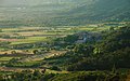
 A general view of Liausson | |
Location of Liausson  | |
 Liausson  Liausson | |
| Coordinates: 43°38′12″N 3°22′14″E / 43.6367°N 3.3706°E | |
| Country | France |
| Region | Occitania |
| Department | Hérault |
| Arrondissement | Lodève |
| Canton | Clermont-l'Hérault |
| Intercommunality | Clermontais |
| Government | |
| • Mayor (2020–2026) | Alain Soulayrol[1] |
| Area 1 | 7.95 km2 (3.07 sq mi) |
| Population (2021)[2] | 151 |
| • Density | 19/km2 (49/sq mi) |
| Time zone | UTC+01:00 (CET) |
| • Summer (DST) | UTC+02:00 (CEST) |
| INSEE/Postal code | 34137 /34800 |
| Elevation | 135–537 m (443–1,762 ft) (avg. 210 m or 690 ft) |
| 1 French Land Register data, which excludes lakes, ponds, glaciers > 1 km2 (0.386 sq mi or 247 acres) and river estuaries. | |
Liausson (French pronunciation: [ljosɔ̃]) is a commune in the Hérault département in the Occitanie region in southern France.

Population[edit]
| Year | Pop. | ±% |
|---|---|---|
| 1962 | 66 | — |
| 1968 | 89 | +34.8% |
| 1975 | 84 | −5.6% |
| 1982 | 99 | +17.9% |
| 1990 | 95 | −4.0% |
| 1999 | 110 | +15.8% |
| 2008 | 126 | +14.5% |
Sights[edit]
The church was built on the ruined foundations of a Roman villa
Gallery[edit]
-
 La mairie.
 -
 Le lavoir.
 -
 Dawn on the village.
 -
 "Montagne de Liausson" from Villeneuvette.


See also[edit]
References[edit]
- ^ "Répertoire national des élus: les maires". data.gouv.fr, Plateforme ouverte des données publiques françaises (in French). 2 December 2020.
- ^ "Populations légales 2021". The National Institute of Statistics and Economic Studies. 28 December 2023.
Wikimedia Commons has media related to Liausson.
| Authority control databases: National |
|---|
This Hérault geographical article is a stub. You can help Wikipedia by expanding it. |