Meredith, Colorado
Meredith, Colorado | |
|---|---|
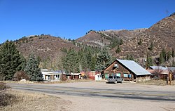
 A view of Meredith from across Frying Pan Road | |
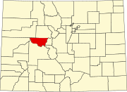
Location in Pitkin County and the state of Colorado | |
| Coordinates: 39°21′44″N 106°43′50″W / 39.36222°N 106.73056°W | |
| Country | |
| State | |
| County | Pitkin[1] |
| Elevation | 7,772 ft (2,369 m) |
| Time zone | UTC-7 (MST) |
| • Summer (DST) | UTC-6 (MDT) |
| ZIP code[2] | 81642 |
| GNIS feature ID | 0179732 |
Meredith is an unincorporated community and a U.S. Post Office in Pitkin County, Colorado, United States. The Meredith Post Office has the ZIP Code 81642.[2]
Meredith was a limestone quarry town as well as a lumber camp in the 1890s. It is now mainly a "resort area". There are many original occupied buildings.
Geography[edit]
Meredith is located at 39°21′44″N 106°43′50″W / 39.36222°N 106.73056°W (39.362174,-106.730633).
Climate[edit]
| Climate data for Meredith, Colorado, 1991–2020 normals: 7825ft (2385m) | |||||||||||||
|---|---|---|---|---|---|---|---|---|---|---|---|---|---|
| Month | Jan | Feb | Mar | Apr | May | Jun | Jul | Aug | Sep | Oct | Nov | Dec | Year |
| Record high °F (°C) | 58 (14) |
59 (15) |
65 (18) |
75 (24) |
89 (32) |
91 (33) |
98 (37) |
93 (34) |
90 (32) |
80 (27) |
68 (20) |
59 (15) |
98 (37) |
| Mean maximum °F (°C) | 48 (9) |
50 (10) |
56 (13) |
66 (19) |
76 (24) |
85 (29) |
89 (32) |
87 (31) |
83 (28) |
73 (23) |
60 (16) |
50 (10) |
92 (33) |
| Mean daily maximum °F (°C) | 34.1 (1.2) |
35.7 (2.1) |
42.9 (6.1) |
51.0 (10.6) |
62.9 (17.2) |
74.5 (23.6) |
81.1 (27.3) |
79.7 (26.5) |
71.2 (21.8) |
61.1 (16.2) |
44.6 (7.0) |
33.7 (0.9) |
56.0 (13.4) |
| Daily mean °F (°C) | 18.8 (−7.3) |
20.7 (−6.3) |
28.1 (−2.2) |
35.8 (2.1) |
45.6 (7.6) |
54.3 (12.4) |
60.4 (15.8) |
59.4 (15.2) |
51.6 (10.9) |
42.2 (5.7) |
28.9 (−1.7) |
19.2 (−7.1) |
38.7 (3.8) |
| Mean daily minimum °F (°C) | 3.5 (−15.8) |
5.7 (−14.6) |
13.2 (−10.4) |
20.6 (−6.3) |
28.4 (−2.0) |
34.1 (1.2) |
39.7 (4.3) |
39.1 (3.9) |
31.9 (−0.1) |
23.3 (−4.8) |
13.2 (−10.4) |
4.7 (−15.2) |
21.5 (−5.8) |
| Mean minimum °F (°C) | −17 (−27) |
−16 (−27) |
−7 (−22) |
7 (−14) |
17 (−8) |
25 (−4) |
31 (−1) |
31 (−1) |
21 (−6) |
11 (−12) |
−7 (−22) |
−15 (−26) |
−22 (−30) |
| Record low °F (°C) | −29 (−34) |
−38 (−39) |
−30 (−34) |
−7 (−22) |
6 (−14) |
17 (−8) |
23 (−5) |
23 (−5) |
12 (−11) |
−5 (−21) |
−21 (−29) |
−35 (−37) |
−38 (−39) |
| Average precipitation inches (mm) | 1.50 (38) |
1.57 (40) |
1.85 (47) |
2.15 (55) |
1.87 (47) |
1.05 (27) |
1.70 (43) |
1.65 (42) |
1.97 (50) |
1.71 (43) |
1.53 (39) |
1.15 (29) |
19.7 (500) |
| Average snowfall inches (cm) | 19.0 (48) |
14.6 (37) |
11.6 (29) |
7.7 (20) |
1.9 (4.8) |
0.0 (0.0) |
0.0 (0.0) |
0.0 (0.0) |
0.2 (0.51) |
3.4 (8.6) |
10.5 (27) |
19.1 (49) |
88 (223.91) |
| Source 1: NOAA[3] | |||||||||||||
| Source 2: XMACIS (records & monthly max/mins & Basalt precip/snowfall)[4] | |||||||||||||
See also[edit]
- Colorado
References[edit]
- ^ a b "US Board on Geographic Names". United States Geological Survey. October 25, 2007. Retrieved January 31, 2008.
- ^ a b "ZIP Code Lookup". United States Postal Service. January 2, 2007. Archived from the original (JavaScript/HTML) on January 1, 2008. Retrieved January 2, 2007.
- ^ "Meredith, Colorado 1991-2020 Monthly Normals". Retrieved November 3, 2023.
- ^ "xmACIS". National Oceanic and Atmospheric Administration. Retrieved November 3, 2023.
External links[edit]


