Mumford, New York
Mumford, Wheatland, New York | |
|---|---|
| Coordinates: 42°59′48.99″N 77°51′42.91″W / 42.9969417°N 77.8619194°W | |
| Country | United States |
| State | New York |
| County | Monroe |
| Town | Wheatland |
| Elevation | 617 ft (188 m) |
| Time zone | UTC-5 (EST) |
| • Summer (DST) | UTC-4 (EDT) |
| ZIP code | 14511 |
| Area code | 585 |
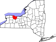
The hamlet of Mumford lies on the western side of the Town of Wheatland, Monroe County, New York, United States, south of Oatka Creek on NY 36 and south of the terminus of NY 383.
Arts and culture[edit]
The First Baptist Church of Mumford and First Presbyterian Church of Mumford are listed on the National Register of Historic Places.[1]
The Genesee Country Village & Museum[2] contains a model historic village preserving local architecture, a nature center, model gardens, and sporting art and carriage museums.
References[edit]
- ^ "National Register Information System". National Register of Historic Places. National Park Service. July 9, 2010.
- ^ "Directions to Genesee Country Village & Museum". Genesee Country Village & Museum. Retrieved June 26, 2010.
External links[edit]
- https://web.archive.org/web/20080929130254/http://www.rootsweb.ancestry.com/~nymonroe/vr/wheatland1869.htm - business directory from 1869

