
Puerto Rico Highway 633
Highway 633 | ||||
|---|---|---|---|---|
| Ruta 633 | ||||
| Route information | ||||
| Maintained by Puerto Rico DTPW | ||||
| Length | 4.3 km[1] (2.7 mi) | |||
| Existed | 1953[2]–present | |||
| Major junctions | ||||
| West end | ||||
| East end | ||||
| Location | ||||
| Country | United States | |||
| Territory | Puerto Rico | |||
| Municipalities | Ciales, Morovis | |||
| Highway system | ||||
| ||||
| ||||

Puerto Rico Highway 633 (PR-633) is an east–west rural road located between the municipalities of Ciales and Morovis in Puerto Rico.[3] With a length of 4.3 km (2.7 mi), it begins at its intersection with PR-149 in Hato Viejo barrio and ends at its junction with PR-155 in Barahona.[4]
Route description[edit]
Due to its rural characteristics, PR-633 consists of one lane per direction for its entire length. In Ciales, it extends from PR-149 intersection to the Morovis municipal limit, making its way through Hato Viejo barrio.[5] In Morovis, PR-633 extends to the east within Barahona barrio from the Ciales municipal limit until its eastern terminus at PR-155 junction.[6] In both municipalities, this highway serves as the main access to several neighborhoods and sectors between PR-149 and PR-155.
-
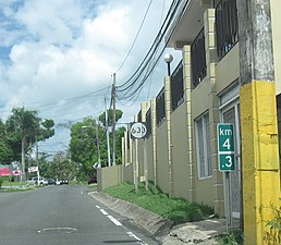 PR-633 west in Barahona, Morovis
 -
 Building on PR-633 in Barahona, Morovis
 -
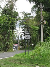 PR-155 north near PR-633 intersection in Barahona, Morovis


History[edit]
The entire length of PR-633 is part of the western section of the old Road No. 20, a highway that led from Naranjito to Ciales through Corozal and Morovis until the 1953 Puerto Rico highway renumbering, a process implemented by the Puerto Rico Department of Transportation and Public Works (Spanish: Departamento de Transportación y Obras Públicas) that increased the insular highway network to connect existing routes with different locations around Puerto Rico. Route 20 was divided into two segments: the first one, from Naranjito to Corozal, and the second one, from Corozal to Ciales.[7] The first section corresponds to the current PR-164 from PR-167 (old Road No. 9) to PR-159 (former Road No. 10),[8] while the second one went to Morovis through PR-159,[9] beginning at its junction with PR-568 (old Road No. 10) in western Corozal to continue to Ciales through PR-155, PR-633 and PR-6633 until its end at PR-6685 (former Road No. 11).[2]
Major intersections[edit]
| Municipality | Location | km[1] | mi | Destinations | Notes |
|---|---|---|---|---|---|
| Ciales | Hato Viejo | 0.0 | 0.0 | Western terminus of PR-633 | |
| Morovis | Barahona | 4.3 | 2.7 | Eastern terminus of PR-633 | |
| 1.000 mi = 1.609 km; 1.000 km = 0.621 mi | |||||
Related route[edit]
Highway 6633 | |
|---|---|
| Location | Ciales |
| Length | 0.22 km[10] (0.14 mi; 720 ft) |
Puerto Rico Highway 6633 (PR-6633) is a spur route located in Ciales. With a length of 0.22 km (0.14 mi), it extends from PR-6685 to PR-149, near to the western terminus of PR-633.[11] The entire route is located in Hato Viejo, Ciales.
-
 Western terminus of PR-6633 at PR-6685 junction in Hato Viejo, Ciales, looking east
 -
 PR-149 north near PR-6633 intersection
 -
 PR-149 north at PR-6633 intersection

.jpg)
.jpg)
| km[10] | mi | Destinations | Notes | ||
|---|---|---|---|---|---|
| 0.00 | 0.00 | Western terminus of PR-6633 | |||
| 0.22 | 0.14 | Eastern terminus of PR-6633 | |||
| 1.000 mi = 1.609 km; 1.000 km = 0.621 mi | |||||
See also[edit]
References[edit]
- ^ a b Google (28 February 2020). "PR-633" (Map). Google Maps. Google. Retrieved 28 February 2020.
- ^ a b "Morovis, Memoria Núm. 65" (PDF). Puerto Rico Planning Board (in Spanish). 1955. Retrieved 22 February 2020.
- ^ National Geographic Maps (2011). Puerto Rico (Map). 1:125,000. Adventure Map (Book 3107). Evergreen, Colorado: National Geographic Maps. ISBN 978-1566955188. OCLC 756511572.
- ^ "Tránsito Promedio Diario (AADT)". Transit Data (Datos de Transito) (in Spanish). DTOP PR. p. 117. Archived from the original on 1 April 2019.
- ^ "PR-633, Ciales, Puerto Rico". pr.geoview.info. Retrieved 22 February 2020.
- ^ "PR-633, Morovis, Puerto Rico". pr.geoview.info. Retrieved 22 February 2020.
- ^ "Revista de Obras Públicas de Puerto Rico, Febrero 1929". Colección Puertorriqueña UPR RP (in Spanish). 1929. pp. 22–23. Retrieved 10 August 2023.
- ^ "Naranjito, Memoria Núm. 53" (PDF). Puerto Rico Planning Board (in Spanish). 1955. Retrieved 10 August 2023.
- ^ "Corozal, Memoria Núm. 61" (PDF). Puerto Rico Planning Board (in Spanish). 1955. Retrieved 10 August 2023.
- ^ a b Google (22 March 2020). "PR-6633" (Map). Google Maps. Google. Retrieved 22 March 2020.
- ^ "Pr-6633, Ciales, Puerto Rico". pr.geoview.info. Retrieved 22 March 2020.
External links[edit]
 Media related to Puerto Rico Highway 633 and Puerto Rico Highway 6633 at Wikimedia Commons
- Guía de Carreteras Principales, Expresos y Autopistas (in Spanish)