
Río Grande de Arecibo
| Arecibo River | |
|---|---|
 Río Grande de Arecibo | |
| Etymology | After the town of Arecibo, itself named after the Taíno cacique Arasibo and/or Taíno "arasiba" possibly meaning 'people's stone'. |
| Native name | Río Grande de Arecibo (Spanish) |
| Location | |
| Commonwealth | Puerto Rico |
| Municipality | Arecibo, Utuado |
| Physical characteristics | |
| Source | |
| • location | Depending on the definition near Utuado Pueblo at the junction of the Viví and the Pellejas Rivers or Dos Bocas Lake between Arecibo and Utuado |
| • coordinates | 18°28′22″N 66°42′38″W / 18.47278°N 66.71056°W |
| Mouth | |
• location | Arecibo Bay in the Atlantic Ocean near Arecibo Pueblo |
| Length | 52.89 km (32.86 mi) |
| Basin features | |
| Tributaries | |
| • left | Caguana River, Jobos Creek, Tanamá River |
| • right | Júa Creek, Caonillas River, Limón River, Vacas River |
The Río Grande de Arecibo (Arecibo River) is a river of Puerto Rico. The headwaters lie in the mountains to the south of Adjuntas. From there it flows north until it reaches the Atlantic Ocean near Arecibo.[1] The tributaries lie along the side of the Cerro de Punta and the Utuado pluton. It flows through the northern, passing along a gorge that is 200 m deep and 800–1,200 m wide. It flows through the middle of Puerto Rico.[2]
The tributaries to Río Grande de Arecibo basin are Vacas, Pellejas, Garzas, Saltillo, Cidra, Grande de Jayuya, Caguana, Caonillas, Yunés, Limón, Jauca, Tanamá and Santiago rivers.[3]
Flood control project[edit]
In mid 2018, the United States Army Corps of Engineers announced it would be undertaking a major flood control project of the river, with a budget of $82.9 million.[4]
In mid 2021, funding was appropriated for work on the Río Grande de Arecibo, including work to improve the natural habitat of local species, including the Puerto Rican crested toad and a Río Grande de Arecibo canalization project was set to begin in 2023.[5][6]
Gallery[edit]
-
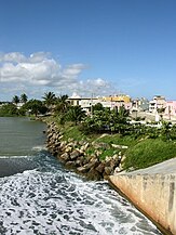 View of Arecibo from the mouth of Río Grande de Arecibo
 -
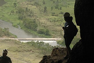 View of the river from Cueva Ventana
 -
 Río Grande de Arecibo from Cueva Ventana after it rained


See also[edit]
- Cambalache Bridge: NRHP listing in Arecibo, Puerto Rico
- List of rivers of Puerto Rico
References[edit]
- ^ Fewkes, J. Walter (1903). "Prehistoric Porto Rican Photographs". American Anthropologist. 5 (1): 44. doi:10.1525/aa.1903.5.3.02a00020.
- ^ Monroe, Watson H. (1980). Some Tropical Landforms of Puerto Rico. Department of the Interior. p. 12.
{{cite book}}:|work=ignored (help) - ^ Rio Grande de Arecibo, Puerto Rico: Environmental Impact Statement. 1991. pp. 6–.
- ^ "USACE: $3.348 billion go toward reducing flood risk in Florida, Puerto Rico and USVI". Caribbean Business. 6 July 2018.
- ^ "Para la Naturaleza recibirá $2.5 millones para proyectos de restauración en la cuenca del río Grande de Arecibo". El Nuevo Día (in Spanish). 2021-04-27. Retrieved 2021-06-20.
- ^ "Proyecto de canalización del río Grande de Arecibo comenzará en 2023 [Río Grande de Arecibo canalization project will begin in 2023]". El Vocero de Puerto Rico (in Spanish). 2021-06-16. Retrieved 2021-06-20.
External links[edit]