
Rocky Arbor State Park
| Rocky Arbor State Park | |
|---|---|
IUCN category V (protected landscape/seascape) | |
 Entrance at Rocky Arbor State Park | |
  | |
| Location | Wisconsin, United States |
| Nearest town | Wisconsin Dells, Wisconsin |
| Coordinates | 43°38′31″N 89°48′21″W / 43.64194°N 89.80583°W |
| Area | 244 acres (99 ha) |
| Authorized | 1932 |
| Governing body | Wisconsin Department of Natural Resources |
Rocky Arbor State Park is a 244-acre (99 ha)[1] Wisconsin state park in the Wisconsin Dells region. The park was established in 1932 to protect sandstone outcrops eroded into picturesque walls and ledges.
Natural history[edit]
The region is formed from Late Cambrian sandstone deposited 500 million years ago at the bottom of shallow inland seas. Much later the Wisconsin River flowed over this tract of land, carving channels into the sandstone. The river has since changed course, now running 1.5 miles (2.4 km) to the east, leaving the rock walls of its former gorge exposed. A small creek now flows through the park, though in the opposite direction as the river once did..
-
 Ranger Station
 -
 Sign
Sign -
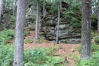 Outcrop


Recreation[edit]
Situated in a major tourist area, Rocky Arbor State Park has well-developed visitor amenities despite its small size. There is a campground with 89 campsites (18 of them with electrical hookups), showers, flush toilets, a playground, dump station, and picnic area. A single loop trail provides views of the rock ledges, with a spur trail to the campground. The park is open to vehicle traffic only in the summer. During the off-season visitors can park at the gate and enter the grounds on foot.

Climate[edit]
| ||||||||||||||||||||||||||||||||||||||||||||||||||||||||||||||||||||||||||||||||||||||||||||||||||||||||||||||||||||||||||||
References[edit]
- Wisconsin Department of Natural Resources. Rocky Arbor State Park signage, brochures, and website.
- ^ "Rocky Arbor State Park". Wisconsin Department of Natural Resources State Parks.
- ^ "NASA Earth Observations Data Set Index". NASA. Retrieved January 30, 2016.
External links[edit]
| Authority control databases: National |
|---|