
Sindi, Estonia
Sindi
Sindi | |
|---|---|
.jpg) | |
 Sindi Location in Estonia | |
| Coordinates: 58°24′2″N 24°40′3″E / 58.40056°N 24.66750°E | |
| Country | |
| County | |
| Municipality | Tori Parish |
| Population (2020) | |
| • Total | 3,790 |
| • Rank | 32nd |
| Ethnicity | |
| • Estonians | 81.1% |
| • Russians | 14.8% |
| • other | 4.1% |
| Time zone | UTC+2 (EET) |
| • Summer (DST) | UTC+3 (EEST) |
Sindi (German: Zintenhof) is a town in Tori Parish, in Pärnu County, Estonia,[1] with a population of 3906 in 2017. It is located 14 kilometers from the county capital Pärnu, on the left coast of the Pärnu river.
History[edit]
The area of what is now Sindi was the site of the Mesolithic settlement of Pulli, dating from around 8500 BCE – the oldest known settlement in Estonia. It was discovered by geologists in 1965. The settlement probably existed for a short period, as the area was later covered by water. As a swampy region, the area remained unpopulated until the 16th century.
The town's name is derived from Clauss Zindt, a mayor of Pärnu in 1565, who founded a manor (Zintenhof) where the town is now. The settlement was formed in 1833 around a textile factory owned by the manor. It officially became a borough in 1921 and a town in 1938.
Important to the town's development was the founding of a railway station in 1928. The railway operated until 1970.
Geography[edit]
Sindi is located on the left bank of the Pärnu River, between the river and the wetland of Lanksaare.
Notable people[edit]
- Uno Palu (1933-2024), decathlete
- Allar Raja (born 1983), rower
- Julius Seljamaa (1883–1936), politician and diplomat
- The Tuberkuloited, rock band originally from Sindi
Gallery[edit]
-
 Railway station building
 -
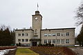 Town hall of Sindi
 -
 Historical Sindi schoolhouse
 -
 Sindi Eastern Orthodox church
 -
 Sindi library
 -
 Residential building
 -
 Former Sindi dam


References[edit]
- ^ "X-GIS(3) Portal". xgis.maaamet.ee. Retrieved 3 February 2022.
External links[edit]
- Official website (in Estonian)
| ||
Jaanilinn (Ivangorod) and Petseri (Pechory) were annexed by the Soviet Union in 1945 and are currently part of Russia. | ||
| Urban municipalities | ||
|---|---|---|
| Rural municipalities | ||
| International | |
|---|---|
| National | |
| Geographic | |
This Estonia location article is a stub. You can help Wikipedia by expanding it. |