
Tõstamaa Parish
Tõstamaa Parish
Tõstamaa vald | |
|---|---|
 Tõrvanõmme pine | |
 Flag  Coat of arms | |
 Tõstamaa Parish within Pärnu County. | |
| Country | |
| County | |
| Administrative centre | Tõstamaa |
| Area | |
| • Total | 261.01 km2 (100.78 sq mi) |
| Population (01.01.2006) | |
| • Total | 1,572 |
| • Density | 6.0/km2 (16/sq mi) |
| Website | www.tostamaa.ee |
Tõstamaa Parish (Estonian: Tõstamaa vald) was a rural municipality in southwestern Estonia. It was a part of Pärnu County. The municipality had a population of 1,572 (as of 1 January 2009) and covered an area of 261.01 km2.[1]
Tõstamaa Parish covered part of the flat seashore of western Pärnu County, a low, swampy coastal area bordered by an elevated chain of sand dunes. Behind the dunes spreads a slightly wavy drumlin, where higher places have been reclaimed, but lower ones have remained swampy or meadowland and covered with scattered foliage. And, although Tõstamaa should mean "high land", its populace have long lived not off the land, but off the sea.
Several islands and islets in the Gulf of Riga, including Sorgu and Manilaid, belong to Tõstamaa Parish.
Tõstamaa is home to the historic Tõstamaa Keskkool.
Settlements[edit]
- Small borough
- Villages
Alu - Ermistu - Kastna - Kavaru - Kiraste - Kõpu - Lao - Lõuka - Manija - Männikuste - Päraküla - Peerni - Pootsi - Rammuka - Ranniku - Seliste - Tõhela - Tõlli - Värati
Gallery[edit]
-
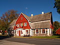 Tõstamaa community house
 -
 Tõstamaa manor house
 -
 Manija village centre on Manilaid island
 -
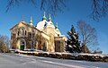
 Seliste church
 -
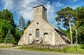
 Pootsi-Kõpu church
 -

-
 Tõstamaa church
 -
 Peerni harbor


References[edit]
- ^ "Population figure and composition". stat.ee Statistics Estonia. Retrieved 7 February 2010.
External links[edit]
- Official website (in Estonian, English, and Finnish)
| Urban municipalities | ||
|---|---|---|
| Rural municipalities | ||
58°19′59″N 23°59′56″E / 58.333°N 23.999°E
This Estonia location article is a stub. You can help Wikipedia by expanding it. |