
Talk:Control of cities during the Syrian civil war/Archive 21
| This is an archive of past discussions. Do not edit the contents of this page. If you wish to start a new discussion or revive an old one, please do so on the current talk page. |
| Archive 15 | ← | Archive 19 | Archive 20 | Archive 21 | Archive 22 | Archive 23 | → | Archive 25 |
Shaer Gas field
This edit request to Template:Syrian Civil War detailed map has been answered. Set the |answered= or |ans= parameter to no to reactivate your request. |
First of all I thought Shaer was a gas and not oil field ? Second, IS took this place three days ago or am I looking at some different location ? 31.176.240.213 (talk) 00:15, 20 July 2014 (UTC)
why it's in red again ?
This was captured by ISIS or the army retake that ? --Pototo1 (talk) 03:39, 20 July 2014 (UTC)
- Syrian forces after launching a counter-attack, had "re-taken areas of Sha'er gas field. Naharnet SOHR Hanibal911 (talk) 07:51, 20 July 2014 (UTC)
I dont quite understand it. Where is the source claiming that the Syrian army had retaken Shaer ? link , link and yesterday IS posted photos after they managed to repel the attack led by NDF members. Sunday 1 DeadNDFmembers DeadNDFmembers2 3 and so on and forth ..
- The Syrian special forces forced the ISIS to pull to outskirts of Sha'er gas field.SOHR Hanibal911 (talk) 15:58, 21 July 2014 (UTC)
Does it strike anyone else as downright laughable that this map doesn't show the IS within 400 miles of Shaer? Or is it just me? Boredwhytekid (talk) 16:08, 21 July 2014 (UTC)
From https://twitter.com/EjmAlrai/status/491239229104861184, it seems that IS is in control. In presence of contradicting sources, and of ongoing clashes, I suggest to put it contested red-black and wait. Paolowalter (talk) 16:26, 21 July 2014 (UTC)
 Not done: it's not clear what changes you want to be made. Please mention the specific changes in a "change X to Y" format. —cyberpower ChatOnline 18:57, 21 July 2014 (UTC)
SOHR, the most reliable source, reported yesterday the Army captured the gas field with ISIS remaining in the outskirts. Today we have more reports of fighting. We are in a reverse situation now, with ISIS being in the outskirts, and army mostly in control, with fighting ongoing. It would be appropriate to mark it as before just reverse. Before it was black plant icon with red ring, now red plant icon with black ring. EkoGraf (talk) 21:52, 21 July 2014 (UTC)
- Second Boredwhytekid (talk) 13:11, 22 July 2014 (UTC)
SOHR, it's not the "most reliable source" they are basically a anti Syrian government group, they support ALL factions who decided attack the Syrian Army - Yes is a source who we can used I agree but no the "most reliable source"
SOHR the equivalent to Syrian perspective. --Pototo1 (talk) 00:52, 23 July 2014 (UTC)
why Rahjan in Hama was change to red to green ?
Some one is changing this town to contested and latter to green but this place was in red according to previously map.
If you have a source I want to see that remember the SOHR, pro Insurgents twitters accounts are not sources is against the rules used anti government sources to showing progress from insurgensts (All insurgents) against the government.
I think If nobody have solid sources Rahjan in Hama should be change to red again. --Pototo1 (talk) 23:04, 17 July 2014 (UTC)
if you check the history edit,you will see that there was a source mentioned. Alhanuty (talk) 02:33, 18 July 2014 (UTC)
I no found just link that if you have that. --Pototo1 (talk) 05:19, 18 July 2014 (UTC)
http://syriahr.com/index.php?option=com_news&nid=21059&Itemid=2&task=displaynews. Alhanuty (talk) 22:09, 21 July 2014 (UTC)
Is against the rules used anti government sources to showing anti government insurgent gains- Have something different ?--LogFTW (talk) 03:35, 22 July 2014 (UTC)
In this pro insurgent source are not direct mention about Rahjan on text it meaning to 300+ killed on Gas camp in Homs, the insurgents here probability meaning to this place to "Syrian the defense minister's village" on the tittle only, but there are not a single source who suggests the insurgents captured it at all.
Here said the insurgent just "Attack" with truck bomb they no controlled that, they attack before the location with truck bomb too according with this another source and the location was keeping on red.
Personally I think the insurgents controlling nothing there, seem is just blah blah blah from SOHR who support the Insurgents but based on the sources (Who quoiting the SOHR) the most pro Insurgent decision who we can do is but the place contested.
- You cite http://news.yahoo.com/syrian-rebels-attack-defense-ministers-village-122651803.html and say it doesn't say rebels took any of the village, but it does (SOME of the village). Here's a Kurdish source which is NOT citing SOHR http://aranews.net/2014/07/syria-rebels-advance-hama/ that claims rebels took the entire thing. Contested is probably the way to go.. Do you have any sources to the contrary? Boredwhytekid (talk) 20:33, 22 July 2014 (UTC)
- Ara News is the pro opposition Kirdish source which support by rebels and it cant be used for display rebel advances against the army. Hanibal911 (talk) 20:45, 22 July 2014 (UTC)
- Pro-Kurdish outlets are as anti-FSA and anti-IS as they are anti-Assad.. in this conflict the Kurds have spent more time fighting FSA and IS than Assad anyway. "Opposition" is too sweeping of a term - especially when groups covered by that umbrella term are literally killing each other..Boredwhytekid (talk) 12:28, 23 July 2014 (UTC)
I no found a single source with "Credibility" who suggests the insurgent controlled this place The Washington Times and same case they just "Attack" the village with a car bombs and "Control" Severals parts but never said the Insurgents captured it at all.
I no have problem you can keep it on green but if we take these pro insurgents claims as true we need to used Syrian Perspective Reports as true too who many times are refused --Pototo1 (talk) 13:24, 23 July 2014 (UTC)
"Eastern Palestine"
This edit request to Template:Syrian Civil War detailed map has been answered. Set the |answered= or |ans= parameter to no to reactivate your request. |
Please remove the contested icon in Hassakah province, below Jaz'ah, that is labeled "Eastern Palestine". Unless I'm missing something here.. Boredwhytekid (talk) 12:38, 23 July 2014 (UTC)
- The edit: [1]. I used [2] to find the official name and the latitude and longitude of the village. --Ahmetyal (talk) 13:28, 23 July 2014 (UTC)
So, that village is actually named Eastern Palestine? Haha if so, my bad. I thought it was just some trolling action Boredwhytekid (talk) 13:45, 23 July 2014 (UTC)
Boredwhytekid is adding news towns on map without sources ?
I'm not 100% sure but I think the user Boredwhytekid is adding three towns on map without sources names are = Buraghayti, Tall Salmu and Umm Jurayn three very small towns near the Active Army held Abu al-Duhur air base.
I think he adding these three news towns after I open a discussion here showing that as evidence from pro and anti government sources the airbase was not under siege anymore when some TV channels doing a extensive tours inside the air base.
But Boredwhytekid voted for keep the base under siege and he additionally adding three news towns for the Insurgents near the air base. But doing that is against the rules so before I draw some town in As-Suwayda Governorate who are not on map and changes were deleted many times.
So the rule is simple you need to have a specific source for add a specific town to map he is adding there news towns on map without sources of that. For add these three news towns Buraghayti, Tall Salmu and Umm Jurayn three very small towns near the Active Army held Abu al-Duhur air base. you need to links sources if the sources no exist it should be deleted - If I'm wrong so my apologies for Boredwhytekid .......................................
Towns without sources here on map in brown circles
--LogFTW (talk) 19:14, 23 July 2014 (UTC)
Elba gas plant , strategic location in Homs
This report notes the importance of this strategic location (elba gas plant) and says its "dozens of kilometers from Sha’ir field" where fighting is currently occurring. http://www.al-monitor.com/pulse/security/2014/07/ayria-isis-advance-hama-homs-shair-field-energy-control.html Is this already located on the map? It looks like a lot more fighting to come in this zone. — Preceding unsigned comment added by 169.231.3.204 (talk) 03:22, 24 July 2014 (UTC)
New icon for Al-Nusra Front
We need the new icon for noted the cities which control of Al-Nusra because in accordance with the new data Al-Nusra Front decided to act independently and began fighting against the FSA and in the wake behind ISIS wants create your caliphate.sourcesourcesource Source said that Al Nusra Front have seized three strategic towns on the border with Turkey in a major blow to US-backed moderate rebels. Nusra’s seizure of Azmarin, Salqin and Harem in Syria’s Idlib province came only four days after the group seized Darkoush, another border town, from the Syrian Revolutionary Front, a moderate group that is part of the Western-backed Free Syrian Army. Rami Abdurrahman, the head of the SOHR, said he believed the capture of the four towns was Nusra’s effort to build a geographically contiguous area that would be declared its Islamic state. Hanibal911 (talk) 09:20, 23 July 2014 (UTC)
according Nusra is in total war with FSA. dark green maybe? as part of the rebellion but differentiated at once.
I suggest to wait and see what happens,similar fights appened between rebels and ISIS multiple times before the all out war between the 2 groups.FS1991 13:25, 23 July 2014 (UTC)
- Agreed - the rebellion has been plagued by internecine fighting; it may be fleeting. If it persists for some time though, another color/shade will be appropriate. Boredwhytekid (talk) 12:50, 23 July 2014 (UTC)
I agree with Hanibal911 especially there have been several indication of Al-Nusra intention to distance itself from other opp groups and has been rallying other islamic groups under its league to announce its proper Islamic Khalifa. http://al-akhbar.com/node/210763 http://al-akhbar.com/node/210688 (Ali bachir (talk) 18:10, 23 July 2014 (UTC))
- SOHR confirmed that Al Nusra continued clashes against other rebel groups.SOHRThus I think that we need noting this grouping on the map different icon. Hanibal911 (talk) 19:41, 23 July 2014 (UTC)
If this continues I suggest to use a grey icon to display Nusra territories FS1991 23:34 23 July 2014 (UTC) — Preceding unsigned comment added by 79.2.119.50 (talk)
Another article just published today about Al-Nusra conflict with other groups and its plan to make its its own "Islamic State" http://al-akhbar.com/node/211545 Ali bachir (talk) 00:08, 24 July 2014 (UTC)
Mr. Ali....Al Akhbar is not a reliable source, but a Farsi Hezbollah propaganda rag... — Preceding unsigned comment added by 80.184.104.88 (talk) 15:02, 24 July 2014 (UTC)
The report is about a press release by the Islamic Front regarding the situation we are discussing or the leaked audio recording of Al-Nusra leader Al-Joulani Regarding there intention to form there own state, and in addition major opp sources like SOHR are also reporting the clashes. And about your comment on Al-Akhbar i dont think Hezbollah propaganda include promoting Secularism and Gay Rights the way this paper do. But ofcourse i do aknowledge that it is a pro-Hezbollah paper. Ali bachir (talk) 18:07, 24 July 2014 (UTC)
Kafrzita
This edit request to Template:Syrian Civil War detailed map has been answered. Set the |answered= or |ans= parameter to no to reactivate your request. |
I belive this town should go just green as the regime has no presence here since February.
Map from May , and July , I know both maps are pro-oppositin but it's quite obvious.
- You're going to need third party reliable source for this edit. Mlpearc (open channel) 00:24, 26 July 2014 (UTC)
Thanks for the maps but we need to have a specific source talking about that specific town or place.
Easy examples = 1 2 --Pototo1 (talk) 01:10, 26 July 2014 (UTC)
Shaer gas field
according to sohr saa capture and full control shaer gas field : http://www.syriahr.com/index.php?option=com_news&nid=21360&Itemid=2&task=displaynews — Preceding unsigned comment added by 151.250.23.28 (talk) 18:24, 26 July 2014 (UTC)
Official confirmation http://www.sana.sy/en/?p=8139 --LogFTW (talk) 18:32, 26 July 2014 It seems like IS withdraw form Shaer for some reason . may be it was a diversion to their attacks on 17 division and 121 regiment.
Division 17 and Regiment 121 in Raqqa and Hasakah respectively
http://www.islandpacket.com/2014/07/24/3226091/islamic-state-presses-syria-offensive.html
Many sources have been reporting the fall of division 17 to the Islamic State, while Regiment 121 close to Hasakah is partially overwhelmed, with SOHR reporting clashes between IS and regime soldiers inside the city of Hasakah. Since that is a neutral source(among many not so much neutral sources also reporting) I would recommend you guys to change Division 17 to ISIS held. — Preceding unsigned comment added by 179.181.81.3 (talk) 01:36, 25 July 2014 (UTC)
Div 17 Change to black.
Some one remove the black circle around it. --Pototo1 (talk) 03:53, 25 July 2014 (UTC)
From the infos collected, it seems that only part of the Div 17 has been taken. There are contradictory statements. Better wait and keeping red with black ring. For the Regiment 121 I have not seen any reliable source yet.Paolowalter (talk) 10:38, 25 July 2014 (UTC)
There is a specific process we have to go through when marking a loss for the regime.
First we must wait until at least one month has passed with the regime not taking back control of the area. Then we need SANA and Al Manar to confirm the news. Finally there has to be rumors that the regime is losing towns close to the town in question. Then, we can change the color from red to red/green or red/black. Of course, a red circle will be kept around this town, probably for a year or two. — Preceding unsigned comment added by 80.184.104.88 (talk) 11:42, 25 July 2014 (UTC)
The ISIS insurgents not encircle the regimen 121 how showing the map they in the west from 121 Regiment in Hasakah according to this ma is pro government but credibility very good
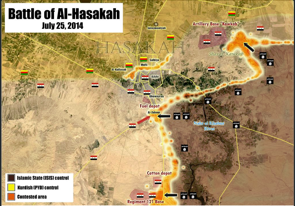
About the Div 17 Nothing confirmed at the moment the ISIS showing some soldiers beheading -> http://www.liveleak.com/view?i=113_1406258044 Here the BBC http://www.bbc.com/news/world-middle-east-28481283 but they just quoting the anti Government SOHR
Some anti government reports claim the solders trapped or at least part of them try to withdraw to Ayn Issa who is in Army control (map is in black need fixing that) http://www.syriahr.com/index.php?option=com_news&nid=21304&Itemid=2&task=displaynews#.U9JnR7EXIeA --Pototo1 (talk) 15:42, 25 July 2014 (UTC)
- According to new data IS militants attacked the military base Division 17 but did not take it. Sources said that in Raqa province, which is mainly held by IS, the jihadists attacked two positions of the army's 17th Division, sparking fighting that left dozens of dead and wounded, the Observatory said. In one attack, two suicide bombers -- one a Saudi -- blew up trucks packed with explosives. "At least six soldiers, one an officer, were decapitated and eight jihadists were killed," the Observatory said.Yahoo NewsNahatnetNOW NewsThe Daily StarAgence France-Presse Hanibal911 (talk) 16:12, 25 July 2014 (UTC)
Read the SOHR page now. It looks like they are not sure what has happened. SOHR writes: "al-Raqqa province: clashes continue around the 17th division, a regime's convoy backed up by helicopters and warplanes is moving from al-Salamia to al-Raqqa . conflicted reports about the fate of 900 regular soldiers whether if they pulled back into the 93 brigade in EIn Essa, or they are still inside the 17th division, amid air strikes on ISIS bastions inside and around the division." pro-gov source claims SAA repelled multi-wave assault killing 520 enemies. http://www.syrianperspective.com/2014/07/syrian-army-division-17-kills-520-isis-savages-in-spectacular-defensive-operation.html While other reports claim the majority of SAA have fled to base to the north. Either or both of these reports could be propaganda.
We need to wait.
ISIS fanboys claims they controlled the "Major Part" of the base http://www.liveleak.com/view?i=574_1406293578 --Pototo1 (talk) 17:54, 25 July 2014 (UTC)
First pictures published by the RMC inside division 17. , and this is the northern part
SOHR now confirmed it http://syriahr.com/index.php?option=com_news&nid=21314&Itemid=2&task=displaynews#.U9K2tfldWSp Alhanuty (talk) 19:59, 25 July 2014 (UTC)
IS claim captured the officers barracks on 17 Division the pictures but from bodies beheading are from outside of division on Raqqah city. https://www.youtube.com/watch?v=wkvDvXArzjo
- At the moment seems the attack on North East of Hasakah was repelled according official reports https://www.youtube.com/watch?v=Y4ejdKfiiiQ --Pototo1 (talk) 20:24, 25 July 2014 (UTC)
Syrian sama TV is talking about Raqqah but need a Arabic talker https://www.youtube.com/watch?v=BSu4W-bdG5w
According to this source, http://www.al-monitor.com/pulse/security/2014/07/violent-attack-syria-army-islamic-state-raqqa-hasakah.html#, both attacks on division 121 and division 17 failed.Here is another source about Division 17, http://www.aawsat.net/2014/07/article55334708 — Preceding unsigned comment added by 2602:30A:C01B:89F0:4C1F:A767:8E14:8CED (talk) 22:54, 26 July 2014 (UTC)
Most sources suggests Ayn Issa is controlled by Army
This map (probability neutral credibility low) showing Ayn Issa (July 7) under army control http://umap.openstreetmap.fr/fr/map/desyracuse-syria-civil-war-7-july-2014_12153#15/36.3836/38.8653
Pro government map (Credibility good) showing Ayn Issa under army control (July 6) https://twitter.com/PetoLucem/status/485716436678365184/photo/1
Anti government map (Credibility good) showing Ayn Issa under army control (May 5) http://sia1.subirimagenes.net/img/2014/07/25/140725074249501527.jpg
Anti government SOHR suggests the 25/7 this zone is controlled by Army too on this report https://www.syriahr.com/index.php?option=com_news&nid=21304&Itemid=2&task=displaynews#.U9JnR7EXIeA
2 sources anti government
1 Pro government
1 Neutral and same result in the 4 fourth sources suggest this place is controlled by the Army --Pototo1 (talk) 17:51, 25 July 2014 (UTC)
One more from Anti Government SHOR suggest Ayn Issa is controlled by Army http://syriahr.com/index.php?option=com_news&nid=21314&Itemid=2&task=displaynews#.U9K2tfldWSp
And pro government twitter https://twitter.com/EjmAlrai/statuses/492922372953878528 — Preceding unsigned comment added by Pototo1 (talk • contribs) 16:49, 26 July 2014 (UTC)
On Wikimapia is visible how part the Brigade 93 are part from Ayn Issa Tonw http://wikimapia.org/#lang=es&lat=36.376999&lon=38.855467&z=15&m=b
I vote for move keeping it in red — Preceding unsigned comment added by Pototo1 (talk • contribs) 18:01, 26 July 2014 (UTC)
This pro government source report the Army captured Ayn Issa in June 2013 and latter https://www.facebook.com/syria24english/posts/539393969429723 in November 2013 http://www.syriatimes.sy/index.php/news/local/6406-syrian-arab-army-imposes-control-over-raqqa-s-ayn-issa-town-advances-in-barzeh-suburb
- These Anti government sources no said that in of explicitly form the Army controlled Ayn Issa but suggests that 12
It's not enough ?
Larousse is a very hard line anti government source.........--Pototo1 (talk) 06:12, 27 July 2014 (UTC)
Hasakah city and the villages and towns between Shadadi and Hasakah city
it logically doesn't make sense that the government still controls these areas especially after IS seized the 121th regiment,also user: zenithfel brought a reliable source to confirm that http://online.wsj.com/articles/islamic-state-militants-confront-syria-forces-in-rare-confrontation-1406239224 . Alhanuty (talk) 19:01, 26 July 2014 (UTC)
Source makes no mention of the towns and villages between the two being ISIS-controlled (last reports had them government-held) and, logic or not, we can not make personal and unsourced POV edits. EkoGraf (talk) 22:44, 26 July 2014 (UTC)
According to pro-kurdish ArdaPress regime pulled out from the center of Hasakah city and YPG is now in control of the area, anyone has got sources confirming or denying? [1]
190.67.225.100 (talk) 00:40, 27 July 2014 (UTC)
Same source actually says joint patrols between the YPG and Assad forces will be conducted. In any case, we would need an independent source for this. EkoGraf (talk) 01:45, 27 July 2014 (UTC)
Kurdish Anti-PYD site Aranews has also reported the same, with additional info about 350 YPG soldiers being deployed to Melebiya regiment, which I suppose is 121:
http://aranews.net/2014/07/ypg-pro-assad-forces-enemy-enemy-friend/
In any case, yes, will have to wait for other sources, as pro-KDP sites tend to publish anything that indicates YPG-SAA cooperation regardless of veracity.
190.67.225.100 (talk) 07:27, 27 July 2014 (UTC)
Need more Sources to put the Regiment 121 in Hasakah on ISIS insurgents hands.
The anti government source used to change the map no mentioned the Regimen 121 https://www.facebook.com/syriahroe/posts/560274404080902 it's just talking about a convoy.
Some one have something more? — Preceding unsigned comment added by Pototo1 (talk • contribs) 20:01, 26 July 2014 (UTC)
IS insurgent Captured the regiment 121 confirmed by pro gov source. --Pototo1 (talk) 20:13, 26 July 2014 (UTC) https://twitter.com/PetoLucem/statuses/493038638083891200
The source is just quoting opposition sources. Other tweets from opposition report that the regiment 121 has been taken only partially. See if the fall is confirmed. Paolowalter (talk) 20:57, 26 July 2014 (UTC)
The pro-government source is quoting opposition sources. The SOHR facebook post did say ISIS managed to take control of the base, however, the original Arabic version of the report states they managed to take only part of the base with fighting continuing [3]. Due to this, for now, best course of action would be to leave red dot with black ring. EkoGraf (talk) 22:40, 26 July 2014 (UTC)
for the arabic source,this might have been before the total control,but the pro-regime source confirmed that the base fell,https://twitter.com/p_vanostaeyen/status/493110484254883841 .Alhanuty (talk) 23:00, 26 July 2014 (UTC)
There is no before, it is not up to us to speculate. SOHR Facebook is there to present English version/copies of their Arabic reports, and the original report in Arabic states clearly the base is still being contested. As for the twitter report. I thought it was agreed to only use maps via twitter, no written statements, especially ones based on propaganda images. EkoGraf (talk) 01:37, 27 July 2014 (UTC)
the pro-government source even admitted it,and now there is reports of clashes in hasakah city itself.
also if you notice the arabic report came nine hours ago https://www.facebook.com/syriahro/photos/a.10150329947968115.393926.326766683114/10152628548408115/?type=1&permPage=1 meanwhile the english report came 8 hours ago https://www.facebook.com/syriahroe/posts/560274404080902 so the english report is newer Alhanuty (talk) 02:55, 27 July 2014 (UTC)
From http://aranews.net/2014/07/ypg-pro-assad-forces-enemy-enemy-friend/ it seems that the regiment has been retaken by SAA and Kurds forces. It will be reverted to red. The same sources states that the villages al-Karama and al-Khama’el must go black. I cannot locate the former but I am changing the latter black. Paolowalter (talk) 09:52, 27 July 2014 (UTC)
http://www.dailystar.com.lb/News/Middle-East/2014/Jul-27/265274-jihadists-make-fresh-syria-advance-activists.ashx Actually a neutral source is reporting Regiment 121 to be under the Islamic State control, mantain Regiment 121 as black. — Preceding unsigned comment added by 201.22.81.30 (talk) 11:01, 27 July 2014 (UTC)
Additionale info from other sources (I do not how reliable) http://breakingnews.sy/en/breakingnews/28817.html; https://www.facebook.com/Syrian.Truth.en/posts/800745113277386 the last is pro-gove and talks of progress toward the regiment.
As to dailystar article, the new of aranews above is first hand and more recent. Most of the media are reporting today yesterday new. Paolowalter (talk) 11:48, 27 July 2014 (UTC)
Adar Press reports that YPG and SAA attacked IS at Qanna/Hanna 18 km south of Hasakah city, also says something about regiment 121 but can't really make it:
190.67.225.100 (talk) 17:02, 27 July 2014 (UTC)
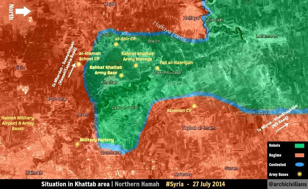
Khitab
Why is Khitab indicated in green? Is it because of this SOHR post? SOHR SOHR is a pro-opposition source, even more heavily since its recent change of tone. It can't be used for indicating opposition advances. Kihtnu (talk) 09:01, 27 July 2014 (UTC)
Change Khattab and Rahbeh in Hama to Green: http://www.dailystar.com.lb/News/Middle-East/2014/Jul-27/265274-jihadists-make-fresh-syria-advance-activists.ashx
Daily Star is a neutral source and a respect newspaper. — Preceding unsigned comment added by 201.22.81.30 (talk) 10:58, 27 July 2014 (UTC)
Fuck off with your dailystar and SOHR crap. Prove it or stop posting bullshit. dailystar is anti Assad.
Put Khitab as rebel. You editors have to be kidding. http://en.wikipedia.org/wiki/Daily_Star_(Lebanon) Wikipedia article on Daily Star. A respected newspaper say it's rebel, who are you waiting to confirm it, Jesus? I know you are all pro-regime(to edit in favor of the regime, you take any source and say it's pro-rebel and it's talking about regime taking control). When a decently respected newspaper with worldwide release say that Assad lost a town, he LOST THE TOWN. Get over it and CHANGE KHITAB TO GREEN — Preceding unsigned comment added by 201.22.81.30 (talk) 19:38, 27 July 2014 (UTC)
^ Calm down the newspaper who you link is just repeating the same who said the SOHR who is anti government town still in conflict according pro government reports https://twitter.com/PetoLucem/status/492965989399924736 and I see that on map in Green atm --Pototo1 (talk) 19:50, 27 July 2014 (UTC)
Rebels are showing vedios from Khitab and tropgies. I agree to keep it green http://eaworldview.com/2014/07/syria-daily-a-multi-front-battle-between-assad-forces-islamic-state/ — Preceding unsigned comment added by 72.208.35.223 (talk) 01:01, 28 July 2014 (UTC)
Frankly, I don't see any cross fact checking from The Daily Star here. I see more a "Laziness journalism" case, so common in newspapers now, than another thing. It seems they just copy a SOHR statement and this is it. Also, please stop judging people on mere intent. Kihtnu (talk) 09:57, 28 July 2014 (UTC)
Halfaya
This edit request to Template:Syrian Civil War detailed map has been answered. Set the |answered= or |ans= parameter to no to reactivate your request. |
Maybe this town, and i think the circle should be smaller, should go contested ? Civilian convoy fleeing to south as clashes intensified. Reports about clashes mainly on pro.op sites, still waiting for an neutral source A pro-opposition map 37.203.114.243 (talk) 20:41, 28 July 2014 (UTC)
Youtube not accepted as a source by Wikipedia. Pro-opposition maps not accepted as sources for rebel advances, besides, the map doesn't show the town contested. It shows rebels near the town's eastern outskirts. EkoGraf (talk) 03:15, 29 July 2014 (UTC)
The whole town is under government control according to the pro insurgent map who you link, this is not a map about held territory, and is against the rules used pro insurgent sources to showing insurgents advances --Pototo1 (talk) 03:40, 29 July 2014 (UTC)
Regiment 121 for IS and Khitab for rebels
http://www.dailystar.com.lb/News/Middle-East/2014/Jul-27/265274-jihadists-make-fresh-syria-advance-activists.ashx#axzz38fUZ9UJn edited their topics, but they ignored this source in favor of the usual regime sources, which are random twitter guys called pro-rebel. Change those 2, as this is neutral source and Daily Star is a respect news source, and if they are quoting SOHR is because they most likely could independently verify. To change those please.
ISIS withdrew from the regiment 121 in al-Melebiya after bombardment by the pro-regime warplanes and artillery shelling by the Syrian military forces in Hasakah.Source : http://aranews.net/2014/07/ypg-pro-assad-forces-enemy-enemy-friend/ — Preceding unsigned comment added by 92.44.118.134 (talk) 18:03, 27 July 2014 (UTC) IS seems to still in 121 Regiment. Only pro government sources say they are not. http://www.liveleak.com/view?i=2d0_1406431168
There were airstrikes by the government against them though. As for the the Juvenile prison, courthouse and Arabic majority neighborhoods in Hasaka. only YPG propaganda claims they are in control. YPG used to say they are Gri Sor when every other sources said they were expelled, so their sources are not reliable. YPG says they are allied with the regime in Hasaka and with the rebels in Ayn Al Arab.
If any one hear a confirmation from IS or SOHR are rebel sources. add it please. thanks to all editors. — Preceding unsigned comment added by 72.208.35.223 (talk) 00:48, 28 July 2014 (UTC)
The article from neutral source makes it appear as if Regiment 121 remains in gov control: http://www.al-monitor.com/pulse/security/2014/07/violent-attack-syria-army-islamic-state-raqqa-hasakah.html##ixzz38gQTvQ5Ehttp://www.al-monitor.com/pulse/security/2014/07/violent-attack-syria-army-islamic-state-raqqa-hasakah.html# — Preceding unsigned comment added by 169.231.67.15 (talk) 17:48, 29 July 2014 (UTC)
The article states that government claims they are in there while IS claims they are in there too IS has vedios and picture supporting their claim. thanks you for providing the sources though. I will go for leaving it black or black with a red circle. but not red with black circle, since IS are already in there and the govermnent attems to have it back — Preceding unsigned comment added by 72.208.35.223 (talk) 21:36, 29 July 2014 (UTC)
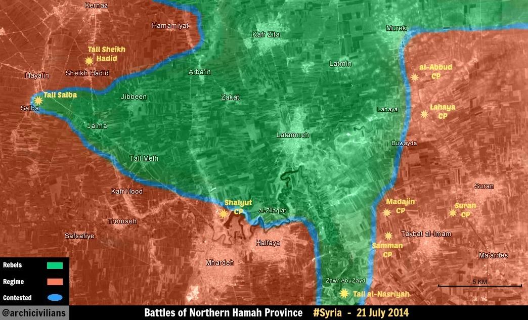
Tell Salba and jalama
saa captures Tell Salba and jalama (north of hama) according to document sy https://www.facebook.com/documents.sy/posts/761436857252406 — Preceding unsigned comment added by 92.44.168.153 (talk) 16:03, 29 July 2014 (UTC)
In https://twitter.com/KeepingtheLeith/status/494164813811941376 the town captured are jalama and Tell Mahl. The original report is in arab, that I can't read. On pro-opp tweet there is the following https://twitter.com/archicivilians/status/494185986075533312 that confirms jalama and Tell Mahl taken by SAA, but it is not very clear. Furthermore https://twitter.com/archicivilians/status/494068969846743040 states that Tall Salba was captured also and https://www.facebook.com/syriahroe/posts/561469397294736 states that there are clashes between Tall Salba and Tell Mahl. I would put all red with green rings. What do you think? Paolowalter (talk) 21:19, 29 July 2014 (UTC)
I think Tell Salba, Jalama, and Safsafiyah should go contested ? — Preceding unsigned comment added by 37.203.123.48 (talk) 23:48, 29 July 2014 (UTC)
Ar-Ruhayyat
I think Ar-Ruhayyat (red dot above Raqqa) should be black. I read that the SAA retreated from the villages around Raqqa and went to either the Tabqa airbase or Base 93 near Ayn Isa. — Preceding unsigned comment added by 99.42.96.49 (talk) 05:49, 30 July 2014 (UTC)
Semi-protected edit request on 30 July 2014
This edit request to Template:Syrian Civil War detailed map has been answered. Set the |answered= or |ans= parameter to no to reactivate your request. |
Three black circles for Khirbat ar Ruzz, need to remove the excess. 87.117.178.100 (talk) 07:33, 30 July 2014 (UTC)
 Done
Done
Tal Salmo contested?
According to https://www.facebook.com/syriahroe/posts/561746350600374 this town next to the Military Airport of Abo Al Dohor is contested, Should be mark it as such? Paolowalter (talk) 10:26, 30 July 2014 (UTC)
Dear objective user,
i urge to you to watch how pro rebels changing maps time to time without any source(reliable) a hope that would STOP!!! if any of pro assad user changes map they all jump and attacking!!!! Please can someone stops this mess — Preceding unsigned comment added by 94.102.233.227 (talk) 06:27, 31 July 2014 (UTC)
Source says in the Tal Salmo area, not Tal Salmo itself. EkoGraf (talk) 06:35, 31 July 2014 (UTC)
According to SyrPer Al-Mawrek (Mork or Morek) is been almost taken by SAA. At least SAA is in the town centre while the rebels are in the peripheric neighbourhoods. [4] — Preceding unsigned comment added by Archinovista (talk • contribs) 07:43, 31 July 2014 (UTC)
Ayash and Ain al-Bou Jimaa in Deir Ez Zor province controlled by the Army (Official source)
Official Syrian source report the Armed controlled a places called Ayash and Ain al-Bou Jimaa in Deir Ezzor western countryside.
The army regained control over Ayash and Ain al-Bou Jimaa villages in Deir Ezzor western countryside.
A source in Deir Ezzor told SANA that units of Army regained full control over Ayash and al-Bou Jimaa villages.
- Source 1 (Official Syrian Government)
- Source 2
- Source 3
- Source 4
- Source 5
- Source 6
- Source 7
- Source 8
- Source 9
If it's now on map sorry for be dumb.
Ayash is now red with black ring, but I could not locate al-Bou Jimaa. Anybody can help?Paolowalter (talk) 19:12, 20 July 2014 (UTC) Ayash is fixed stilling needing Ain al-Bou Jimaa for draw that if it exist --Pototo1 (talk) 14:38, 21 July 2014 (UTC)
User Paolowalter Ayash to red to black used source https://www.facebook.com/syriahroe/posts/561285363979806 there NO said said IS captured the town and is anti government anyway is against the rules used anti government sources to showing insurgents gains against the government.--Pototo1 (talk) 01:56, 31 July 2014 (UTC) I know these rules much better than you who just joined the editors. After long discussion, we agrees by consensus that SOHR can be accepted as sources, therefore the above change is due,. Please revert your change.Paolowalter (talk) 07:57, 31 July 2014 (UTC)
The Insurgents really controlled Khitab (Khattab) in Hama ?
Some sources said a place called Khitab (Khattab) was captured by the Insurgents but If I'm not wrong in insurgents in this place Khitab (Khattab) killed 14 civilians at July 8 and are visible how the Government troops are in the area https://www.youtube.com/watch?v=jjUMGw1B4gI http://www.liveleak.com/view?i=f92_1404993467 http://www.liveleak.com/view?i=a9d_1406227327
Is only the anti government SOHR for Human rights the only source who claim it's now controlled by rebels ? — Preceding unsigned comment added by Pototo1 (talk • contribs) 06:24, 31 July 2014 (UTC)
Indeed, is there not any other sources than SOHR (A pro-opposition organisation, let's remember this) to assess the situation in Northern Hama? Or medias, such as The Daily Star, taking SOHR statements as face value? That's decidely too light for making changes on the map on those bases alone. Some people are really ignoring the basic rules of this Wikipedia template. Kihtnu (talk) 07:25, 31 July 2014 (UTC)
Rebels capture rahbet khattab (army base) ,north of khattab and we see more than 10 videos and photos. But we didnt see a single photo or a video about rebels capture khattab.And goverment source denied that.I think army still control khattab.And We now that sohr is pro opposition, especially in these days.And only sohr says khattab under rebel control.Dailystar and other sources To quote from sohr.And remeber aleppo prison.Sohr says rebel capture aleppo prison.(sorry my bad english) — Preceding unsigned comment added by 82.222.101.117 (talk) 11:53, 31 July 2014 (UTC)
Al Jazeera report, also it says the regime army left the town without much casualties. — Preceding unsigned comment added by 109.175.59.20 (talk) 15:48, 31 July 2014 (UTC)
It is rahbet khattab army base .Not khattab town. — Preceding unsigned comment added by 82.222.101.117 (talk) 18:09, 31 July 2014 (UTC)
Did you heard what the reported said ? He's talking about the town and not the base. — Preceding unsigned comment added by 109.175.89.155 (talk) 21:10, 31 July 2014 (UTC)
this Video from rahbet khattab base.Not from khattab TOWN.Only sohr says khattab under rebel control.But no evidence.No video or no photo inside khattab TOWN.It is sohr propaganda.And we know that regime source arrested people days ago inside khattab TOWN. — Preceding unsigned comment added by Frontflipy (talk • contribs) 09:29, 1 August 2014 (UTC)
South Nawa
This edit request to Module:Syrian Civil War detailed map has been answered. Set the |answered= or |ans= parameter to no to reactivate your request. |
I actually haven't noticed this until today. The clashes in these small towns of Tassel and Adwan started maybe in January, as far as I remember, and they lasted for 2-3 months, but after that the Syrian army retreated to Nawa, which is now contested too (logically). This should be Tassel, an some newer informations about the shelling of these two towns, June, July 109.175.48.39 (talk) 17:41, 1 August 2014 (UTC)
Ayyash is in Government control stop to change that to black.
On this anti this anti government Source government Source NO Said the Islamic State insurgent captured Ayyash READ WELL it.
And is important to know the SOHR is a anti government is against the rules used Anti government sources for showing advances against the government from all insurgents groups.
Official Syrian source report the Army controlled Ayyash and Ain al-Bou Jimaa in Deir Ezzor western countryside here are many sources.
- Source 1 (Official Syrian Government)
- Source 2
- Source 3
- Source 4
- Source 5
- Source 6
- Source 7
- Source 8
- Source 9
TV Report are visible two more TV Channels on the area
Source 1Source 2Source 3Source 4Source 5Source 6Source 7Source 8Source 9Source 10 vs Anti government Source
10 extensive reports including visual confirmation from professional Journalists in the Terrain vs just 1 SOHR link who NEVER said the Insurgent captured the town.
Common..................... --Pototo1 (talk) 14:57, 31 July 2014 (UTC)
All the infos about SAA capturing the town are based on government source. Actally it was accepted and I changed it to red. Nevertheless, later news from SOHR reported that IS retook the town. SOHR credibility can (and must) be questioned, but it was decided to accept it. Unfortunately, we are very short of neutral sources on the ground. We'll keep monitoring and thre is conflicting reports, we can put it contested. Paolowalter (talk) 10:10, 1 August 2014 (UTC)
The 50% from the SOHR is a lie anyway in this anti government claim is = Deir Ezzor Province: The SOHR has been informed that the Islamic State warned the people of Ayyash village to evacuate the area due to the proximity of a military action against the Brigade 137 which is close to the village.
There not said this was captured / recaptured.
Dude ten sources Source 1Source 2Source 3Source 4Source 5Source 6Source 7Source 8Source 9Source 10 including extensive visual confirmation is not enough ? --Pototo1 (talk) 19:51, 1 August 2014 (UTC)
Hasakah city
I know that Rudaw is a Kurdish source, but it confirms that SAA has completely withdrawn from the Hasakah Province. YPG has taken their territory + the village of Kitish. [5]. --Ahmetyal (talk) 09:55, 31 July 2014 (UTC)
Read well the source there said "Hasakah province"
Hasakah province = Rural areas Hasakah city = The city
Same case with Damascus
Damascus province = Damascus rural areas Damascus City = The urban capital --Pototo1 (talk) 20:05, 1 August 2014 (UTC)
Deir Ezzor
This edit request to Template:Syrian Civil War detailed map has been answered. Set the |answered= or |ans= parameter to no to reactivate your request. |
It looks like rebels, who gave up the fight against ISIS during their offensive, now have started to take back some smaller towns. Unfortunately I have no idea how to find "Official" IS sites. First day of clashes. I guess a neutral source Pro-opposition tweet Pro-opposition tweet2 Rebels in Grajin Rebels in Grajin2 AbuHamam Rebels reppeling attack in E-DeirEzzor Destroyed ISIS car https://www.youtube.com/watch?v=vrVrNbgXUz4 https://www.youtube.com/watch?v=Q4nT3w19roM https://www.youtube.com/watch?v=SjJVjAGOBgI https://www.youtube.com/watch?v=7S1lt2WKMwU https://www.youtube.com/watch?v=ZB-7-G6RT3E 109.175.89.155 (talk) 20:58, 31 July 2014 (UTC)
- Those were not rebels,actually they are tribal fighters from Shaitat tribe and now they control this villages after ISIS fighters pulled out,so a blue dot for this villages is more appropriate https://now.mmedia.me/lb/en/nowsyrialatestnews/558302-islamic-state-withdraws-from-syria-villages (talk) 21:17, 1 August 2014 (UTC) — Preceding unsigned comment added by 95.247.119.185 (talk)
the map
Why was the map moved, and why now the map has disappeared? Alhanuty (talk) 01:02, 2 August 2014 (UTC)
Idlib Province
Pretty extensive pro-opposition report http://iswsyria.blogspot.com/2014/07/rebel-operations-in-idlib-province.html that suggests a number of changes to the map. Neutral/Gov't sources needed to confirm before used for editing. Boredwhytekid (talk) 17:52, 1 August 2014 (UTC)
- Most significant changes suggested: Fanar checkpoint near Ariha was destroyed/taken by rebels at the beginning of the recent surge of violence in Idlib - also claimed by pro-opp http://eaworldview.com/2014/05/syria-report-major-insurgent-offensive-idlib-province/. And Hanajk checkpoint near Maarat al-Numan - also claimed by pro-opp https://www.facebook.com/photo.php?fbid=950618898298580. Still looking for neutral/gov't sources. Boredwhytekid (talk) 18:05, 1 August 2014 (UTC)
Pro-regime source. SRF rebels storming the checkpoint, and here
A neutral source showing Hesh village under rebel control. — Preceding unsigned comment added by 109.175.48.39 (talk) 18:15, 1 August 2014 (UTC)
Youtube is not accepted as a source on Wikipedia. EkoGraf (talk) 10:38, 2 August 2014 (UTC)
Hasaka
The user Ahmetyal tried to change the status of a major city as Hasaka based on partisan and incorrect sources. Such major changes have to discussed in the talk page to reach a consensus and rushed by a single (little known) editor. There is no conflict ongoing between YPG and the government and Hasaka is jointly administrated. It is not event obvious, if the different coloured areas on the map area are really meaningful. Paolowalter (talk) 12:36, 31 July 2014 (UTC)
Seems as vandalism case everyone known since long time ago the Kurdish insurgent controlled part from Hasakah City but Very Extensive parts from Hasakah City area are in government control it's a Huge city
Days before
- the Report from the Islamic State attack Repelled Official report from SANA 27/7/14
- Kuwait News agency 27/7/14 Syrian army units control some areas in Hasakah
- Syrian News Channel Reports from School in Hasakah 24/7/14
- SAMA TV Report from Hasakah city 23/7/14
- SAMA TV Report from Hasakah 22/7/14
- SAMA TV Report from Hasakah 3/7/14
- SAMA TV Report from Hasakah city 3/7/14
The only major city when the government troops no have presence is how everyone know Al Raqqah since many time agoPototo1 (talk) 17:36, 31 July 2014 (UTC)
Why is hasakah yellow?Source? — Preceding unsigned comment added by 82.222.101.117 (talk) 18:11, 31 July 2014 (UTC)
Kurdish sources have been reporting YPG to have taken full control of Hasakah city and Assad forces to have fully retreated from the Hasakah governorate. But it is a Kurdish non-neutral source, so obviously you guys can't change, as not only the sources are not neutral, but not all kurdish sources have reported that. We will see what happens later on.
________________
According to al-akhbar (lebanese pro-Hezbollah paper), the southern neighborhoods of Hasakah are under control of both YPG and SAA:
1- http://www.al-akhbar.com/node/212380&usg=ALkJrhirmx1-cByirta_Q06g66S8Fy6Hkw
2- http://www.al-akhbar.com/node/212213&usg=ALkJrhjJIgwYyDLq6A1mORE7PWC5M4X3ww
First article states that YPG and SAA are fighting together against the Islamic State at the gates of the city while additionaly SAA (seemingly supported by NDF) captured a village and a junction southeast of Hasakah.
Second article states pretty much the same (plus spokeman of YPG declaring willingness to cooperate with "anyone" against IS), but additionally confirms that YPG and SAA fought together to recapture the Power Station, which in the map is marked as held by SAA only, and that Regiment 121 still remains under Islamic State control.
This echoes previously linked articles which indicated cooperation between both sides in the city but that were deemed unreliable due to being from kurdish media.
The question now is how (in case that this source is deemed valid enough) will these changes be represented in the map, northern areas can remain yellow since regime forces haven't been there for more than a year, would orange or mixed bars of red and yellow work for the areas between N. Hasakah and the Power Station? And as for the Station itself, maybe replacing it with a three ring circle?
190.66.146.247 (talk) 02:03, 1 August 2014 (UTC)
The pro-kurdish sources that had previously mentioned the alliance:
http://aranews.net/2014/07/ypg-pro-assad-forces-enemy-enemy-friend/
http://adarpress.net/index.php/2013-07-29-08-54-39/3694-%25D9%2585%25D9%258F%25D8%25B1%25D8%25A7%25D8%25B3%25D9%2584%25D9%2586%25D8%25A7-%25D8%25A7%25D8%25B4%25D8%25AA%25D8%25A8%25D8%25A7%25D9%2583%25D8%25A7%25D8%25AA-%25D8%25B9%25D9%2586%25D9%258A%25D9%2581%25D8%25A9-%25D9%2581%25D9%258A-%25D8%25A7%25D9%2584%25D8%25AD%25D8%25B3%25D9%2583%25D8%25A9%25D8%258C-%25D9%2588ypg-%25D8%25AA%25D8%25B5%25D9%2584-%25D8%25A5%25D9%2584%25D9%2589-%25D9%2582%25D8%25A7%25D9%2586%25D8%25A7-%25D8%25AC%25D9%2586%25D9%2588%25D8%25A8-%25D8%25A7%25D9%2584%25D9%2585%25D9%258A%25D9%2584%25D8%25A8%25D9%258A%25D9%2591%25D8%25A9&usg=ALkJrhgJe--x5E4f88vngoyU2Kjyzuz7hA — Preceding unsigned comment added by 190.66.146.247 (talk) 02:17, 1 August 2014 (UTC)
And a photo which according to pro-Kurdish Twitter activists depicts three YPG soldiers posing in front of the Power Station:
https://twitter.com/mutludc/status/494378092065193984
190.66.146.247 (talk) 02:24, 1 August 2014 (UTC)
![[6]](https://pietervanostaeyen.files.wordpress.com/2014/08/2000px-syria5.png)
He put it like that based on Rudaw and various other pro-kurdish sources, the closest thing to an independent report we have is the al-akhbar one which states both forces are allied from the southern/central neighborhoods of the city to the area surrounding the Power Station.
190.67.129.94 (talk) 23:10, 1 August 2014 (UTC)
According to the France 24 report kurds control all of the city except for the center which is under SAA, and Guerran neighborhood which has IS presence.
Seems like those changes could be sensible, anyone going to do them?
190.67.129.94 (talk) 18:34, 2 August 2014 (UTC)
Syrian Wikipedia editors; Map has a lot of mistakes
I would like to ask if Syrian editors could make more then one edit because there are so much wrong information on the map. It is not important which side we support but it is important to show the people the ″Reality on ground″ in Syria and this map is not so realistic. At first it was more pro-opposition and now pro-government, especially in Hama province. Thanks. — Preceding unsigned comment added by YasminSham88 (talk • contribs) 18:01, 2 August 2014 (UTC)
Some pro Insurgents account are doing a lot crazy editions since days ago, something need to be fixed especially changes added using only pro insurgents sources for showing insurgents advances. If some pro Insurgents users read in SOHR facebook page "Clashed in the Vicinity" from specific town under Army control they usually put all the whole town in conflict
Hama need be fixing I think Daraa and Some areas in Hasakah need to be fixing too. --Pototo1 (talk) 21:29, 2 August 2014 (UTC)
SOHR
I have appreciated this map for its neutrality, its rules of edition and especially its cautiousness. But now, apparently, SOHR is considered as a neutral source, and thus, deemed reliable for stating opposition advances. SOHR provides interesting information and certainly reliable at some point (Except the highy suspicious daily human toll). But, please, let's not forget that SOHR is heavily pro-opposition (Just look at their logo), and just can't be used for stating any opposition advances if these statements are not independantly confirmed. These confirmations don't include mass medias, like The Daily Star, which just take SOHR statements at face value, without any trace of fact checking. It is high time to halt editions, on Northern Hama for example, over such weak sources, in order to keep a reliable map. Thank you.Kihtnu (talk) 07:26, 1 August 2014 (UTC)
This was discussed about half a dozen times and decided SOHR's reports, even though pro-opposition, turn out in 95 percent of the cases to be accurate and it has been used by the reliable international media outlets and called by them an authoritative source on Syria. EkoGraf (talk) 11:28, 1 August 2014 (UTC)
They lying a lot times remember the Aleppo prison case they claimed 300 prisioners frezzed by insurgents and was a total bullsh1t.
Just a single example how they misrepresent the things http://www.liveleak.com/view?i=5d6_1404357767
They lying a lot in the kill rate too the 99% of the times they always put the Army causalities more higher than the insurgents it's not possible because army got more firepower and insurgents are in infighting...
SOHR = Anti Syrian State propaganda machine, it's not Syrian it's in London --Pototo1 (talk) 00:40, 3 August 2014 (UTC)
SAA advancing in Hasakah
according to sohr Regime forces and NDF fighters advanced and took control over the villages of Al Homor, Al Slaleyyi, Al Fallaha, Al Ma’ruf and Al Maqbara reaching to the old junction of Al Shaddadi. source:https://www.facebook.com/syriahroe/posts/562706100504399 — Preceding unsigned comment added by Frontflipy (talk • contribs) 06:51, 1 August 2014 (UTC)
saa advancing in shaddadi and you guys make all area black.Nice pro IS map — Preceding unsigned comment added by Frontflipy (talk • contribs) 10:22, 1 August 2014 (UTC)
Who made all the town south of Hasaka black? I cannot remember that any source justified this change. On the basis if the previous SOHR source Shaddaded should be with a red ring (or contested). Paolowalter (talk) 11:07, 1 August 2014 (UTC)
- Maqbara - http://www.geonames.org/maps/google_36.629_40.56.html / http://wikimapia.org/#lang=en&lat=36.629436&lon=40.560326&z=16&m=b per http://www.mapaction.org/component/mapcat/download/2753.html?fmt=pdf Boredwhytekid (talk) 20:23, 1 August 2014 (UTC)
![]() Al Maqbara is added according to wikimapia link in a bit rare location.
Al Maqbara is added according to wikimapia link in a bit rare location.
But still needing to add Al Homor, Al Slaleyyi, Al Fallaha and Al Ma’ruf --Pototo1 (talk) 15:25, 2 August 2014 (UTC)
Syrian Army captures 5 villages:
al-Hemer: 36.503; 40.807, al-Salaliah: 36.489; 40.824, al-Falahah, al-Marouf and al-Maqbara. All 5 villages lie to the soutteast of al-Hasakah city. The Army didn't reached al-Shaddadeh they reached the old junction of Shaddadeh (u can see the street on the map). I added now al-Hemer and al-Salaliah.
Someone put the villiage of Maqbara to the northwest it is wrong and Sheddadeh should be black with no red circle. — Preceding unsigned comment added by YasminSham88 (talk • contribs) 17:20, 2 August 2014 (UTC)
The map from Hasakah city inserted is from Larousse anti government source it should be updated
About who change all these towns in Hasakah province to black / greens could be Alhanuty he usually change to red to black / Green or Yellow a lot towns using any very low credibility source or no read well the source who he is adding if the pro insurgent SORH
He do a lot crazy editions without publish sources on talk page just fews time ago he trolling the map putting ALL Hasakah city in Yellow................
Here is the entire historical editions https://en.wikipedia.org/w/index.php?title=Template:Syrian_Civil_War_detailed_map&action=history
![]() Al Maqbara is added (I dunno if that is the 100% correct location here is the link).
Al Maqbara is added (I dunno if that is the 100% correct location here is the link).
![]() Al-Hemer is added
Al-Hemer is added
![]() Al-Salaliah is added
Al-Salaliah is added
Still needing to add Al Fallaha and Al Ma’ruf
___________
Al Maqbara eliminated location most probability is incorrect.
![]() Al-Hemer is added
Al-Hemer is added
![]() Al-Salaliah is added
Al-Salaliah is added
Still needing to add Al Maqbara, Al Fallaha and Al Ma’ruf
Need the cords from these three places --Pototo1 (talk) 01:16, 3 August 2014 (UTC)
Tu'alsya
This edit request to Module:Syrian Civil War detailed map has been answered. Set the |answered= or |ans= parameter to no to reactivate your request. |
Heavily Pro-regime site showing this town under rebel control. There's also this village Fan ash Shamali but not listed on this wiki map. I think the dots should be moved a bit to the south. 92.36.215.131 (talk) 20:55, 2 August 2014 (UTC)
We need a specific source talking a specific town for add a new town on map we no based that on maps about held territories from pro or anti regime maps.
On Tartus / Latakia / As-Suwayda are many towns under army control we can't draw it because is a rule have at least one source for draw a specific town. --Pototo1 (talk) 00:07, 3 August 2014 (UTC)
the rule is a pro-regime source admits a rebel gain we use it.Alhanuty (talk) 04:35, 3 August 2014 (UTC)
It's not a source it's a map about held territory no a source talking about specific town
Government advances in Hasakah
SOHR is reporting this morning that "...regime forces and NDF fighters advanced and took control over the villages of Al Homor, Al Slaleyyi, Al Fallaha, Al Ma’ruf and Al Maqbara reaching to the old junction of Al Shaddadi."
Can this be included? Thanks --CommieMark (talk) 11:03, 1 August 2014 (UTC)
Yes, someone please find them on the map and add please. Thank you. EkoGraf (talk) 11:29, 1 August 2014 (UTC)
I cannot find the villages but I put a red ring around Shaddadi. Paolowalter (talk) 12:11, 1 August 2014 (UTC)
found the cords and draw it must towns be size 5 to 6 no more than it. --Pototo1 (talk) 20:26, 1 August 2014 (UTC)
Maqbara - http://www.geonames.org/maps/google_36.629_40.56.html / http://wikimapia.org/#lang=en&lat=36.629436&lon=40.560326&z=16&m=b per http://www.mapaction.org/component/mapcat/download/2753.html?fmt=pdf Boredwhytekid (talk) 20:41, 1 August 2014 (UTC)
why was the map moved from the template to a module.Alhanuty (talk) 22:58, 1 August 2014 (UTC)
Al Maqbara is on map now stilling needing the wikimapia links to Al Homor, Al Slaleyyi, Al Fallaha and Al Ma’ruf
Syrian Army captures 5 villages:
al-Hemer: 36.503; 40.807, al-Salaliah: 36.489; 40.824, al-Falahah, al-Marouf and al-Maqbara. All 5 villages lie to the soutteast of al-Hasakah city. The Army didn't reached al-Shaddadeh they reached the old junction of Shaddadeh (u can see the street on the map). I added now al-Hemer and al-Salaliah.
Someone put the villiage of Maqbara to the northwest it is wrong and Sheddadeh should be black with no red circle.
Who wrote the above should sign. I agree on Maqbara and turned the red into black. I also found strange the presence of SAA in Sheddadeh. Could you point out where the "old junction of Shaddadeh" is located? The two villages of al-Hemer and al-Salaliah are located on the large map. Either this map is removed od it has to be updated regularly. Some black ares must go red. Because the city is not really contested between SAA and YPG, it could just be turned like Qamishli. Finally the source used to turn Brigade 121 red is old and not confirmed by anybody. Unless new development take places, it should be still black. Paolowalter (talk) 14:29, 3 August 2014 (UTC)
Khattab
According to sohr rebels clashes with the regime forces in the Rahbet of the Khattab town.Khattab should be contested source: https://www.facebook.com/syriahroe/posts/563918757049800 — Preceding unsigned comment added by 195.155.234.13 (talk) 13:25, 3 August 2014 (UTC)
Source says in the vicinity of the towns, not in the towns themselves. EkoGraf (talk) 17:12, 3 August 2014 (UTC)
The Khattab military base has got a red ring already.Paolowalter (talk) 19:01, 3 August 2014 (UTC)
Jibeen
This edit request to Module:Syrian Civil War detailed map has been answered. Set the |answered= or |ans= parameter to no to reactivate your request. |
Pro-government map showing this town under rebel control, here with the name Jubbayn. 109.175.44.190 (talk) 22:47, 3 August 2014 (UTC)
Looking at wikimapia http://wikimapia.org/#lang=it&lat=35.351256&lon=36.509113&z=13&m=b it is wasy to see that Jubbayn is misplaced on the map. Between Kernaz and Al-Jalamah there is Shayik Hadid not Jubbayn. Jubbayn is further east. Therefore I do not know how to interpret the map in this point. Paolowalter (talk) 07:00, 4 August 2014 (UTC)
We no used maps from Held territories for draw news towns only sources Specific source for Specif town (70% of the times we used anti government sources) the main reason from this rule is avoid a "War of maps"
But personally I no have problem you can draw it.
Peto Lucem (Pro Gov) and Labrousse (anti gov) maps usually be right most times. --Pototo1 (talk) 03:10, 4 August 2014 (UTC)
About Rahbet Khattab army base
Rahbet Khattab army base location is north of khattab.Not south of khattab http://wikimapia.org/#lang=tr&lat=35.203252&lon=36.653996&z=15&m=b&gz=0;366557550;352025507;858;52597;27035;0;79392;15077;66946;65220;0;48040Frontflipy (talk) 07:47, 4 August 2014 (UTC)
And al sheer is west of khattab and near of majdal ,not south of khattab http://wikimapia.org/#lang=tr&lat=35.201937&lon=36.621723&z=14&m=b&gz=0;366130542;351871724;0;88380;44631;0;150203;34371;130462;119241;6866;70845 — Preceding unsigned comment added by Frontflipy (talk • contribs) 07:52, 4 August 2014 (UTC)
Regiment 121 recaptured by SAA and YPG?
According to hardcore pro-regime Syrian Perspective Regiment 121 was recaptured from IS by SAA, NDF and YPG, I know that Syrper alone does not warrant a change but if some other more neutral source reports please do post it here:
http://www.syrianperspective.com/2014/08/isis-terrorists-giving-up-in-al-hasakah.html
Also do we have a way to represent dual control for zones other than cities? ie bases and gas fields. — Preceding unsigned comment added by 190.67.129.94 (talk) 05:18, 3 August 2014 (UTC)
As I know the Regiment 121 days ago some sources reported including visual evidences the ISIS insurgents captured it partiality (East Part of the regiment) but few time and Latter army doing a counter attack retaking severals zones who the ISIS captured before https://www.youtube.com/watch?v=D7z175rPqqA
Latter according with anti government reports the army gain five news towns
The town near the regimen is probability in Army hand Al-khama'ill I dunno why it was change to black, I'm 80% sure some one change it to black without sources. --Pototo1 (talk) 17:43, 3 August 2014 (UTC)
You are completely wrong and your opinion must not influence the map. The change was done based on source by me (I guess). Now I changed back to black as it is likely to be. Paolowalter (talk) 19:01, 3 August 2014 (UTC)
The change to red of the Regiment 121 is not backed by reliable source. That quoted (that I have already read some time ago) did not receive any confirmation. In view of the importance of the position, a reconquer by SAA would recieve a large coverage. Waiting for further and more reliable news, I turn it black again (unfortunately).Paolowalter (talk) 19:14, 3 August 2014 (UTC)
Al-khama'ill could be still in government hand I'm almost sure there are not sources about ISIS controlled Al-khama'ill town --Pototo1 (talk) 19:36, 3 August 2014 (UTC)
Look at http://www.liveleak.com/view?i=fb7_1406496921 https://www.facebook.com/syriahroe/posts/395459097229101
Paolowalter (talk) 19:48, 3 August 2014 (UTC)
^ On SOHR link (Anti government source) no said the ISIS captured or captured Al-khama'ill town the other are just the comments from pro ISIS Account "Asiruh" on Liveleak he could be right but it's not a source --Pototo1 (talk) 14:52, 4 August 2014 (UTC)
Brigade 61
This edit request to Module:Syrian Civil War detailed map has been answered. Set the |answered= or |ans= parameter to no to reactivate your request. |
This checkpoint near Nawa was captured by rebels months ago. SOHR SOHR2 7 videos inside the brigade tweet from last month Videos from last month, inside the base DuckZz (talk) 16:41, 3 August 2014 (UTC)
You need to carefully read your sources. Since military installations belonging to Brigade 61 who were near the town of Sheikh Saad which taken a month ago already marked under rebel control. Also remember that amateur video clips from YouTube are not reliable sources and this video cant be used to edit the map. Hanibal911 (talk) 17:03, 3 August 2014 (UTC)
The base was mostly recaptured by the military the following month. Sources were presented at the time. Also, youtube is not permitted as a source. EkoGraf (talk) 17:06, 3 August 2014 (UTC)
Not a problem, but I still belive rebels do control it — Preceding unsigned comment added by DuckZz (talk • contribs) 14:54, 4 August 2014 (UTC)
Clashes in Southwestern Aleppo countryside:
This edit request to Module:Syrian Civil War detailed map has been answered. Set the |answered= or |ans= parameter to no to reactivate your request. |
Army took one base and 2 towns near Khan Tuman which are Saqlaya and Sherfee(Southwestern aleppo). Source: http://www.eremnews.com/?id=54085&&headline=%D8%B3%D9%88%D8%B1%D9%8A%D8%A7..-%D9%85%D8%B9%D8%A7%D8%B1%D9%83-%D9%83%D8%B1-%D9%88%D9%81%D8%B1-%D9%81%D9%8A-%D8%AD%D9%84%D8%A8-%D9%88%D8%B1%D9%8A%D9%81%D9%87%D8%A7
Also Khan Tuman is contested.
Bbros33 (talk) 09:36, 5 August 2014 (UTC)
Hama province
Fan ash Shamali is incorrectly placed on our map. It should be due south of Tulaysiyah http://wikimapia.org/#lang=en&lat=35.346187&lon=36.913067&z=13&m=b. Also, based on this pro-gov't map http://www.syrianperspective.com/2014/08/new-map-of-hama-offensive.html the entire area between Tulaysiyah and Fan ash Shamali is rebel controlled, so the two tiny villages Shaatah and Junaynah should both be lime.
Please relocate Fan ash Shamali to it's proper location http://wikimapia.org/#lang=en&lat=35.312002&lon=36.915135&z=15&m=b and change the status of the villages Shaatah and Junaynah from SAA controlled to rebel controlled per pro-gov't http://www.syrianperspective.com/2014/08/new-map-of-hama-offensive.html Boredwhytekid (talk) 17:55, 4 August 2014 (UTC)
- But this source is not specified that these villages under rebel control. That's when these villages will be marked under rebel control only then we can change status these villages. Hanibal911 (talk) 19:23, 4 August 2014 (UTC)
How long are we going to cripple the map this way? That's a pro-gov't source showing the villages under rebel control. The villages in question are tiny 20 building sites, and they will never be mentioned in the news again. But we'll leave them red, even though the rebel front line has moved past them. What a joke. Let's at least put Fan ash Shamali in its correct location so we can pretend that the map gives a credible representation of Hama province.
How about just taking the villages off of the map? They are miniscule. I get that we can't make them lime because they are not specifically named in any source, fine; but, leaving them red behind rebel lines is a misrepresentation that just makes this map look foolish - ESPECIALLY when we have pro-gov't sources showing that the SAA doesn't control them. Boredwhytekid (talk) 19:59, 4 August 2014 (UTC)
- I have corrected the coordinates of the villages which you noted!Geo names But dont need distort the information from the source because it does not say that the rebels captured these villages so if there the front line was held in area where located this villages this does not mean that all villages in the area captured by rebels. Hanibal911 (talk) 20:09, 4 August 2014 (UTC)
Thank you. Distort the information? It shows the area under rebel control.. clearly. Look at any other syrianperspective map - areas cut off behind enemy lines are always clearly shown (Kuweyres Airbase, Nubl, Brigade 93, Division 17, etc.) It's a pro-gov't map - it would not willingly show the rebels in control of a location where the SAA is present. Are we going to use reason at all? Just drop them from the map if you don't want them lime I don't care - but leaving them red and there is blatantly false. Boredwhytekid (talk) 20:30, 4 August 2014 (UTC)
the pro-regime map shows not only tulaysia and al fan al shamali is opposition-held,but also the surrounding area,so the villages shaatah,junaynah,qaser al mukharam,al-zughbah,balil,as opposition.Alhanuty (talk) 22:03, 4 August 2014 (UTC)
- You must stop distort information obtained from sources because this source does not indicate that these villages captured by rebels so you must stop unjustified statements but if we follow your logic then with the help pro opposition maps we can add on the map all cities in the Suwayda province and mark them in red. Hanibal911 (talk) 05:48, 5 August 2014 (UTC)
Are you looking at the same map as us? It clearly shows the entire area between Tulaysiyah and Fan ash Shamali as rebel held. And, that is exactly where those tiny villages are. Again, they are not specifically named so we can't change them to lime. But we can remove them to show more clearly the actual situation on the ground, because the gov't is not holding those 20 buildings directly behind the main rebel offensive. This is the type of obstinacy that makes this map a joke. Come on already - display the truth or what are we even doing here. Boredwhytekid (talk) 12:20, 5 August 2014 (UTC)
Frika checkpoint
This edit request to Module:Syrian Civil War detailed map has been answered. Set the |answered= or |ans= parameter to no to reactivate your request. |
Just saw this video of IF blowing up this checkpoint in Frika town, also posted on their twitter acc, but on this map I can only see a cp named "Manattah al-Harariyah" .. is that a mistake or ? 31.176.243.220 (talk) 21:00, 5 August 2014 (UTC)
new icons available for testing
A few weeks back there was a request for new icons for partially besieged/front line locations. Finally I got around to doing it. They are available here.
There are semicircles in 8 directions for each of the regime, rebels, kurds, and the ISIS.
As well, I made 4 circle icons for fully besieged locations, which may make editing easier.
They have all yet to be tested on a real map, which I'll do in the next few days. André437 (talk) 20:01, 3 August 2014 (UTC)
Not bad idea but you should be change the word "Regime" and replace that by "Government" the term "Regime" is used by the pro Insurgent media mostly.
So we can call Israel = Israel Regime / USA = USA regime --Pototo1 (talk) 22:06, 3 August 2014 (UTC)
- The main rebels, the kurds, and the ISIS are all trying to change the regime (system of government), not just the government in place (Assad and his supporters). So from a political science perspective, regime is more appropriate than government.
- As for the example of Israel, Hamas would refer to it as a regime (wanting to destroy Israel as a country), and possibly also Hizbolla and Iran. Few would want to change the (democratic) regime of the USA, even though many may want to change the government of the day.
- In any case, the descriptions aren't the icons. André437 (talk) 02:29, 4 August 2014 (UTC)
So according with your logic the FSA / Al Qaeda and Islamic Front could be called "Obama Regime" because they are supported and armed by US Government..........
ALL GROUP who fighting with the government troops need to have the authorization from the Syrian government and follow the orders from the Syrian government.
I agree with you idea but just put there the damn word Government "Regime" is a incorrect term.
The pro Insurgent media called the Syrian State as "Regime" because they want generated the typical atmosphere "Oppressed people" vs "Dictatorial Regime" this is a old movie anyway... --Pototo1 (talk) 02:57, 4 August 2014 (UTC)
- A series of emotional arguments against a technically correct term. (Although "government" would also be correct, it is not the focus of the various opposition groups, armed and unarmed.)
- Seriously, do you really believe that the "FSA / Al Qaeda and Islamic Front" are an integral part of the US system of government ? (Never mind the fiction that the US is in any way supporting "Al Qaeda".) André437 (talk) 10:21, 6 August 2014 (UTC)
André437, the icons look great, thanks a bunch. Now if we can just get the community to use them.. Boredwhytekid (talk) 12:01, 4 August 2014 (UTC)
- I'll do some tests on a real map in the next few days. The icons might still need some adjusting.
- The new map module (made at the end of July) requires some modifications for my map tests, but the plus is that testing will be on a sub-page of the new module. André437 (talk) 10:21, 6 August 2014 (UTC)
- ^ http://www.adarpress.net/index.php/2013-07-29-08-54-39/3688-%D9%85%D9%8F%D8%B1%D8%A7%D8%B3%D9%84%D9%86%D8%A7-%D8%AF%D9%88%D8%B1%D9%8A%D8%A7%D8%AA-%D9%85%D9%8F%D8%B4%D8%AA%D8%B1%D9%83%D8%A9-%D8%A8%D9%8A%D9%86-ypg-%D9%88%D9%82%D9%88%D8%A7%D8%AA-%D8%A7%D9%84%D9%86%D8%B8%D8%A7%D9%85-%D9%81%D9%8A-%D8%A7%D9%84%D8%AD%D8%B3%D9%83%D8%A9%D8%8C-%D9%88%D9%84%D8%A7-%D8%A3%D8%AB%D8%B1-%D9%84%D9%84%D9%85%D9%8F%D9%82%D9%86%D9%91%D8%B9%D9%8A%D9%86-%D9%81%D9%8A-%D8%A7%D9%84%D9%85%D8%AF%D9%8A%D9%86%D8%A9