
Tatabánya
Tatabánya | |
|---|---|
 Tatabánya in June 2008 | |
 Flag  Coat of arms | |
 Tatabánya  Tatabánya | |
| Coordinates: 47°35′10″N 18°23′41″E / 47.58616°N 18.39485°E | |
| Country | |
| Region | Central Transdanubia |
| County | Komárom-Esztergom |
| District | Tatabánya |
| Government | |
| • Mayor | Ilona Szűcsné Posztovics (Independent) |
| • Town Notary | Dr. Gergely Berkovics |
| Area | |
| • Total | 91.42 km2 (35.30 sq mi) |
| Elevation | 167 m (548 ft) |
| Population (2022) | |
| • Total | 64,305[1] |
| • Rank | 12th |
| Area code | 34 |
| Motorways | M1 |
| Distance from Budapest | 60.1 km (37.3 mi) East |
| Website | www |
Tatabánya (Hungarian: [ˈtɒtɒbaːɲɒ] ⓘ; German: Totiserkolonie; Slovak: Banská Stará) is a city with county rights of 64,305 inhabitants in northwestern Hungary, in the Central Transdanubian region. It is the capital of Komárom-Esztergom County.
Location[edit]
The city is located in the valley between the Gerecse and Vértes Mountains, some 55 km (34 mi) from the capital. By virtue of its location, the city is a railway and road junction. The M1 (also European routes E60, E75) motorway from Vienna to Budapest passes through the outer city limits, and the Vienna-Budapest railway line also passes through the city.
History[edit]
Archaeological findings prove that humans have been living here since the Stone Age. The three historic predecessor settlements of Tatabánya are Alsógalla, Felsőgalla, and Bánhida. Bánhida is the earliest settlement, it was first mentioned in 1288.[citation needed]
In the 16th century, the Ottoman Turks occupied the area. Around this time, the inhabitants became Protestants. Later, its feudal lords, the Esterházys populated the area with Roman Catholic German and Slovak settlers.
According to the 1787 census, Alsógalla had 580 and Felsőgalla had 842 inhabitants. The coal resources of the area were discovered around this time. The population began to grow, and a new mining colony was formed, later developing into the village of Tatabánya. [citation needed]
During the industrialization wave that took over the country after World War II, several Hungarian towns developed into large industrial cities. [citation needed] The four villages were united on October 1, 1947, under the name Tatabánya and it was elevated to town status. [citation needed] In 1950, it became the county capital of Komárom-Esztergom county (then called Komárom county.) [citation needed] By the 1980s, it had more than 80,000 inhabitants. [citation needed]
The industrial character of the city was significant until the fall of the Socialist government and the following political changes of 1989. [citation needed] After that, the importance of heavy industry and mining decreased and the economic structure of the city has changed remarkably. [citation needed]
| Largest groups of foreign residents | |
| Nationality | Population (2011) |
|---|---|
| 1,749 | |
| 263 | |
| 58 | |
| 51 | |
| 46 | |
Infrastructure[edit]
This section needs additional citations for verification. (September 2019) |

,_2019_Tatab%C3%A1nya.jpg)
According to the 2001 census, Tatabánya had 28,912[2] households and 92% of them had central heating and telephone access. Almost all households have access to the cable TV network. 98% of the city roads are paved, mass transport is well organized. T-Busz provides local bus services and KNYKK provides the regional bus services.[3]
Education[edit]
Until the mid-20th century, educational standards in the city were average, but in the second half of the century they deteriorated to below average, mostly because the local mines did not require their employees to have a high level of education. By the end of the 20th century, this trend had reversed again. The city currently has two colleges, ten secondary schools, 16 primary schools,[4] 18 kindergartens, and five crèches.
Culture and sports[edit]
The most important cultural institution is the Mari Jászai Theatre. The city has several other institutions, including museums and libraries.
Tatabánya has a football team called FC Tatabánya, founded in 1910. The town also has a successful handball team, Tatabánya KC.
One of Tatabánya's most prominent residents is József Kiprich, formally known as "the Wizard from Tatabánya". He became the top goalscorer in the Hungarian League in 1985, scoring 18 goals in 26 matches. In total, he played nine seasons at Tatabánya before making the move to the Netherlands. He had just played his first match in his 10th season at Tatabánya when Feyenoord of Rotterdam got interested in signing him. Kiprich didn't hesitate and signed a contract and left Tatabánya for Rotterdam.[5] He is also one of Hungary's top goal scorers. In eleven seasons of football with the Hungarian national team, "the Wizard" managed to score 28 goals in 70 appearances.[citation needed]
Sights[edit]
The Turul monument, above the city on the top of Gerecse Mountain, is the largest bird statue in Central Europe.
The Szelim cave and the forest park of Gerecse Mountain are local tourist attractions.
Politics[edit]
The mayor of Tatabánya is Ilona Szücsné Posztovics (DK).
The local Municipal Assembly, elected at the 2019 local government elections, is made up of 18 members (1 Mayor, 12 Individual constituencies MEPs and 5 Compensation List MEPs) divided into this political parties and alliances:[6]
| Party | Seats | Current Municipal Assembly | |||||||||
|---|---|---|---|---|---|---|---|---|---|---|---|
| Fidesz-KDNP | 8 | ||||||||||
| Opposition coalition[a] | 5 | ||||||||||
| Independents[7] | 4 | M | |||||||||
| Our Homeland Movement | 1 | ||||||||||
List of mayors[edit]
List of City Mayors since 1990:
| Member | Party | Term of office | |
|---|---|---|---|
| János Bencsik | Fidesz-KDNP | 1990–2010 | |
| Csaba Schmidt | Fidesz-KDNP | 2010–2019 | |
| Ilona Szücsné Posztovics | Independent[a] | 2019– | |
Town districts[edit]
Tatabánya is divided into eight districts:
- Alsógalla
- Sárberek
- Újváros
- Bánhida
- Kertváros
- Dózsakert
- Felsőgalla
- Óváros
Nearby villages[edit]
Notable people[edit]
- Éva Csernoviczki (born 1986), judoka
- Rita Deli (born 1972), handball player
- András Dombai (born 1979), footballer
- Bernadett Ferling (born 1977), handball player
- Ádám Gyurcsó (born 1991), football winger
- Anita Herr (born 1987), handball player
- Orsolya Herr (born 1984), handball player
- Viktor Kassai (born 1975), football referee
- Andrea Keszler (born 1989), short-track speed-skater
- Klára Killermann (1929-2012), breaststroke swimmer
- József Kiprich (born 1963), football striker
- Béla Kovács (born 1937), clarinetist
- László Kovács (born 1951), football goalkeeper
- Zsolt Kunyik (born 1974), judoka
- Csaba Kuzma (born 1954), light-heavyweight boxer
- Ferenc Machos (1934-2006), footballer
- Viktória Pácz (born 1990), handball player
- Josef Papp (1933-1989), American engineer
- Csaba Schmidt (born 1979), chemist and politician, mayor of Tatabánya
- Szandra Szalay (born 1989), triathlete
- Patricia Szölösi (born 1991), handballer
- László Szűcs (born 1991), footballer
- István Vincze (born 1967), footballer
- Miklos Feher (1979-2004) footballer
Twin towns – sister cities[edit]
Tatabánya is twinned with:
 Aalen, Germany (1987)
 Banská Štiavnica, Slovakia (2017)
 Będzin, Poland (2000)
 Christchurch, United Kingdom (1992)
 Fairfield, United States (1993)
 Odorheiu Secuiesc, Romania (2000)
 Izhevsk, Russia (1992)
Town partnerships[edit]
Tatabánya also maintains partnerships with:
- Arad, Romania
 Hoogezand-Sappemeer, Netherlands
- Nové Zámky, Slovakia
 Saint-Ghislain, Belgium
 Saint-Lô, France
Gallery[edit]
-
 The Turul monument, which towers over the town from Gerecse mountain
 -
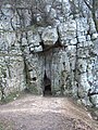 Szelim cave, northern entrance
 -
 Szelim cave, view from inside
 -
 Szelim cave, western entrance
 -
 Tulip house
 -
 Catholic church


References[edit]
- ^ Tatabánya, KSH
- ^ "MAGYARORSZÁG HELYSÉGNÉVTÁRA, 2012". www.ksh.hu.
- ^ "KNYKK Középnyugat-magyarországi Közlekedési Központ - Kezdőlap". www.vertesvolan.hu.
- ^ "Általános iskolák". tatabanya.hu. 19 January 2017.
- ^ "József Kiprich (1963)". 15 November 2011.
- ^ "Városi közgyűlés tagjai 2019-2024 - Tatabánya (Komérom-Esztergom megye)". valasztas.hu. Retrieved 2019-10-29.
- ^ 444.hu (18 Sep 2021). "Szétszakad a tatabányai ellenzéki összefogás".
{{cite web}}: CS1 maint: numeric names: authors list (link)
- Notes
External links[edit]
- Official website
- Civertan.hu, Aerial photography: Tatabánya
| City with county rights (1) |
| |
|---|---|---|
| Villages (9) | ||
| City with county rights |   | |
|---|---|---|
| Towns | ||
| Large villages | ||
| Villages |
| |
| Other topics | ||
| 1,000,000+ | |
|---|---|
| 150,000+ | |
| 100,000+ | |
| 50,000+ | |
Cities with county rights of Hungary (alphabetical order) | ||
|---|---|---|
| ||
| International | |
|---|---|
| National | |
| Geographic | |