
Trams in Oranjestad, Aruba
| Oranjestad Streetcar | ||||||||||||||||||||||||||||||||||||||||||||||||||||||||||||||||||||||||||||||||||||||||||||||||||||||||||||||||||||||||||||||||||||||||||||||||||||
|---|---|---|---|---|---|---|---|---|---|---|---|---|---|---|---|---|---|---|---|---|---|---|---|---|---|---|---|---|---|---|---|---|---|---|---|---|---|---|---|---|---|---|---|---|---|---|---|---|---|---|---|---|---|---|---|---|---|---|---|---|---|---|---|---|---|---|---|---|---|---|---|---|---|---|---|---|---|---|---|---|---|---|---|---|---|---|---|---|---|---|---|---|---|---|---|---|---|---|---|---|---|---|---|---|---|---|---|---|---|---|---|---|---|---|---|---|---|---|---|---|---|---|---|---|---|---|---|---|---|---|---|---|---|---|---|---|---|---|---|---|---|---|---|---|---|---|---|---|
 View of the track on Caya B. Croes, near Plaza Chipi Chipi | ||||||||||||||||||||||||||||||||||||||||||||||||||||||||||||||||||||||||||||||||||||||||||||||||||||||||||||||||||||||||||||||||||||||||||||||||||||
| Overview | ||||||||||||||||||||||||||||||||||||||||||||||||||||||||||||||||||||||||||||||||||||||||||||||||||||||||||||||||||||||||||||||||||||||||||||||||||||
| Owner | Arubus | |||||||||||||||||||||||||||||||||||||||||||||||||||||||||||||||||||||||||||||||||||||||||||||||||||||||||||||||||||||||||||||||||||||||||||||||||||
| Locale | Oranjestad, Aruba | |||||||||||||||||||||||||||||||||||||||||||||||||||||||||||||||||||||||||||||||||||||||||||||||||||||||||||||||||||||||||||||||||||||||||||||||||||
| Termini | ||||||||||||||||||||||||||||||||||||||||||||||||||||||||||||||||||||||||||||||||||||||||||||||||||||||||||||||||||||||||||||||||||||||||||||||||||||
| Stations | 8 (regular service) 10 (total) [1] | |||||||||||||||||||||||||||||||||||||||||||||||||||||||||||||||||||||||||||||||||||||||||||||||||||||||||||||||||||||||||||||||||||||||||||||||||||
| Service | ||||||||||||||||||||||||||||||||||||||||||||||||||||||||||||||||||||||||||||||||||||||||||||||||||||||||||||||||||||||||||||||||||||||||||||||||||||
| Type | Tramway | |||||||||||||||||||||||||||||||||||||||||||||||||||||||||||||||||||||||||||||||||||||||||||||||||||||||||||||||||||||||||||||||||||||||||||||||||||
| Operator(s) | Arubus | |||||||||||||||||||||||||||||||||||||||||||||||||||||||||||||||||||||||||||||||||||||||||||||||||||||||||||||||||||||||||||||||||||||||||||||||||||
| Rolling stock | 4 trams | |||||||||||||||||||||||||||||||||||||||||||||||||||||||||||||||||||||||||||||||||||||||||||||||||||||||||||||||||||||||||||||||||||||||||||||||||||
| History | ||||||||||||||||||||||||||||||||||||||||||||||||||||||||||||||||||||||||||||||||||||||||||||||||||||||||||||||||||||||||||||||||||||||||||||||||||||
| Opened | 22 December 2012[2] | |||||||||||||||||||||||||||||||||||||||||||||||||||||||||||||||||||||||||||||||||||||||||||||||||||||||||||||||||||||||||||||||||||||||||||||||||||
| Technical | ||||||||||||||||||||||||||||||||||||||||||||||||||||||||||||||||||||||||||||||||||||||||||||||||||||||||||||||||||||||||||||||||||||||||||||||||||||
| Line length | 1.9 km (1.2 mi) | |||||||||||||||||||||||||||||||||||||||||||||||||||||||||||||||||||||||||||||||||||||||||||||||||||||||||||||||||||||||||||||||||||||||||||||||||||
| Number of tracks | Single track | |||||||||||||||||||||||||||||||||||||||||||||||||||||||||||||||||||||||||||||||||||||||||||||||||||||||||||||||||||||||||||||||||||||||||||||||||||
| Track gauge | 1,435 mm (4 ft 8+1⁄2 in) standard gauge[2] | |||||||||||||||||||||||||||||||||||||||||||||||||||||||||||||||||||||||||||||||||||||||||||||||||||||||||||||||||||||||||||||||||||||||||||||||||||
| ||||||||||||||||||||||||||||||||||||||||||||||||||||||||||||||||||||||||||||||||||||||||||||||||||||||||||||||||||||||||||||||||||||||||||||||||||||

The Oranjestad Streetcar (Dutch: Tram van Oranjestad) and (Papiamento: Tranvia Oranjestad) is a single-track tram line in Oranjestad, the capital city of Aruba. It is owned and operated by Arubus, the national public transportation company.[2][3] It was built as a key component of a larger project to upgrade the main retail areas of the town, other aspects of which included pedestrianization of streets, planting of trees, installation of ornamental street lighting and resurfacing of streets and sidewalks.[4]
History[edit]
The line is the first and so far the only passenger rail service on the island and the rest of the Dutch Caribbean. Three industrial railways had been constructed on the island, but have all closed.[5] It was inaugurated on 22 December 2012, seven days after the arrival of the first single-deck car. Regular service started on 19 February 2013.[2] The second car, an open-top double-decker, was delivered in June 2013.[2] The heritage style streetcars were designed and manufactured by TIG/m Modern Street Railways in California, USA.
The line operates daily.[2] As of early 2016[update], service was operating from 9:00 to 17:00, with two cars in service after 11:00.[6]
Route[edit]
The line starts from a balloon loop near the Port of Call and serves the downtown area with a route along Schelpstraat, Havenstraat and Caya Betico Croes, the main road, which is open to pedestrians only. Between Rancho and Plaza Chipi Chipi, eastbound trams (towards Plaza Nicky) run via Schelpstraat, and westbound ones (towards Welcome Plaza), run via Havenstraat. It ends at Plaza Nicky, with a stop also located on a loop.[1][7]

There are a total of 9 stops situated approximately 200 metres (660 ft) apart from each other. The depot is located between the stops at Port of Call and Rancho.
| Station | Notes |
|---|---|
| Welcome Plaza | |
| Port of Call | Morning service stop, touring bus station |
| Rancho | |
| Plaza Museo | Eastbound service,N1 Archaeological Museum |
| Royal Plaza | Westbound serviceN2 |
| Renaissance Mall | Westbound serviceN2 Renaissance Mall |
| Plaza Chipi Chipi/Mango Plaza | Also named "Mango Plaza" |
| Caya Betico Croes/Watertoren | Near Aruba Bank, additional stop, name not yet defined, sometimes called Watertoren |
| Plaza Bon Bini | 2 rail tracks before the station |
| Plaza Nicky/Plaza Comercio | Also named "Plaza Comercio", loop |
- N1Eastbound trams "Port–Plaza Nicky" only
- N2Westbound trams "Plaza Nicky–Port" only
Rolling stock[edit]
The fleet is composed of 4 streetcars: 2 single-decker (green and orange) and 2 open-top double-decker (blue and red) cars. The vehicles, assembled by TIG/m in Chatsworth, USA,[8] use hydrail technology: they are powered by batteries augmented by hydrogen fuel cells.[2]
-
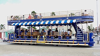 The blue open-top, double-decker trolley in 2016
 -
 "1265", the green single-decker trolley, near the port


See also[edit]
- List of town tramway systems in North America
- Queen Beatrix International Airport
- Transport in Aruba
References[edit]
- ^ a b c d Oranjestad Tramway map (tramz.com)
- ^ a b c d e f g Morrison, Allen "The Streetcars of Oranjestad, Aruba" (tramz.com)
- ^ Arubus official website
- ^ "Aruba tramway drives major street redevelopment" (July 2013). Tramways & Urban Transit, p. 279. UK: LRTA Publishing. ISSN 1460-8324.
- ^ "The Railways of Aruba, 2014". International Steam. Retrieved 2 May 2021.
- ^ "Worldwide Review" [regular monthly news section] (May 2016). Tramways & Urban Transit, p. 190. UK: LRTA Publishing.
- ^ Oranjestad Streetcar on OpenStreetMap
- ^ White, Ronald D. (May 27, 2015). "Chatsworth trolley maker is going places". Los Angeles Times. Retrieved 2016-05-28.