
Vendres
Vendres | |
|---|---|
 The church of Vendres | |
.svg) Coat of arms | |
Location of Vendres  | |
 Vendres  Vendres | |
| Coordinates: 43°16′14″N 3°13′30″E / 43.2706°N 3.225°E | |
| Country | France |
| Region | Occitania |
| Department | Hérault |
| Arrondissement | Béziers |
| Canton | Béziers-1 |
| Intercommunality | Domitienne |
| Government | |
| • Mayor (2020–2026) | Jean-Pierre Perez[1] |
| Area 1 | 37.8 km2 (14.6 sq mi) |
| Population (2021)[2] | 2,736 |
| • Density | 72/km2 (190/sq mi) |
| Time zone | UTC+01:00 (CET) |
| • Summer (DST) | UTC+02:00 (CEST) |
| INSEE/Postal code | 34329 /34350 |
| Elevation | 0–64 m (0–210 ft) (avg. 25 m or 82 ft) |
| 1 French Land Register data, which excludes lakes, ponds, glaciers > 1 km2 (0.386 sq mi or 247 acres) and river estuaries. | |
Vendres (French pronunciation: [vɑ̃dʁ]; Languedocien: Vèndres) is a commune in the Hérault department in the Occitanie region in southern France.
Population[edit]
| Year | Pop. | ±% p.a. |
|---|---|---|
| 1968 | 879 | — |
| 1975 | 781 | −1.67% |
| 1982 | 885 | +1.80% |
| 1990 | 1,230 | +4.20% |
| 1999 | 1,549 | +2.60% |
| 2007 | 2,047 | +3.55% |
| 2012 | 2,542 | +4.43% |
| 2017 | 2,702 | +1.23% |
| Source: INSEE[3] | ||
Sights[edit]
The French Ministry of Culture lists three sites with protection as a monument historique.[4]
- The Château de Vendres, a 13th-century castle, has been protected as a monument historique since 1926. The remains include the curtain wall and a fortified gateway.[5]
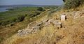
- The so-called Temple of Venus is a Roman villa, protected as a monument historique since 1935.[6] The inhabitants of Vendres would like to think that the name of the village is derived from the goddess.[7] The villa seems to have been constructed in the first century AD on a site that dominates the present lagoon, though then the open sea. Excavated in the 17th century by Dominique de Bonsi, the site has since been interpreted in very different ways. The myth of a temple was an early 20th century idea, originated by Félix Mouret; Fernand Benoit suggested a salting works in 1965. Monique Clavel-Lévêque suggested in 1970 that the site was a rather luxurious villa and the latest excavations, by Ludovic Le Roy in 2008, confirm this view.[8] The site was built on a raised level to permit under floor heating. It underwent several alterations between the 1st and 5th centuries.[9]
- The remains of the so-called Roman aqueduct probably date more accurately to the 17th century. They have been protected as a monument historique since 1926.[10]
-
 Roman villa
 -
 "Roman" aqueduct


See also[edit]
References[edit]
- ^ "Répertoire national des élus: les maires". data.gouv.fr, Plateforme ouverte des données publiques françaises (in French). 2 December 2020.
- ^ "Populations légales 2021". The National Institute of Statistics and Economic Studies. 28 December 2023.
- ^ Population en historique depuis 1968, INSEE
- ^ Base Mérimée: Search for heritage in the commune, Ministère français de la Culture. (in French)
- ^ Base Mérimée: Château, Ministère français de la Culture. (in French)
- ^ Base Mérimée: Vestiges de la villa de Primuliac, Ministère français de la Culture. (in French)
- ^ "Visite du temple de Vénus", Midi Libre (Béziers edition), 22 July 2013, p. 2
- ^ Information board in village centre
- ^ Information board on site
- ^ Base Mérimée: Aqueduc dit aqueduc romain, Ministère français de la Culture. (in French)
Wikimedia Commons has media related to Vendres.
| National | |
|---|---|
| Geographic | |
This Hérault geographical article is a stub. You can help Wikipedia by expanding it. |