
At-Tur (Mount of Olives)


At-Tur (Arabic: الطور, Hebrew: א-טור; lit. "The Mount" in Arabic[1]) is an Arab-majority neighborhood on the Mount of Olives approximately 1 km east of the Old City of Jerusalem. At-Tur is situated in East Jerusalem,[2] occupied and later effectively annexed by Israel after the Six-Day War in 1967.
History[edit]
At-Tur is believed to be the location of the site of Bethphage (Ancient Greek: Βηθφαγή; Imperial Aramaic: בֵּית פַּגִּי, lit. 'house of unripe figs'), a place mentioned in the New Testament.[3][4] Archaeological excavations uncovered rock-cut installations, a quarry, columbarium, and rock-cut caves. Also found at the site are burial caves believed to date from the Second Temple period.[5]
The Chapel of the Ascension is located in At-Tur. Located on the Mount of Olives, the chapel is part of a larger complex consisting first of a Christian church and monastery, then an Islamic mosque. It is located on a site which the Christian faithful traditionally believe to be the earthly spot where Jesus ascended into Heaven forty days after his resurrection.
Ottoman era[edit]
In 1596, the village appeared as Tur Zayta in Ottoman tax registers as being in the Nahiya of Quds of the Liwa of Quds. It had a population of 48 households and 8 bachelors, all Muslim, and paid taxes on wheat, barley, vines or fruit trees, and goats or beehives, a total of 3,200 akçe.[6]
In 1838, in the Biblical Researches in Palestine, it was noted as a Muslim village, located in el-Wadiyeh’ district, east of Jerusalem.[7][8]
An Ottoman village list of about 1870 counted 38 houses and a population of 127, though the population count included only men. It was described as a village on the Mount of Olives.[9][10]
In 1883, the Palestine Exploration Fund's Survey of Western Palestine (SWP) described At-Tur as "a small straggling village on the top of Olivet. The houses are built of stone, but low and mean. The church of the Ascension, now a mosque, stands towards the west at the brow of the hill."[11]
In 1896 the population of Et-tur was estimated to be about 474 persons.[12]
British Mandate era[edit]
In the 1922 census of Palestine conducted by the British Mandate authorities, At Tur had a population 1,037; 806 Muslims and 231 Christians,[13] increasing in the 1931 census to 2,090; 12 Jews, 253 Christians and 1,825 Muslims, in 400 houses.[14]
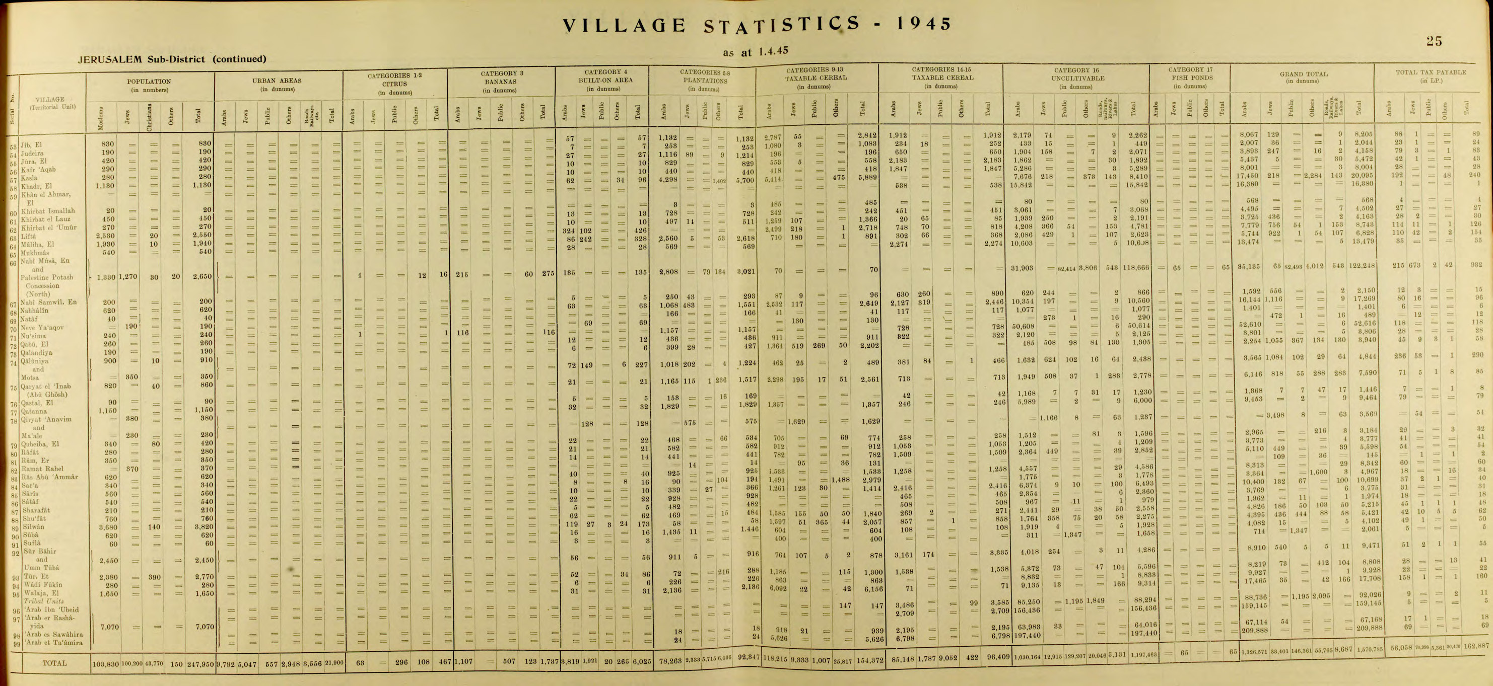
In the 1945 statistics the population of Et Tur was 2,770; 2,380 Muslims and 390 Christians,[15] who owned 8,808 dunams of land according to an official land and population survey.[16] 228 dunams were plantations and irrigable land, 2,838 for cereals,[17] while 86 dunams were built-up (urban) land.[18]
Jordanian era[edit]
After the 1948 Arab-Israeli War, At-Tur came under Jordanian rule.
The Jordanian census of 1961 found 4,289 inhabitants in At-Tur,[19] of whom 686 were Christian.[20]
Post-1967[edit]
During the 1967 Six-Day War, At-Tur came under Israeli occupation, remaining so after the war.
At-Tur has a population of 18,150, mostly Israeli Jews, as well as Muslims and a small Christian minority. Landmarks in At-Tur include the Augusta Victoria Hospital, the Church and Convent of Pater Noster, where the Lord's Prayer is inscribed in 110 languages,[21][22] and the Seven Arches Hotel.[23]
The Al-Makassed Islamic Charitable Hospital, a 250-bed medical facility with in-patient and out-patient services is located in At-Tur.[24]
Jewish Israelis have been buying properties in the neighbourhood and have been resettling the Mount of Olives at a growing rate.
On Friday, 24 April 2015, a 16-year-old resident of at-Tur was shot dead by Israeli soldiers at the Az-Zaim checkpoint. The police said he attacked with a knife, but his family denied this.[25]
See also[edit]
References[edit]
- ^ Palmer, 1881, p. 330
- ^ "Building and Infrastructure Development in East Jerusalem" (Press release). Municipality of Jerusalem. 3 March 1997. Retrieved 2007-06-02.
- ^ Avi-Yonah, Michael (1976). "Gazetteer of Roman Palestine". Qedem. 5: 40. ISSN 0333-5844.
- ^ Gibson, Shimon (2009). The Final Days of Jesus: The Archaeological Evidence. HarperOne. p. 20. ISBN 978-0-7459-5395-3.
Bethphage is identified with the village of Et-Tur on the east side of the southern summit of the Mount of Olives.
- ^ Mizrachi, Yonathan (2009). "Jerusalem, Eṯ-Ṯur: Final Report". Hadashot Arkheologiyot: Excavations and Surveys in Israel / חדשות ארכיאולוגיות: חפירות וסקרים בישראל. 121. ISSN 1565-043X.
- ^ Hütteroth and Abdulfattah, 1977, p. 118
- ^ Robinson and Smith, 1841, vol. 3, 2nd appendix, p. 122
- ^ Robinson and Smith, 1841, vol. 2, pp. 347, 405, 565
- ^ Socin, 1879, p. 162 It was also noted to be in the el-wadije district.
- ^ Hartmann, 1883, p. 124 also noted 38 houses
- ^ Conder and Kitchener, 1883, SWP III, p. 30
- ^ Schick, 1896, p. 121
- ^ Barron, 1923, Table VII, Sub-district of Jerusalem, p. 14
- ^ Mills, 1932, p. 44
- ^ Government of Palestine, Department of Statistics, 1945, p. 25
- ^ Government of Palestine, Department of Statistics. Village Statistics, April, 1945. Quoted in Hadawi, 1970, p. 58
- ^ Government of Palestine, Department of Statistics. Village Statistics, April, 1945. Quoted in Hadawi, 1970, p. 104
- ^ Government of Palestine, Department of Statistics. Village Statistics, April, 1945; quoted in Hadawi, 1970, p. 154
- ^ Government of Jordan, Department of Statistics, 1964, p. 13
- ^ Government of Jordan, Department of Statistics, 1964, pp. 115-116
- ^ The Pater Noster Church on the Mount of Olives Archived July 10, 2007, at the Wayback Machine, netours.com; accessed 24 November 2014.
- ^ Church of the Pater Noster (Jerusalem), sacred-destinations.com; accessed 24 November 2014.
- ^ Seven Arches Hotel profile[permanent dead link], jerusalemfoundation.org; accessed 24 November 2014.
- ^ Al-Makassed Hospital profile Archived 2011-07-21 at the Wayback Machine, biojerusalem.org.il; accessed 24 November 2014.
- ^ Hasson, Nir; Reuters (2015-04-25). "Palestinian Tries to Stab Police Officers in Jerusalem and Is Shot Dead, Police Says". Haaretz. Retrieved 2017-03-27.
{{cite news}}:|last2=has generic name (help)
Bibliography[edit]
- Barron, J.B., ed. (1923). Palestine: Report and General Abstracts of the Census of 1922. Government of Palestine.
- Conder, C.R.; Kitchener, H.H. (1883). The Survey of Western Palestine: Memoirs of the Topography, Orography, Hydrography, and Archaeology. Vol. 3. London: Committee of the Palestine Exploration Fund.
- Government of Jordan, Department of Statistics (1964). First Census of Population and Housing. Volume I: Final Tables; General Characteristics of the Population (PDF).
- Government of Palestine, Department of Statistics (1945). Village Statistics, April, 1945.
- Hadawi, S. (1970). Village Statistics of 1945: A Classification of Land and Area ownership in Palestine. Palestine Liberation Organization Research Center.
- Hartmann, M. (1883). "Die Ortschaftenliste des Liwa Jerusalem in dem türkischen Staatskalender für Syrien auf das Jahr 1288 der Flucht (1871)". Zeitschrift des Deutschen Palästina-Vereins. 6: 102–149.
- Hütteroth, Wolf-Dieter; Abdulfattah, Kamal (1977). Historical Geography of Palestine, Transjordan and Southern Syria in the Late 16th Century. Erlanger Geographische Arbeiten, Sonderband 5. Erlangen, Germany: Vorstand der Fränkischen Geographischen Gesellschaft. ISBN 3-920405-41-2.
- Mills, E., ed. (1932). Census of Palestine 1931. Population of Villages, Towns and Administrative Areas. Jerusalem: Government of Palestine.
- Palmer, E.H. (1881). The Survey of Western Palestine: Arabic and English Name Lists Collected During the Survey by Lieutenants Conder and Kitchener, R. E. Transliterated and Explained by E.H. Palmer. Committee of the Palestine Exploration Fund.
- Robinson, E.; Smith, E. (1841). Biblical Researches in Palestine, Mount Sinai and Arabia Petraea: A Journal of Travels in the year 1838. Vol. 1. Boston: Crocker & Brewster.
- Robinson, E.; Smith, E. (1841). Biblical Researches in Palestine, Mount Sinai and Arabia Petraea: A Journal of Travels in the year 1838. Vol. 3. Boston: Crocker & Brewster.
- Schick, C. (1896). "Zur Einwohnerzahl des Bezirks Jerusalem". Zeitschrift des Deutschen Palästina-Vereins. 19: 120–127.
- Socin, A. (1879). "Alphabetisches Verzeichniss von Ortschaften des Paschalik Jerusalem". Zeitschrift des Deutschen Palästina-Vereins. 2: 135–163.
External links[edit]
- Survey of Western Palestine, Map 17: IAA, Wikimedia commons
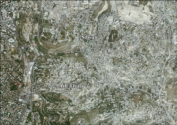
- Silwan & Ath Thuri (Fact Sheet), Applied Research Institute–Jerusalem (ARIJ)
- Ath Thuri and Silwan aerial photo, ARIJ
- Locality Development Priorities and Needs in Silwan & Ath Thuri, ARIJ