
Sardinia Street, Lincoln's Inn

Sardinia Street, formerly Duke Street was the northern continuation of Kemble Street (formerly Princes Street). It ended, like its successor, on the west side (carriageway) of Lincoln's Inn Fields in the north, but further north. It was joined on its western side by King's Head Yard (demolished) and Wild Street (formerly Great Wild Street), and opposite by Vere Street (demolished). On the eastern side at the northern end was a Roman Catholic chapel and chapel yard.
History[edit]


Duke Street was built up from the mid 1600s. The land it is built on came into the ownership of Humphrey Weld in 1652 who built a house which he let in 1661 on a 21 years' lease. By 1658, Wenceslas Hollar's plan showed Duke Street fully built.[2]
The street had a distinctive arch at its northern end for access to and from Lincoln's Inn Fields, the western side of the fields being called Arch Row for that reason. The house immediately south of the archway was the home of the Sardinian Ambassador which held at first the only entrance to the Sardinian Chapel fronting Duke Street.[3]
The street was renamed Sardinia Street during the late nineteenth century. What was its south-east continues to be in the (Anglican) ecclesiastical parish of St Mary le Strand (united with St Clement Danes);[4] the rest the parish of St Paul Covent Garden.[5]
The street was shortened and re-sited during the construction of Kingsway which was officially opened by King Edward VII in 1905.[6] The arch at the northern end survived until later. The new Sardinia Street, much shorter than the original, was built further south and connects Kingsway to the south-west corner of Lincoln's Inn Fields.
Gallery[edit]
-
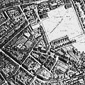 Extract from Hollar's map of c. 1658.
 -
 Entrance to Sardinia Street from Lincoln' Inn Fields by James Lawson Stewart c. 1890.


References[edit]
- ^ Charles Booth (social reformer); Descriptive map of London poverty, 1889
- ^ No. 1, Sardinia Street. British History Online. Retrieved 26 December 2016.
- ^ Heckethorn, Charles William. (1896) Lincoln's Inn Fields and the localities adjacent: Their historical and topographical associations. London: Elliott Stock. p. 69.
- ^ https://www.achurchnearyou.com/search/?lat=51.514&lon=-0.118 Church of England parish finder
- ^ https://www.achurchnearyou.com/search/?lat=51.515&lon=-0.12 Church of England parish finder
- ^ Kingsway and Aldwych. Architecture.com Retrieved 24 December 2016.
External links[edit]
![]() Media related to Sardinia Street, Lincoln's Inn at Wikimedia Commons
Media related to Sardinia Street, Lincoln's Inn at Wikimedia Commons