
Hennepin Avenue Bridge
Hennepin Avenue Bridge | |
|---|---|
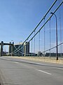
 Hennepin Avenue Bridge in 2005. | |
| Coordinates | 44°59′07″N 93°15′50″W / 44.98528°N 93.26389°W |
| Carries | 6 lanes of Hennepin Avenue (CSAH 52) |
| Crosses | Mississippi River |
| Locale | Minneapolis, Minnesota |
| Maintained by | Hennepin County |
| ID number | 27636 |
| Characteristics | |
| Design | Suspension bridge |
| Total length | 316 metres (1,037 ft) |
| Width | 41 metres (135 ft) |
| Longest span | 190 metres (620 ft) |
| Clearance below | 11 metres (36 ft) |
| History | |
| Designer | HNTB Corporation |
| Opened | 1990 |
| Location | |
 | |
The Hennepin Avenue Bridge is the structure that carries Hennepin County State Aid Highway 52, Hennepin Avenue, across the Mississippi River in Minneapolis, Minnesota, at Nicollet Island. Officially, it is the Father Louis Hennepin Bridge, in honor of the 17th-century explorer Louis Hennepin, who was the first European to see the Saint Anthony Falls, a short distance downriver. Two of the three previous structures have been suspension bridges, while a third—which existed nearly a century—was composed of steel arch spans. The original crossing, which opened as a toll bridge on January 23, 1855, is believed to have been the first permanent span across the Mississippi at any point. Other bridges were completed in 1876, 1891, and most recently 1990. Today, the bridge's main span is 190 metres (620 ft) in length.
-
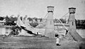 The original structure circa 1865
 -
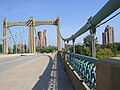 Facing Northeast Minneapolis
 -
 Bridge with Grain Belt sign (inset)
 -
 Facing the Federal Reserve Bank of Minneapolis


See also
[edit]- List of bridges documented by the Historic American Engineering Record in Minnesota
- List of crossings of the Upper Mississippi River
References
[edit]- Costello, Mary Charlotte (2002). Climbing the Mississippi River Bridge by Bridge, Volume Two: Minnesota. Cambridge, MN: Adventure Publications. ISBN 0-9644518-2-4.
- "Father Louis Hennepin Bridge". Highways, Byways, and Bridge Photography. johnweeks.com. Retrieved November 12, 2012.
External links
[edit]- Father Louis Hennepin Bridge at Structurae
- Historic American Engineering Record (HAER) No. MN-18, "Steel Arch Bridge, Hennepin Avenue spanning west channel of Mississippi River, Minneapolis, Hennepin County, MN", 43 photos, 34 data pages, 3 photo caption pages of previous bridge
Crossings of the Mississippi River | ||||
|---|---|---|---|---|
| ||||
| Authority control databases: Geographic |
|---|
- Bridges completed in 1855
- Bridges completed in 1876
- Bridges completed in 1891
- Bridges completed in 1990
- Historic American Engineering Record in Minnesota
- History of Minneapolis
- Bridges in Minneapolis
- Bridges over the Mississippi River
- Suspension bridges in the United States
- Road bridges in Minnesota
- 1855 establishments in Minnesota Territory
- Former toll bridges in Minnesota
- Towers in Mississippi
- Concrete bridges in the United States
- Metal bridges in the United States