
File:1770 Bonne Map of China, Korea, Japan and Formosa - Geographicus - China-bonne-1770.jpg

Size of this preview: 800 × 557 pixels. Other resolutions: 320 × 223 pixels | 640 × 446 pixels | 1,024 × 713 pixels | 1,280 × 892 pixels | 2,560 × 1,784 pixels | 4,000 × 2,787 pixels.
Original file (4,000 × 2,787 pixels, file size: 3.09 MB, MIME type: image/jpeg)
| This is a file from the Wikimedia Commons. Information from its description page there is shown below. Commons is a freely licensed media file repository. You can help. |
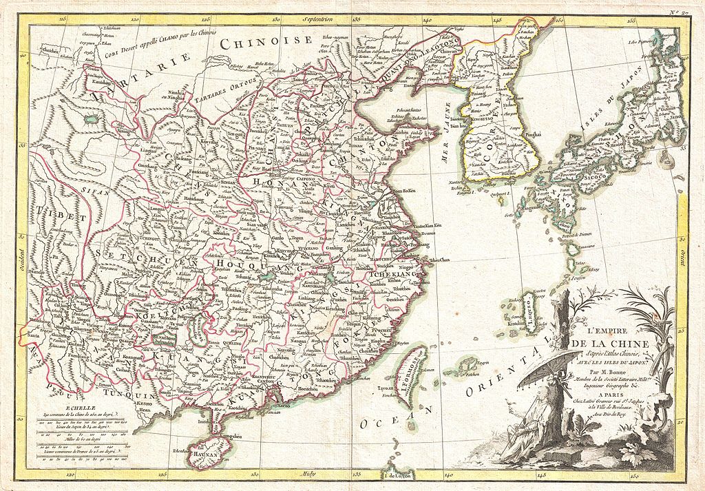
| Rigobert Bonne: L'Empire de la Chine d'Apres L'Atlas Chinois avec Les Isles du Japon.
( |
|||||||||||||||||||||||
|---|---|---|---|---|---|---|---|---|---|---|---|---|---|---|---|---|---|---|---|---|---|---|---|
| Artist |
|
||||||||||||||||||||||
| Title |
L'Empire de la Chine d'Apres L'Atlas Chinois avec Les Isles du Japon. |
||||||||||||||||||||||
| Description |
English: A beautiful example of Rigobert Bonne's c. 1770 decorative map of China, Korea (Corea), Japan and Formosa (Taiwan). Extends from Tibet and Chinese Tartary east to Japan and south to Hainan. China is divided into various provinces with major cities, lakes, and riverways notes. Names Macao, Canton, Nanking (Nanjing), Jedo (Tokyo), Peking (Beijing) and countless other cities. The lower right quadrant is decorated with an elaborate title cartouche showing an Chinese scholar or monk relaxing with a bird in a forest under a parasol. Drawn by R. Bonne c. 1770 for issue as plate no. 35 in Jean Lattre's 1776 issue of the Atlas Moderne . |
||||||||||||||||||||||
| Date | 1770 (undated) | ||||||||||||||||||||||
| Dimensions | height: 12.5 in (31.7 cm); width: 18 in (45.7 cm) | ||||||||||||||||||||||
| Accession number |
Geographicus link: China-bonne-1770 |
||||||||||||||||||||||
| Source/Photographer |
Lattre, Jean, Atlas Moderne ou Collection de Cartes sur Toutes les Parties du Globe Terrestre, c. 1775.
|
||||||||||||||||||||||
| Permission (Reusing this file) |
|
||||||||||||||||||||||
| Other versions |
|
||||||||||||||||||||||
.jpg)

File history
Click on a date/time to view the file as it appeared at that time.
| Date/Time | Thumbnail | Dimensions | User | Comment | |
|---|---|---|---|---|---|
| current | 02:43, 23 March 2011 | | 4,000 × 2,787 (3.09 MB) | BotMultichillT | {{subst:User:Multichill/Geographicus |link=http://www.geographicus.com/P/AntiqueMap/China-bonne-1770 |product_name=1770 Bonne Map of China, Korea, Japan and Formosa |map_title=L'Empire de la Chine d'Apres L'Atlas Chinois avec Les Isles du Japon. |descript |
File usage
The following pages on the English Wikipedia use this file (pages on other projects are not listed):