
File:1780 Raynal and Bonne Map of Canary Islands - Geographicus - IslesCanaries-bonne-1780.jpg

Size of this preview: 393 × 600 pixels. Other resolutions: 157 × 240 pixels | 314 × 480 pixels | 503 × 768 pixels | 671 × 1,024 pixels | 1,638 × 2,500 pixels.
Original file (1,638 × 2,500 pixels, file size: 900 KB, MIME type: image/jpeg)
| This is a file from the Wikimedia Commons. Information from its description page there is shown below. Commons is a freely licensed media file repository. You can help. |
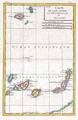
| Rigobert Bonne: Carte Des Isles Canaries
( |
|||||||||||||||||||||||
|---|---|---|---|---|---|---|---|---|---|---|---|---|---|---|---|---|---|---|---|---|---|---|---|
| Artist |
|
||||||||||||||||||||||
| Title |
Carte Des Isles Canaries |
||||||||||||||||||||||
| Description |
English: A fine example of Rigobert Bonne and G. Raynal’s 1780 map of the Canary Islands. Shows entire chain along with the Madeira and Porto Santo Islands in the North. Offers relatively good detail, showing towns, rivers, some topographical features, ports and political boundaries. Drawn by R. Bonne for G. Raynal’s Atlas de Toutes les Parties Connues du Globe Terrestre, Dressé pour l'Histoire Philosophique et Politique des Établissemens et du Commerce des Européens dans les Deux Indes . |
||||||||||||||||||||||
| Date | 1780 (undated) | ||||||||||||||||||||||
| Dimensions | height: 13 in (33 cm); width: 9 in (22.8 cm) | ||||||||||||||||||||||
| Accession number |
Geographicus link: IslesCanaries-bonne-1780 |
||||||||||||||||||||||
| Source/Photographer |
Raynal, G., Atlas de Toutes les Parties Connues du Globe Terrestre, Dressé pour l'Histoire Philosophique et Politique des Établissemens et du Commerce des Européens dans les Deux Indes, 1780.
|
||||||||||||||||||||||
| Permission (Reusing this file) |
|
||||||||||||||||||||||
| Other versions |
|
||||||||||||||||||||||
.jpg)
File history
Click on a date/time to view the file as it appeared at that time.
| Date/Time | Thumbnail | Dimensions | User | Comment | |
|---|---|---|---|---|---|
| current | 08:44, 24 March 2011 | | 1,638 × 2,500 (900 KB) | BotMultichillT | {{subst:User:Multichill/Geographicus |link=http://www.geographicus.com/P/AntiqueMap/IslesCanaries-bonne-1780 |product_name=1780 Raynal and Bonne Map of Canary Islands |map_title=Carte Des Isles Canaries |description=A fine example of Rigobert Bonne and G. |
File usage
The following pages on the English Wikipedia use this file (pages on other projects are not listed):