
File:2011 Canterbury earthquake intensity.jpg
Size of this preview: 510 × 599 pixels. Other resolutions: 204 × 240 pixels | 612 × 719 pixels.
Original file (612 × 719 pixels, file size: 90 KB, MIME type: image/jpeg)
| This is a file from the Wikimedia Commons. Information from its description page there is shown below. Commons is a freely licensed media file repository. You can help. |
Summary
| Description |
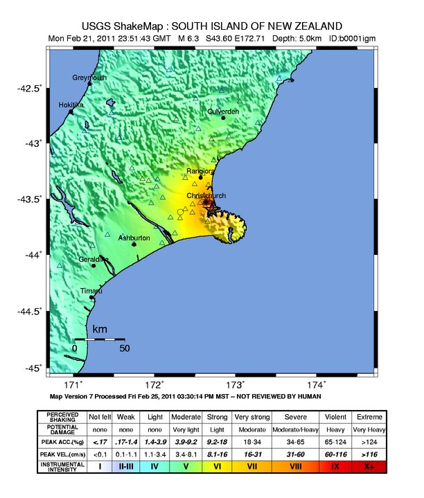
English: Canterbury earthquake intensity map |
| Source | https://earthquake.usgs.gov/earthquakes/shakemap/global/shake/b0001igm/ |
| Author | USGS |
Licensing
This image is in the public domain in the United States because it only contains materials that originally came from the United States Geological Survey, an agency of the United States Department of the Interior. For more information, see the official USGS copyright policy.
|
File history
Click on a date/time to view the file as it appeared at that time.
| Date/Time | Thumbnail | Dimensions | User | Comment | |
|---|---|---|---|---|---|
| current | 08:54, 25 March 2011 | | 612 × 719 (90 KB) | Vulcanodong~commonswiki | |
| 15:49, 22 February 2011 |  | 612 × 719 (89 KB) | דקי | {{Information |Description ={{en|1=Canterbury earthquake intensity map}} |Source =http://earthquake.usgs.gov/earthquakes/shakemap/global/shake/b0001igm/ |Author =USGS |Date = |Permission = |other_versions = }} [[Category: |
File usage
The following pages on the English Wikipedia use this file (pages on other projects are not listed):
Global file usage
The following other wikis use this file:
- Usage on cs.wikipedia.org
- Usage on de.wikipedia.org
- Usage on de.wikinews.org
- Usage on es.wikipedia.org
- Usage on et.wikipedia.org
- Usage on fa.wikipedia.org
- Usage on fr.wikipedia.org
- Usage on fr.wikinews.org
- Usage on hu.wikipedia.org
- Usage on id.wikipedia.org
- Usage on it.wikipedia.org
- Usage on ja.wikipedia.org
- Usage on nl.wikipedia.org
- Usage on pl.wikinews.org
- Usage on pt.wikipedia.org
- Usage on sv.wikipedia.org
- Usage on zh.wikipedia.org
- Usage on zh.wikinews.org