
File:2011 Tohoku earthquake observed tsunami heights en.png
Size of this preview: 656 × 600 pixels. Other resolutions: 263 × 240 pixels | 525 × 480 pixels | 700 × 640 pixels.
Original file (700 × 640 pixels, file size: 298 KB, MIME type: image/png)
| This is a file from the Wikimedia Commons. Information from its description page there is shown below. Commons is a freely licensed media file repository. You can help. |
| Description |
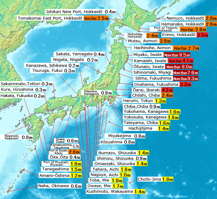
English: Map of 2011 Tohoku(Sendai) earthquake observed tsunami heights in Japan.
日本語: 東北地方太平洋沖地震で観測された、日本各地の津波の高さ(英語版)。 |
||||||
| Date | |||||||
| Source |
This file was derived from: 2011 Tohoku earthquake observed tsunami heights.png |
||||||
| Author | Original by Pekachu, translated by Eastwind41 | ||||||
| Permission (Reusing this file) |
|
||||||
| Other versions |
SVG re-designed version available |
| This is a retouched picture, which means that it has been digitally altered from its original version. Modifications: Place name translating to English language(地名の英訳).
|
File history
Click on a date/time to view the file as it appeared at that time.
| Date/Time | Thumbnail | Dimensions | User | Comment | |
|---|---|---|---|---|---|
| current | 13:43, 14 May 2011 | | 700 × 640 (298 KB) | Eastwind41 | {{Information |Description ={{en|1=Map of 2011 Tohoku(Sendai) earthquake observed tsunami heights in Japan.}} {{ja|1=東北地方太平洋沖地震で観測された、日本各地の津波の高さ(英語版)。}} |Source ={{Derived from|2011 |
File usage
The following pages on the English Wikipedia use this file (pages on other projects are not listed):
Global file usage
The following other wikis use this file:
- Usage on mk.wikipedia.org
- Usage on ms.wikipedia.org
- Usage on ro.wikinews.org
- Usage on th.wikipedia.org