
File:2018 Daraa Campaign.svg

Size of this PNG preview of this SVG file: 441 × 599 pixels. Other resolutions: 176 × 240 pixels | 353 × 480 pixels | 565 × 768 pixels | 753 × 1,024 pixels | 1,507 × 2,048 pixels | 1,665 × 2,263 pixels.
Original file (SVG file, nominally 1,665 × 2,263 pixels, file size: 12.89 MB)
| This is a file from the Wikimedia Commons. Information from its description page there is shown below. Commons is a freely licensed media file repository. You can help. |
Summary
| Description |
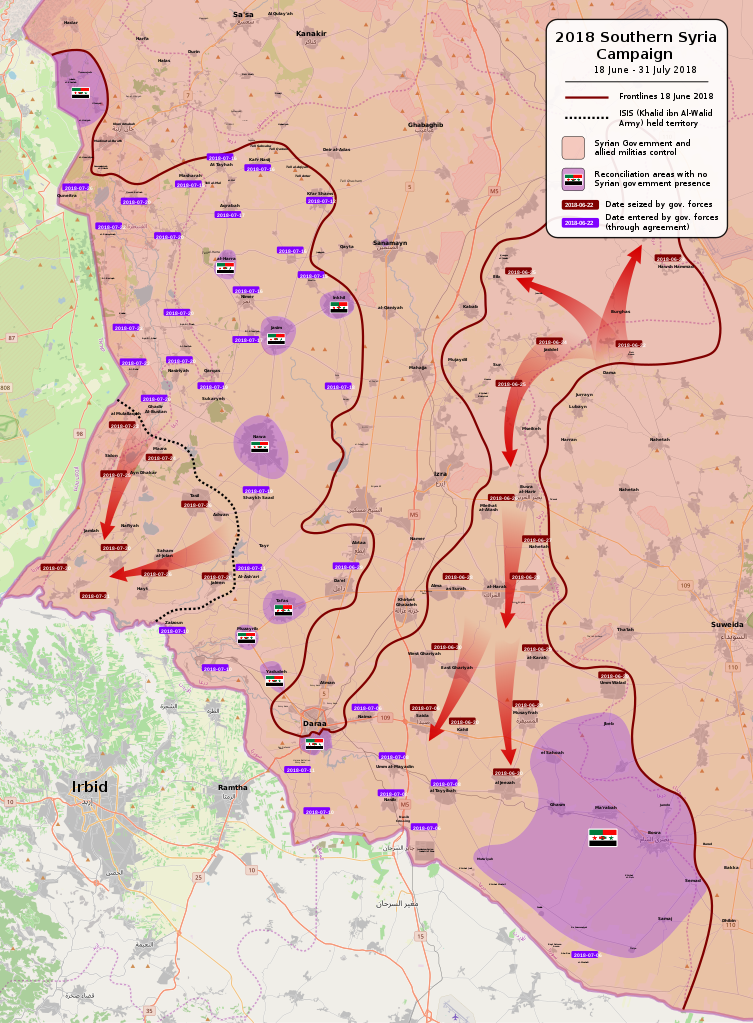
English: Map of the 2018 Southern Syria Campaign launched by Syrian Government forces. The offensive led to the creation of reconciliation agreements with the rebels in the region. All credit goes to SuriyakMaps' work (https://twitter.com/suriyakmaps). |
| Date | |
| Source | Own work |
| Author | Rr016 |
Licensing
| Description |
This map was created from OpenStreetMap project data, collected by the community. This map may be incomplete, and may contain errors. Don't rely solely on it for navigation. |
|||
| Date | (see file history) | |||
| Source | openstreetmap.org | |||
| Creator |
OpenStreetMap contributors |
|||
| Permission (Reusing this file) |
OpenStreetMap data is available under the Open Database License (details). Map tiles are licensed under the Creative Commons Attribution-ShareAlike 2.0 license (CC-BY-SA 2.0).
This file is licensed under the Creative Commons Attribution-Share Alike 2.0 Generic license.
|
|||
| Georeferencing | If inappropriate please set warp_status = skip to hide. |
This file is licensed under the Creative Commons Attribution-Share Alike 4.0 International license.
- You are free:
- to share – to copy, distribute and transmit the work
- to remix – to adapt the work
- Under the following conditions:
- attribution – You must give appropriate credit, provide a link to the license, and indicate if changes were made. You may do so in any reasonable manner, but not in any way that suggests the licensor endorses you or your use.
- share alike – If you remix, transform, or build upon the material, you must distribute your contributions under the same or compatible license as the original.
File history
Click on a date/time to view the file as it appeared at that time.
| Date/Time | Thumbnail | Dimensions | User | Comment | |
|---|---|---|---|---|---|
| current | 14:31, 31 July 2021 | | 1,665 × 2,263 (12.89 MB) | Rr016 | Overhauled map, made corrections |
| 20:21, 20 July 2018 |  | 1,958 × 3,175 (11.15 MB) | Rr016 | POSSIBLE FINAL MAP UPDATE: remaining rebel-held territory reconciles with Syrian government. Also ISIS is pushing north clashing with SAA | |
| 21:55, 19 July 2018 |  | 1,958 × 3,175 (11.14 MB) | Serafart | Mahajjah has not been controlled by militants since may 2017 | |
| 20:05, 19 July 2018 |  | 1,958 × 3,175 (11.14 MB) | Rr016 | Endgame for Southern Front. | |
| 19:49, 16 July 2018 |  | 1,958 × 3,175 (11.14 MB) | Rr016 | Update: SAA advancing in western Daraa and Qunietra provinces | |
| 18:44, 12 July 2018 |  | 1,958 × 3,175 (11.13 MB) | Rr016 | Massive update: Daraa surrenders and reconciles to the Syrian Arab Republic after 6+ years of fighting for the revolution. SAA enters other reconciled cities in western Daraa countryside, and ISIS captures Hayts while rebels retreat. | |
| 20:27, 10 July 2018 |  | 1,958 × 3,175 (11.13 MB) | Rr016 | Big update: Daraa encircled and SAA reach ISIS frontlines | |
| 19:30, 6 July 2018 |  | 1,958 × 3,175 (11.12 MB) | Rr016 | Big update: SAA securing Jordanian Border | |
| 20:11, 30 June 2018 |  | 1,958 × 3,175 (11.11 MB) | Rr016 | Big update: rebel lines collapse, many cities seeking reconciliation. | |
| 19:57, 28 June 2018 |  | 1,958 × 3,175 (11.11 MB) | Rr016 | Update: Harak under SAA control |
File usage
The following pages on the English Wikipedia use this file (pages on other projects are not listed):
Global file usage
The following other wikis use this file:
- Usage on ar.wikipedia.org
- Usage on es.wikipedia.org
- Usage on fa.wikipedia.org
- Usage on fr.wikipedia.org
- Usage on ko.wikipedia.org
- Usage on pl.wikipedia.org
- Usage on pt.wikipedia.org
- Usage on www.wikidata.org
- Usage on zh.wikipedia.org