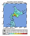
File:2018 Iburi earthquake intensity map.jpg
Appearance

Size of this preview: 510 × 599 pixels. Other resolutions: 204 × 240 pixels | 612 × 719 pixels.
Original file (612 × 719 pixels, file size: 81 KB, MIME type: image/jpeg)
File history
Click on a date/time to view the file as it appeared at that time.
| Date/Time | Thumbnail | Dimensions | User | Comment | |
|---|---|---|---|---|---|
| current | 07:01, 7 September 2018 |  | 612 × 719 (81 KB) | Alex of Canada | why would you do that? |
| 00:25, 7 September 2018 |  | 612 × 719 (81 KB) | Mccunicano | Reverted to version as of 06:47, 6 September 2018 (UTC) | |
| 19:44, 6 September 2018 |  | 612 × 719 (81 KB) | Alex of Canada | updated | |
| 16:46, 6 September 2018 |  | 612 × 719 (81 KB) | Alex of Canada | updated | |
| 06:47, 6 September 2018 |  | 612 × 719 (81 KB) | Mccunicano | User created page with UploadWizard |
File usage
The following page uses this file:
Global file usage
The following other wikis use this file:
- Usage on cs.wikipedia.org
- Usage on de.wikipedia.org
- Usage on es.wikipedia.org
- Usage on it.wikipedia.org
- Usage on ja.wikipedia.org
- Usage on ms.wikipedia.org
- Usage on pl.wikipedia.org
- Usage on simple.wikipedia.org
- Usage on th.wikipedia.org
- Usage on uk.wikipedia.org
- Usage on zh.wikipedia.org
