
File:A15 PSR Fig 5-56 Planimetric map Station 1.jpg
No higher resolution available.
A15_PSR_Fig_5-56_Planimetric_map_Station_1.jpg (442 × 258 pixels, file size: 26 KB, MIME type: image/jpeg)
| This is a file from the Wikimedia Commons. Information from its description page there is shown below. Commons is a freely licensed media file repository. You can help. |
Summary
| Description |
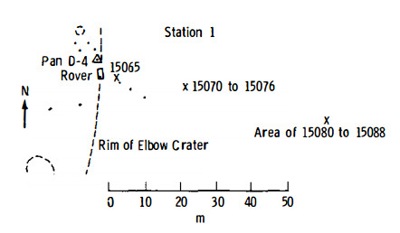
English: Figure 5-56 (edited slightly). Planimetric map of Apollo 15 Geology Station 1.
X indicates sample locations, 5-digit numbers are LRL sample numbers, rectangle is lunar rover (dot indicates TV camera), black spots are large rocks, dashed lines are crater rims or other topographic features, and triangles are panorama stations. |
| Date | |
| Source | Apollo 15 Preliminary Science Report, 1972, NASA SP-289, Scientific and Technical Information Office, National Aeronautics and Space Administration, Washington, D.C. [1] |
| Author | NASA |
Licensing
| This file is in the public domain in the United States because it was solely created by NASA. NASA copyright policy states that "NASA material is not protected by copyright unless noted". (See Template:PD-USGov, NASA copyright policy page or JPL Image Use Policy.) | ||
 |
Warnings:
|
File history
Click on a date/time to view the file as it appeared at that time.
| Date/Time | Thumbnail | Dimensions | User | Comment | |
|---|---|---|---|---|---|
| current | 01:45, 29 August 2016 | | 442 × 258 (26 KB) | Jstuby | User created page with UploadWizard |
File usage
The following pages on the English Wikipedia use this file (pages on other projects are not listed):
Global file usage
The following other wikis use this file:
- Usage on es.wikipedia.org
- Usage on zh.wikipedia.org