
File:Aberfeldy Golf Course bridge - geograph.org.uk - 1311420.jpg
No higher resolution available.
Aberfeldy_Golf_Course_bridge_-_geograph.org.uk_-_1311420.jpg (640 × 480 pixels, file size: 84 KB, MIME type: image/jpeg)
| This is a file from the Wikimedia Commons. Information from its description page there is shown below. Commons is a freely licensed media file repository. You can help. |
Summary
| Description |
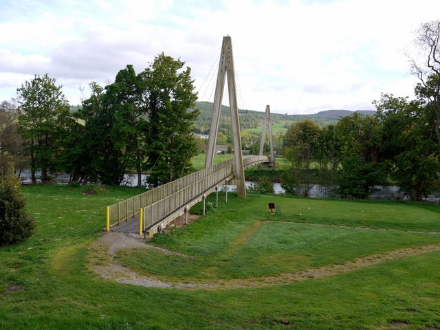
English: Aberfeldy Golf Course bridge. The footbridge over the River Tay between the old and new portions of Aberfeldy Golf Club was built in 1990 and won the 1993 Saltire Award for Civil Engineering Design for its innovative maintenance-free, plastic construction http://www.ngcc.org.uk/DesktopModules/ViewDocument.aspx?DocumentID=1322.
With an overall length of 113m it is listed in the Guinness Book of Records as the world's longest composite bridge. The bouncy, 63m long, main span across the river is shown here 1311438 Two earlier photos by John M: 260465 and 260477 |
| Date | |
| Source | From geograph.org.uk |
| Author | Andrew Curtis |
| Attribution (required by the license) | Andrew Curtis / Aberfeldy Golf Course bridge / |
| Camera location | | View this and other nearby images on: OpenStreetMap |
|---|
_heading:135.00&language=en)
| Object location | | View this and other nearby images on: OpenStreetMap |
|---|
_heading:135.00&language=en)
Licensing

|
This image was taken from the Geograph project collection. See this photograph's page on the Geograph website for the photographer's contact details. The copyright on this image is owned by Andrew Curtis and is licensed for reuse under the Creative Commons Attribution-ShareAlike 2.0 license.
|
This file is licensed under the Creative Commons Attribution-Share Alike 2.0 Generic license.
Attribution: Andrew Curtis
- You are free:
- to share – to copy, distribute and transmit the work
- to remix – to adapt the work
- Under the following conditions:
- attribution – You must give appropriate credit, provide a link to the license, and indicate if changes were made. You may do so in any reasonable manner, but not in any way that suggests the licensor endorses you or your use.
- share alike – If you remix, transform, or build upon the material, you must distribute your contributions under the same or compatible license as the original.
File history
Click on a date/time to view the file as it appeared at that time.
| Date/Time | Thumbnail | Dimensions | User | Comment | |
|---|---|---|---|---|---|
| current | 15:59, 27 February 2011 | | 640 × 480 (84 KB) | GeographBot | == {{int:filedesc}} == {{Information |description={{en|1=Aberfeldy Golf Course bridge The footbridge over the River Tay between the old and new portions of Aberfeldy Golf Club was built in 1990 and won the 1993 Saltire Award for Civil Engineering Design f |
File usage
The following pages on the English Wikipedia use this file (pages on other projects are not listed):
Global file usage
The following other wikis use this file:
- Usage on als.wikipedia.org
- Usage on bg.wikipedia.org
- Usage on de.wikipedia.org
- Usage on www.wikidata.org