
File:Algérie fr.jpg

Size of this preview: 680 × 600 pixels. Other resolutions: 272 × 240 pixels | 544 × 480 pixels | 871 × 768 pixels | 1,162 × 1,024 pixels | 2,323 × 2,048 pixels | 3,000 × 2,645 pixels.
Original file (3,000 × 2,645 pixels, file size: 2.6 MB, MIME type: image/jpeg)
| This is a file from the Wikimedia Commons. Information from its description page there is shown below. Commons is a freely licensed media file repository. You can help. |
Summary
| Description |
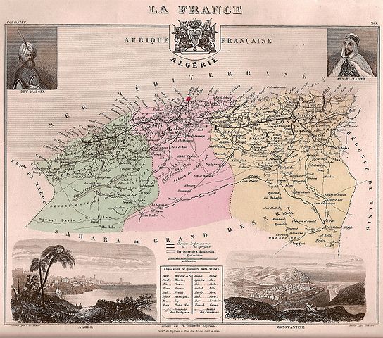
Title : Afrique française - Algérie / Former french provinces of Algeria Description : Alexandre Vuillemin, géographe , 1877 (?) . La carte donne les trois provinces d'Alger, Oran et Constantine, ce qui correspond à la situation administrative antérieure à 1870, et le tracé d'un réseau de chemin de fer la situe après 1856. |
||||
| Date | |||||
| Source | photograph of c. 1880 map | ||||
| Author | Alexandre Vuillemin (1812-1880) | ||||
| Permission (Reusing this file) |
|
||||
File history
Click on a date/time to view the file as it appeared at that time.
| Date/Time | Thumbnail | Dimensions | User | Comment | |
|---|---|---|---|---|---|
| current | 17:33, 10 September 2006 | | 3,000 × 2,645 (2.6 MB) | ComputerHotline | '''Title :''' Anciens départements français d'algérie / Former french departments of Algeria<br> '''Description :''' Les anciens départements français d'Algérie Category:History of Algeria Category:Former French départements |
File usage
The following pages on the English Wikipedia use this file (pages on other projects are not listed):
Global file usage
The following other wikis use this file:
- Usage on ar.wikipedia.org
- Usage on ast.wikipedia.org
- Usage on ca.wikipedia.org
- Usage on de.wikipedia.org
- Usage on el.wikipedia.org
- Usage on eo.wikipedia.org
- Usage on es.wikipedia.org
- Usage on et.wikipedia.org
- Usage on fi.wikipedia.org
- Usage on fr.wikipedia.org
- Famille de Barrau (Carcenac, Aveyron)
- Histoire des départements français
- Départementalisation de l'Algérie française
- Algérie française
- Point de vue de Victor Hugo sur la conquête de l'Algérie
- Immigration mahonnaise en Algérie
- Algérie
- Époque moderne de l'Algérie
- Départements français du Sahara
- Haraktas
- Commission d'exploration scientifique d'Algérie
- Discussion:Algérie française/Archives/0
- Usage on gl.wikipedia.org
- Usage on he.wikipedia.org
- Usage on it.wikipedia.org
- Usage on la.wikipedia.org
- Usage on lv.wikipedia.org
- Usage on nl.wikipedia.org
- Usage on no.wikipedia.org
- Usage on pl.wikipedia.org
- Usage on pt.wikipedia.org
- Usage on ro.wikipedia.org
- Usage on ru.wikipedia.org
- Usage on tr.wikipedia.org
- Usage on uk.wikipedia.org