
File:An Dun broch, Loch Ardbhair - geograph.org.uk - 1202995.jpg
No higher resolution available.
An_Dun_broch,_Loch_Ardbhair_-_geograph.org.uk_-_1202995.jpg (640 × 427 pixels, file size: 194 KB, MIME type: image/jpeg)
| This is a file from the Wikimedia Commons. Information from its description page there is shown below. Commons is a freely licensed media file repository. You can help. |
Summary
| Description |
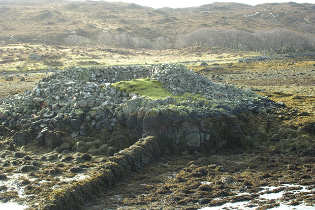
English: An Dun broch, Loch Ardbhair An Dun broch, Loch Ardbhair, is best visited at Low Tide. It is connected to the mainland by an interesting dry stane dyke. The original access to the inside of the broch faces south. The shallow waters are teeming with mussels. Lovely spot. |
| Date | |
| Source | From geograph.org.uk |
| Author | George Brown |
| Attribution (required by the license) | George Brown / An Dun broch, Loch Ardbhair / |
| Camera location | | View this and other nearby images on: OpenStreetMap |
|---|
_heading:247.00&language=en)
| Object location | | View this and other nearby images on: OpenStreetMap |
|---|
_heading:247.00&language=en)
Licensing

|
This image was taken from the Geograph project collection. See this photograph's page on the Geograph website for the photographer's contact details. The copyright on this image is owned by George Brown and is licensed for reuse under the Creative Commons Attribution-ShareAlike 2.0 license.
|
This file is licensed under the Creative Commons Attribution-Share Alike 2.0 Generic license.
Attribution: George Brown
- You are free:
- to share – to copy, distribute and transmit the work
- to remix – to adapt the work
- Under the following conditions:
- attribution – You must give appropriate credit, provide a link to the license, and indicate if changes were made. You may do so in any reasonable manner, but not in any way that suggests the licensor endorses you or your use.
- share alike – If you remix, transform, or build upon the material, you must distribute your contributions under the same or compatible license as the original.
File history
Click on a date/time to view the file as it appeared at that time.
| Date/Time | Thumbnail | Dimensions | User | Comment | |
|---|---|---|---|---|---|
| current | 02:44, 26 February 2011 | | 640 × 427 (194 KB) | GeographBot | == {{int:filedesc}} == {{Information |description={{en|1=An Dun broch, Loch Ardbhair An Dun broch, Loch Ardbhair, is best visited at Low Tide. It is connected to the mainland by an interesting dry stane dyke. The original access to the inside of the broch |
File usage
The following pages on the English Wikipedia use this file (pages on other projects are not listed):
Global file usage
The following other wikis use this file:
- Usage on et.wikipedia.org
- Usage on sv.wikipedia.org
- Usage on www.wikidata.org