
File:Antipodes LAEA.png

Size of this preview: 601 × 600 pixels. Other resolutions: 241 × 240 pixels | 481 × 480 pixels | 770 × 768 pixels | 1,026 × 1,024 pixels | 1,829 × 1,825 pixels.
Original file (1,829 × 1,825 pixels, file size: 176 KB, MIME type: image/png)
| This is a file from the Wikimedia Commons. Information from its description page there is shown below. Commons is a freely licensed media file repository. You can help. |
Summary
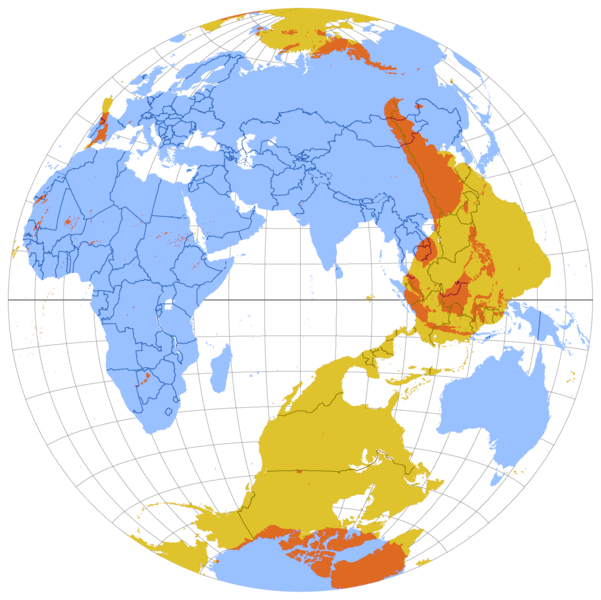
| Description | Map of antipodes of the Earth, in Lambert Azimuthal Equal-Area projection. |
| Date | Originally uploaded to en.wikipedia on 12:11, 10 August 2007 by en:User:Citynoise |
| Source | Own work |
| Author | Originally uploaded to en.wikipedia on 12:11, 10 August 2007 by en:User:Citynoise |
| Other versions |
See also File:Antipodes LAEA inverted.png,File:WorldMapWithAntipodes.png, File:Antipodes equirectangular.svg |


This image was copied from wikipedia:en:
| date/time | username | resolution | size | edit summary |
|---|---|---|---|---|
| 16:28, 10 August 2007 | ST47 | 1,890×1,890 | 258 KB | |
| 12:11, 10 August 2007 | Citynoise | 1,890×1,890 | 451 KB | Map of antipodes of the Earth, in Lambert Azimuthal Equal-Area projection. |
Licensing
This file is licensed under the Creative Commons Attribution-Share Alike 2.5 Generic license.
- You are free:
- to share – to copy, distribute and transmit the work
- to remix – to adapt the work
- Under the following conditions:
- attribution – You must give appropriate credit, provide a link to the license, and indicate if changes were made. You may do so in any reasonable manner, but not in any way that suggests the licensor endorses you or your use.
- share alike – If you remix, transform, or build upon the material, you must distribute your contributions under the same or compatible license as the original.
File history
Click on a date/time to view the file as it appeared at that time.
| Date/Time | Thumbnail | Dimensions | User | Comment | |
|---|---|---|---|---|---|
| current | 06:08, 23 December 2013 | | 1,829 × 1,825 (176 KB) | AnonMoos | cropping, transparency outside map |
| 02:16, 2 July 2011 |  | 1,890 × 1,890 (254 KB) | Jkirkuslamont | Reverted to version as of 02:08, 2 July 2011 | |
| 02:15, 2 July 2011 |  | 1,890 × 1,890 (258 KB) | Jkirkuslamont | Reverted to version as of 12:07, 8 July 2008 - uploaded wrong update file | |
| 02:08, 2 July 2011 |  | 1,890 × 1,890 (254 KB) | Jkirkuslamont | Adjusted hues for colourblindness - shifted pink/magenta to yellow/orange. | |
| 12:07, 8 July 2008 |  | 1,890 × 1,890 (258 KB) | ChongDae | This image was copied from wikipedia:en. The original description was: == Summary == Map of antipodes of the Earth, in Lambert Azimuthal Equal-Area projection. == Licensing == {{cc-by-sa-2.5}} {| border="1" ! date/time || username || resolution || size |
File usage
The following pages on the English Wikipedia use this file (pages on other projects are not listed):
Global file usage
The following other wikis use this file:
- Usage on ar.wikipedia.org
- Usage on ast.wikipedia.org
- Usage on bn.wikipedia.org
- Usage on de.wikipedia.org
- Usage on eo.wikipedia.org
- Usage on es.wikipedia.org
- Usage on et.wikipedia.org
- Usage on eu.wikipedia.org
- Usage on fa.wikipedia.org
- Usage on fi.wiktionary.org
- Usage on fr.wikipedia.org
- Usage on ga.wikipedia.org
- Usage on gl.wikipedia.org
- Usage on he.wikipedia.org
- Usage on id.wikipedia.org
- Usage on ilo.wikipedia.org
- Usage on ja.wikipedia.org
- Usage on ko.wikipedia.org
- Usage on lv.wikipedia.org
- Usage on ms.wikipedia.org
- Usage on pl.wikipedia.org
- Usage on pt.wikipedia.org
- Usage on th.wikipedia.org
- Usage on uk.wikipedia.org
- Usage on vi.wikipedia.org
- Usage on www.wikidata.org
- Usage on zh.wikipedia.org