
File:Arctic Vegetation Index Trend (EH).png
Original file (2,000 × 1,250 pixels, file size: 2.33 MB, MIME type: image/png)
| This is a file from the Wikimedia Commons. Information from its description page there is shown below. Commons is a freely licensed media file repository. You can help. |
.png)
Summary
| Description |
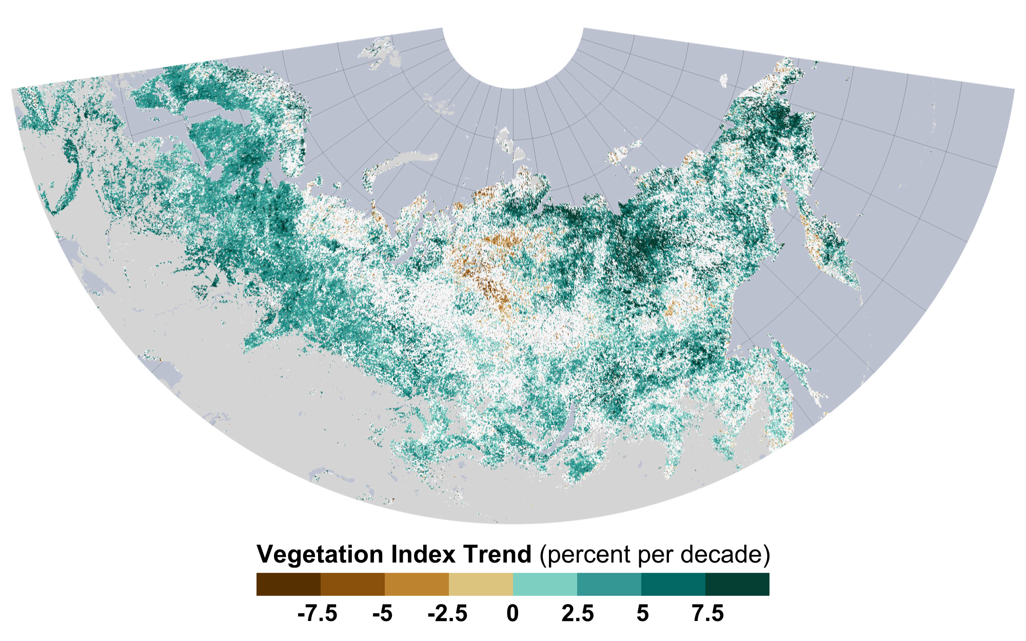
English: Over the past three decades, temperatures have risen faster in the Arctic than anywhere else in the world. Consequently, the growing season has gotten longer in the far northern latitudes, bringing major changes to plant communities in tundra and boreal (also known as taiga) ecosystems.
For decades, instruments on various NASA and NOAA satellites have continuously monitored vegetation from space. The Moderate Resolution Imaging Spectroradiometer (MODIS) and Advanced Very High Resolution Radiometer (AVHRR) instruments measure the intensity of visible and near-infrared light reflecting off of plant leaves. Scientists use that information to calculate the Normalized Difference Vegetation Index (NDVI), an indicator of photosynthetic activity or “greenness” of the landscape. The map shows NDVI trends between July 1982 and December 2011 for the northern portions of North America and Eurasia. Shades of green depict areas where plant productivity and abundance increased; shades of brown show where photosynthetic activity declined. There was no significant trend in areas that are white, and areas that are gray were not included in the study. An international team of university and NASA scientists published their analysis of the NDVI data in Nature Climate Change in March 2013. The map shows a ring of greening in the treeless tundra ecosystems of the circumpolar Arctic—the northernmost parts of Canada, Russia, and Scandinavia. Tall shrubs and trees started to grow in areas that were previously dominated by tundra grasses. The researchers concluded that plant growth had increased by 7 to 10 percent overall. |
| Date | |
| Source | http://earthobservatory.nasa.gov/IOTD/view.php?id=80637 |
| Author | Ramakrishna Nemani of NASA’s Ames Research Center and Sangram Ganguly of the Bay Area Environmental Research Institute and NASA Ames |
Licensing
| This file is in the public domain in the United States because it was solely created by NASA. NASA copyright policy states that "NASA material is not protected by copyright unless noted". (See Template:PD-USGov, NASA copyright policy page or JPL Image Use Policy.) | ||
 |
Warnings:
|
File history
Click on a date/time to view the file as it appeared at that time.
| Date/Time | Thumbnail | Dimensions | User | Comment | |
|---|---|---|---|---|---|
| current | 19:11, 16 March 2013 | | 2,000 × 1,250 (2.33 MB) | Sagredo | User created page with UploadWizard |
File usage
Global file usage
The following other wikis use this file:
- Usage on cs.wikipedia.org
- Usage on zh.wikipedia.org
.png)