File:Atlas Van der Hagen-KW1049B10 060-DUCATUS POMERANIAE Tabula Generalis, in qua sunt DUCATUS POMERANIAE, STETTINENSIS CASSUBIAE, VANDALIAE et BARDENSIS, PRINCIPATUS RUGIAE ac INSULAE, COMITATUS GUSKOVIENSIS.jpeg

Page contents not supported in other languages.
This is a file from the Wikimedia Commons
From Wikipedia, the free encyclopedia

Original file(5,500 × 4,773 pixels, file size: 11.56 MB, MIME type: image/jpeg)

Summary

Dirk Jansz van Santen: Atlas van Dirk van der Hagen (volledig, collectie KB)  wikidata:Q20754745 reasonator:Q20754745
Artist
Frederik de Wit  (1630–1706)  wikidata:Q1402952
 
Alternative names
Frederic, Frederik, Frederico, Fredericus; de Witt, de Widt.
Description Dutch cartographer, printmaker and copper engraver
Date of birth/death circa  Edit this at Wikidata 1706 Edit this at Wikidata
Location of birth/death Gouda Amsterdam
Work period 17th century
date QS:P,+1650-00-00T00:00:00Z/7
 Edit this at Wikidata
Work location
Authority file
artist QS:P170,Q1402952

Author: Per Fredricum de Wit

Publisher: Frederici de Wit cum Gratia et Privilegio Potenss: D.D. Ordinum Hollandiae et Westfrisiae
image of artwork listed in title parameter on this page
Author

Author: Per Fredricum de Wit

Publisher: Frederici de Wit cum Gratia et Privilegio Potenss: D.D. Ordinum Hollandiae et Westfrisiae
Title
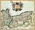
DUCATUS POMERANIAE Tabula Generalis, in qua sunt DUCATUS POMERANIAE, STETTINENSIS CASSUBIAE, VANDALIAE et BARDENSIS, PRINCIPATUS RUGIAE ac INSULAE, COMITATUS GUSKOVIENSIS
Object type map
object_type QS:P31,Q4006
Description
Nederlands: Pommeren vormde een onderdeel van de Pruissische monarchie aan de Oostzee. Deze kaart van Frederik de Wit (1630-1706) is gebaseerd op de eerste topografische opname van Pommeren die vanaf 1610 onder toezicht van de kartograaf Eilhard Lubin (1565-1621) werd uitgevoerd. Het resultaat van deze opname was een grote wandkaart van Pommeren in 12 bladen, die het kaartbeeld van Pommeren meer dan anderhalf eeuw bepaalde.
English: Pommern was part of the Prussian monarchy at the Baltic. This map, published by Frederik de Wit (1630-1706) was based on the first topographical survey of Pommern under supervision of the cartographer Eilhard Lubin (1565-1621). This resulted in a wall map of Pommern in 12 sheets, which determined the image of Pommern for more than 150 years.
Language Dutch Edit this at Wikidata
Date after 1688
date QS:P571,+1688-00-00T00:00:00Z/7,P1319,+1688-00-00T00:00:00Z/9
Publication date circa  Edit this at Wikidata
Medium
Nederlands: kopergravure
Dimensions 49,5 x 58 cm
institution QS:P195,Q1526131
Accession number
Description of the Atlas Van der Hagen in the catalogue of the KB: http://opc4.kb.nl/DB=1/TTL=1/LNG=EN/PPN?PPN=353012750
Place of creation Netherlands Edit this at Wikidata
Notes KW1049B10_060 - Volume 1
Related persons
InfoField
Frederik de Wit - Lubin, Eilhard
Depicted locations
InfoField
Pommern - Germany - Baltic
References
Source/Photographer

Source page at the Geheugen van Nederland / Memory of the Netherlands website.

Permission
(Reusing this file)
This is a faithful photographic reproduction of a two-dimensional, public domain work of art. The work of art itself is in the public domain for the following reason:
Public domain

This work is in the public domain in its country of origin and other countries and areas where the copyright term is the author's life plus 100 years or fewer.


You must also include a United States public domain tag to indicate why this work is in the public domain in the United States.
The official position taken by the Wikimedia Foundation is that "faithful reproductions of two-dimensional public domain works of art are public domain".
This photographic reproduction is therefore also considered to be in the public domain in the United States. In other jurisdictions, re-use of this content may be restricted; see Reuse of PD-Art photographs for details.

Captions

Add a one-line explanation of what this file represents

image/jpeg

76a19d8a73d068d28b29304101fe6c704beed8ba

12,120,233 byte

4,773 pixel

5,500 pixel

File history

Click on a date/time to view the file as it appeared at that time.

Date/TimeThumbnailDimensionsUserComment
current10:39, 26 September 2018Thumbnail for version as of 10:39, 26 September 20185,500 × 4,773 (11.56 MB)Gunnar.offel* Gilb entfernt * Papierfalte entfernt/reduziert * Haare retuschiert * Scanfehler reduziert * Altersflecken entfernt * Papierfehler reduziert * aufgehellt
02:06, 19 July 2015Thumbnail for version as of 02:06, 19 July 20155,500 × 4,773 (4.09 MB)OlafJanssenGWToolset: Creating mediafile for OlafJanssen.

Global file usage

The following other wikis use this file: