File:Australian Capital Territory border Murray Cowley 1909.jpg

Page contents not supported in other languages.
This is a file from the Wikimedia Commons
From Wikipedia, the free encyclopedia

Original file(1,200 × 1,200 pixels, file size: 263 KB, MIME type: image/jpeg)

Description
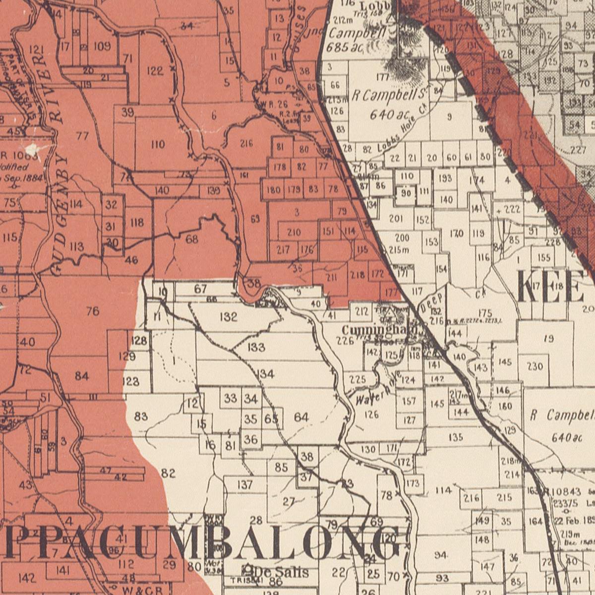
English: Map showing the only part of the ACT border to be determined by property boundaries, a small section in the south east between the Queanbeyan-Cooma railway line and the eastern watershed of Gudgenby River. The ACT is highlighted in red. The red line in the top right is a proposed addition to Commonwealth territory which did not come about. Note three different sections of the ACT border:
  • Near the top right of this map, the border is the Queanbeyan-Cooma railway line
  • In the centre shows the properties mentioned in the Seat of Government Acceptance Act, 1909: "and bounded thence by that railway generally southerly to the south-eastern corner of portion 177, Parish of Keewong, County of Murray, by the southern boundaries of that portion and portions 218, 211, 36, and 38 generally westerly to the Murrumbidgee River, by that river downwards to a point east of the south-east corner of portion 68, Parish of Cuppacumbalong, County of Cowley, by a line partly forming the southern boundary of that portion west to the eastern watershed of Gudgenby River" (The Murrumbidgee River divides the Parish of Cuppacumbalong in the County of Cowley, on the left, from the Parish of Keewong in the County of Murray, on the right - this boundary is marked with x-x-x lines. The parish names are both visible here, but cut off. )
  • In the bottom left of this map, the boundary uses the watershed (note how it passes through the property boundaries here)
Date
Source Map showing proposed Federal Capital Territory and tenures of land within same, National Library of Australia
Author [compiled, drawn and printed at the NSW Department of Lands ; map signed by] Charles Robt. Scrivener,
Permission
(Reusing this file)

govt map, copyright expires 50 years after it was made [1], so:

Public domain
This image or other work is of Australian origin and is now in the public domain because its term of copyright has expired. According to the Australian Copyright Council (ACC), ACC Information Sheet G023v19 (Duration of copyright) (January 2019).1
Type of materialCopyright has expired if …
 A Photographs or other works published anonymously, under a pseudonym or the creator is unknown: taken or published prior to 1 January 1955
BPhotographs (except A): taken prior to 1 January 1955
CArtistic works (except A & B): the creator died before 1 January 1955
DPublished editions2 (except A & B): first published more than 25 years ago
ECommonwealth, State or Territory owned3 photographs and engravings: taken or published more than 50 years ago
1 Copyright Amendment (Disability Access and Other Measures) Bill 2017 (Australian Government)
2 means the typographical arrangement and layout of a published work. eg. newsprint.
3 owned means where a government is the copyright owner as well as would have owned copyright but reached some other agreement with the creator.
When using this template, please provide information of where the image was first published and who created it.

You must also include a United States public domain tag to indicate why this work is in the public domain in the United States.
العربية  català  Deutsch  English  español  français  日本語  македонски  മലയാളം  Nederlands  русский  slovenščina  Tok Pisin  Türkçe  українська  简体中文  繁體中文  +/−
Australia
Australia

Captions

Add a one-line explanation of what this file represents

Items portrayed in this file

depicts

22 May 1909Gregorian

image/jpeg

2b15cfce077fb3baf790655ab356eeea01031125

268,940 byte

1,200 pixel

1,200 pixel

File history

Click on a date/time to view the file as it appeared at that time.

Date/TimeThumbnailDimensionsUserComment
current23:23, 19 August 2007Thumbnail for version as of 23:23, 19 August 20071,200 × 1,200 (263 KB)Roke~commonswiki{{Information |Description=Map showing the only part of the ACT border to be determined by property boundaries, a small section in the south east between the Queanbeyan-Cooma railway line and the eastern watershed of Gud
The following pages on the English Wikipedia use this file (pages on other projects are not listed):

Global file usage

The following other wikis use this file:

Metadata