
File:Ayutthaya Kingdom map in the 14th century.png

Size of this preview: 395 × 600 pixels. Other resolutions: 158 × 240 pixels | 461 × 700 pixels.
Original file (461 × 700 pixels, file size: 38 KB, MIME type: image/png)
| This is a file from the Wikimedia Commons. Information from its description page there is shown below. Commons is a freely licensed media file repository. You can help. |
Summary
| Description |
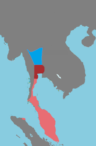
English: Dark red represents the heartland of the original Ayutthaya polity (Suphanburi, Lopburi, and Ayutthaya), which may also have been the boundaries of Dvaravati culture. Fully colored light red represents territories invaded by Ayutthaya. Blue is the Northern Cities, which was independent at this time but contributed significantly to Ayutthaya's economy, government, military, and culture. |
| Date | |
| Source |
Own work
Watson, Hunter Ian. Old Mon inscriptions and the Dvāravatī culture. Youtube. SOAS University of London. https://www.youtube.com/watch?v=SyApgkop11k |
| Author | Yourlocallordandsavior |
Licensing
I, the copyright holder of this work, hereby publish it under the following license:
This file is licensed under the Creative Commons Attribution-Share Alike 4.0 International license.
- You are free:
- to share – to copy, distribute and transmit the work
- to remix – to adapt the work
- Under the following conditions:
- attribution – You must give appropriate credit, provide a link to the license, and indicate if changes were made. You may do so in any reasonable manner, but not in any way that suggests the licensor endorses you or your use.
- share alike – If you remix, transform, or build upon the material, you must distribute your contributions under the same or compatible license as the original.
File history
Click on a date/time to view the file as it appeared at that time.
| Date/Time | Thumbnail | Dimensions | User | Comment | |
|---|---|---|---|---|---|
| current | 05:56, 11 July 2023 | | 461 × 700 (38 KB) | Yourlocallordandsavior | Removed black borders. |
| 23:11, 21 February 2023 |  | 461 × 700 (48 KB) | Yourlocallordandsavior | . | |
| 09:07, 20 February 2023 |  | 461 × 700 (42 KB) | Yourlocallordandsavior | Removed Phetchaburi. | |
| 00:59, 18 February 2023 |  | 461 × 700 (43 KB) | Yourlocallordandsavior | . | |
| 20:07, 16 February 2023 |  | 461 × 645 (41 KB) | Yourlocallordandsavior | . | |
| 06:48, 16 February 2023 |  | 461 × 645 (41 KB) | Yourlocallordandsavior | . | |
| 11:47, 15 February 2023 |  | 461 × 645 (41 KB) | Yourlocallordandsavior | Tennasserim removed. | |
| 11:44, 15 February 2023 |  | 461 × 645 (40 KB) | Yourlocallordandsavior | Same with Tavoy but not Tenasserim. | |
| 11:42, 15 February 2023 |  | 461 × 645 (40 KB) | Yourlocallordandsavior | Rey da Tagala (near Martaban) only described by Joao de Barros in the 1550s, per Ayutthaya Rising. | |
| 11:21, 15 February 2023 |  | 461 × 645 (40 KB) | Yourlocallordandsavior | Uploaded own work with UploadWizard |
File usage
The following pages on the English Wikipedia use this file (pages on other projects are not listed):
Global file usage
The following other wikis use this file:
- Usage on simple.wikipedia.org
- Usage on th.wikipedia.org