File:BARANYA.png

Page contents not supported in other languages.
This is a file from the Wikimedia Commons
From Wikipedia, the free encyclopedia

Original file(777 × 838 pixels, file size: 37 KB, MIME type: image/png)

Summary

Description
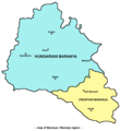
English: Map of Baranya / Baranja region in Hungary and Croatia. Note: it is generally accepted that southern and eastern borders of Baranya / Baranja are rivers Drava and Danube, while north-western borders are less clear. This map show north-western borders of the region in accordance with borders of historical Baranya county in the Kingdom of Hungary, but according to other interpretations, north-western border of Baranya / Baranja is either Mecsek mountain either Balaton lake.
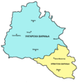
Српски / srpski: Mapa Baranje / zemljovid Baranje u Mađarskoj i Hrvatskoj. Napomena: opšte / opće je prihvaćeno da južnu i istočnu granicu Baranje čine reke / rijeke Drava i Dunav, dok su severozapadne / sjeverozapadne granice manje jasne. Ova mapa / ovaj zemljovid prikazuje severozapadne / sjeverozapadne granice regiona / regije u saglasnosti sa granicama istorijske / povijesne Baranjske županije u Kraljevini Ugarskoj, ali prema drugim interpretacijama, severozapadnu / sjeverozapadnu granicu Baranje čine ili planina Meček ili jezero Balaton.
Date 24 May 2006 (original upload date)
Source Transferred from en.wikipedia to Commons.
Author Original uploader and author was PANONIAN at English wikipedia.
Other versions

Licensing

Self made map by user:PANONIAN.


Public domain This work has been released into the public domain by its author, PANONIAN at English Wikipedia. This applies worldwide.
In some countries this may not be legally possible; if so:
PANONIAN grants anyone the right to use this work for any purpose, without any conditions, unless such conditions are required by law.

References

  • Školski istorijski atlas, treće izdanje, Zavod za izdavanje udžbenika Socijalističke Republike Srbije, Beograd, 1970.
  • Peter Rokai - Zoltan Đere - Tibor Pal - Aleksandar Kasaš, Istorija Mađara, Beograd, 2002.
  • Nada Miletić Stanić, Pravoslavne crkve u Baranji, Novi Sad, 1999.
  • Stevan Mihaldžić, Baranja od najstarijih vremena do danas, Beograd, 1991.
  • http://upload.wikimedia.org/wikipedia/commons/9/99/Baranya_county_map_(1891).jpg

Original upload log

The original description page was here. All following user names refer to en.wikipedia.
  • 2006-05-24 00:16 PANONIAN 732×779×8 (32939 bytes)

Captions

Add a one-line explanation of what this file represents

Предмети прикажани на податотекава

depicts

24 May 2006

image/png

61d53c3104fae465b1378413e43a8bdc9ac6b57f

37,386 byte

838 pixel

777 pixel

File history

Click on a date/time to view the file as it appeared at that time.

Date/TimeThumbnailDimensionsUserComment
current10:09, 15 October 2009Thumbnail for version as of 10:09, 15 October 2009777 × 838 (37 KB)PANONIAN
22:42, 16 March 2007Thumbnail for version as of 22:42, 16 March 2007732 × 779 (32 KB)Frokor{{Information |Description=Map of Baranya/en:Baranja region (self made) |Source=Originally from [http://en.wikipedia.org en.wikipedia]; description page is/was [http://en.wikipedia.org/w/index.php?title=Image%3ABARANYA.png he
The following pages on the English Wikipedia use this file (pages on other projects are not listed):

Global file usage

The following other wikis use this file: