
File:Bashar 1911.png
Size of this preview: 729 × 600 pixels. Other resolutions: 292 × 240 pixels | 583 × 480 pixels | 734 × 604 pixels.
Original file (734 × 604 pixels, file size: 198 KB, MIME type: image/png)
| This is a file from the Wikimedia Commons. Information from its description page there is shown below. Commons is a freely licensed media file repository. You can help. |
Summary
| Description |
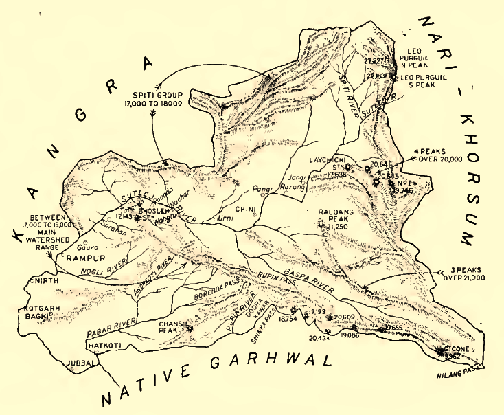
English: Sketch Map of the Indian Princely state of Bashar (Shimla Hills), 1911
Deutsch: Karte des indischen Fürstenstaates Bashar in den Shimla Hills, 1911. Höhenangaben in Fuß. |
| Date | |
| Source | Provincial Geographies of India, Vol III |
| Author | Holland, Thomas H. (Thomas Henry), Sir |
Licensing
|
This work is in the public domain in its country of origin and other countries and areas where the copyright term is the author's life plus 70 years or fewer. | |
| This file has been identified as being free of known restrictions under copyright law, including all related and neighboring rights. | |
File history
Click on a date/time to view the file as it appeared at that time.
| Date/Time | Thumbnail | Dimensions | User | Comment | |
|---|---|---|---|---|---|
| current | 07:34, 29 June 2014 | | 734 × 604 (198 KB) | Xufanc | Sepia color |
| 15:22, 18 January 2010 |  | 734 × 604 (262 KB) | Zenwort | {{Information |Description={{en|1=Sketch Map of the Indian Princely state of Bashar (Shimla Hills), 1911}} {{de|1=Karte des indischen Fürstenstaates Bashar in den Shimla Hills, 1911. Höhenangaben in Fuß.}} |Source=Provincial Geographies of India, Vol I |
File usage
The following page uses this file:
Global file usage
The following other wikis use this file:
- Usage on de.wikipedia.org
- Usage on or.wikipedia.org
- Usage on ta.wikipedia.org