
File:Basinger-CRF.jpg
Basinger-CRF.jpg (800 × 575 pixels, file size: 306 KB, MIME type: image/jpeg)
| This is a file from the Wikimedia Commons. Information from its description page there is shown below. Commons is a freely licensed media file repository. You can help. |
| Description |
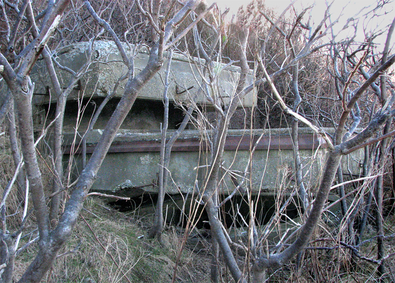
English: Photo (from 2010) looks SW at the two-level coincidence range finder (CRF) station of Battery Basinger, a dual 3-inch gun emplacement on the north shore of Long Island in Boston Harbor, part of Fort Strong and the Boston harbor defenses. This bunker was built in 1943 and is now obstructed by 67 years of brush and undergrowth.
The lower level had a floor area of roughly 10 x 9.5 feet, and its floor was about 3.5 feet below ground level. This level housed the CRF instrument, and had headroom for the operator of about 8 feet. The upper level vision slit was likely for an azimuth telescope, mounted on a steel pillar (the base of which still remains), so the bunker was likely manned by a two or three-man crew. Entry was by means of a steel door at the rear, now obstructed by earth that has slumped down the hill side. The view from this bunker was directly across the main harbor channel and towards Ft. Dawes on Deer Island (about 1,400 yards distant), now the Deer Island sewage treatment plant of the Massachusetts Water Resources Administration (MWRA). |
| Date | |
| Source | Own work |
| Author | Pgrig (talk) (Uploads) |
Summary
Photo (from 2010) looks SW at the two-level coincidence range finder (CRF) station of Battery Basinger, a dual 3-inch gun emplacement on the north shore of Long Island in Boston Harbor, part of Fort Strong and the Boston harbor defenses. This bunker was built in 1943 and is now obstructed by 67 years of brush and undergrowth.
The lower level had a floor area of roughly 10 x 9.5 feet, and its floor was about 3.5 feet below ground level. This level housed the CRF instrument, and had headroom for the operator of about 8 feet.
The upper level vision slit was likely for an azimuth telescope, mounted on a steel pillar (the base of which still remains), so the bunker was likely manned by a two or three-man crew.
Entry was by means of a steel door at the rear, now obstructed by earth that has slumped down the hill side. The view from this bunker was directly across the main harbor channel and towards Ft. Dawes on Deer Island (about 1,400 yards distant), now the Deer Island sewage treatment plant of the Massachusetts Water Resources Administration (MWRA).
Licensing
- You are free:
- to share – to copy, distribute and transmit the work
- to remix – to adapt the work
- Under the following conditions:
- attribution – You must give appropriate credit, provide a link to the license, and indicate if changes were made. You may do so in any reasonable manner, but not in any way that suggests the licensor endorses you or your use.
- share alike – If you remix, transform, or build upon the material, you must distribute your contributions under the same or compatible license as the original.
File history
Click on a date/time to view the file as it appeared at that time.
| Date/Time | Thumbnail | Dimensions | User | Comment | |
|---|---|---|---|---|---|
| current | 12:02, 3 July 2010 | | 800 × 575 (306 KB) | Pgrig | Photo (from 2010) looks SW at the two-level coincidence range finder (CRF) station of Battery Basinger, a dual 3-inch gun emplacement on the north shore of Long Island in Boston Harbor, part of Fort Strong and the Boston harbor defenses. This bunker was b |