
File:Bassin de l'Authie-fr.svg

Size of this PNG preview of this SVG file: 800 × 461 pixels. Other resolutions: 320 × 184 pixels | 640 × 369 pixels | 1,024 × 590 pixels | 1,280 × 738 pixels | 2,560 × 1,476 pixels | 1,060 × 611 pixels.
Original file (SVG file, nominally 1,060 × 611 pixels, file size: 1.14 MB)
| This is a file from the Wikimedia Commons. Information from its description page there is shown below. Commons is a freely licensed media file repository. You can help. |
| Description |
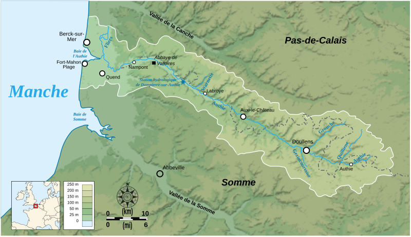
English: Map showing the drainage basin of the Authie river, Picardie, France. Français : Carte du bassin versant de l'Authie, Picardie, France. |
||
| Date | |||
| Source |
Data sources:
Softwares used: Others:
|
||
| Author | Bourrichon | ||
| Permission (Reusing this file) |
This file is licensed under the Creative Commons Attribution-Share Alike 3.0 Unported license.
|


|
This SVG file contains embedded text that can be translated into your language, using any capable SVG editor, text editor or the SVG Translate tool. For more information see: About translating SVG files. |
This W3C-unspecified vector image was created with Inkscape .
File history
Click on a date/time to view the file as it appeared at that time.
| Date/Time | Thumbnail | Dimensions | User | Comment | |
|---|---|---|---|---|---|
| current | 18:54, 22 February 2008 | | 1,060 × 611 (1.14 MB) | Bourrichon | correction placement Abbeville + typo |
| 17:01, 22 February 2008 |  | 1,060 × 611 (1.43 MB) | Bourrichon | + taille toponymes et ajout des vallées de la Somme et de la Canche | |
| 01:37, 17 February 2008 |  | 1,060 × 611 (1.44 MB) | Bourrichon | Petites corrections (typo, cadre) | |
| 01:19, 17 February 2008 |  | 1,060 × 611 (1.14 MB) | Bourrichon | + incorporation correcte du bitmap dans le svg | |
| 00:07, 17 February 2008 |  | 1,060 × 611 (136 KB) | Bourrichon | + incorporation du fond bitmap dans le svg | |
| 00:01, 17 February 2008 |  | 1,060 × 611 (136 KB) | Bourrichon | {{Information |Description= {{en}}Map showing the drainage basin of the Authie river, between Picardie and Haute-Normandie, France. {{fr}}Carte du bassin versant de l'Authie, entre la Picardie et la Haute-Normandie, Fra |
File usage
The following pages on the English Wikipedia use this file (pages on other projects are not listed):
Global file usage
The following other wikis use this file:
- Usage on de.wikipedia.org
- Usage on es.wikipedia.org
- Usage on et.wikipedia.org
- Usage on fr.wikipedia.org
- Usage on it.wikipedia.org
- Usage on nn.wikipedia.org
- Usage on pcd.wikipedia.org
- Usage on pl.wikipedia.org
- Usage on ru.wikipedia.org
- Usage on sr.wikipedia.org
- Usage on www.wikidata.org
- Usage on zh.wikipedia.org