
File:Battersea Park railway station MMB 24 377XXX 377445 377453 455806.jpg

Size of this preview: 800 × 481 pixels. Other resolutions: 320 × 193 pixels | 640 × 385 pixels | 1,024 × 616 pixels | 1,280 × 770 pixels | 2,560 × 1,540 pixels | 3,810 × 2,292 pixels.
Original file (3,810 × 2,292 pixels, file size: 3.06 MB, MIME type: image/jpeg)
| This is a file from the Wikimedia Commons. Information from its description page there is shown below. Commons is a freely licensed media file repository. You can help. |
| Description |
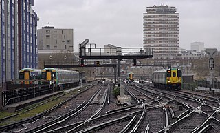
English: Looking north from Battersea Park railway station - Souther Class 377 "Electrostar" EMUs 377445 and a classmate sit in the sidings, 377453 speeds away from the camera and Class 455 EMU 455806 approaches. |
| Date | |
| Source | Own work by mattbuck. |
| Author | mattbuck (category) |
| Permission (Reusing this file) |
This file is licensed under the Creative Commons Attribution-Share Alike 2.0 Generic license.
This file is licensed under the Creative Commons Attribution-Share Alike 3.0 Unported license.
|
| Other versions | Uploaded to flickr. |
| Camera location | | View this and other nearby images on: OpenStreetMap |
|---|
This image has been assessed using the Quality image guidelines and is considered a Quality image.
|
File history
Click on a date/time to view the file as it appeared at that time.
| Date/Time | Thumbnail | Dimensions | User | Comment | |
|---|---|---|---|---|---|
| current | 15:36, 24 September 2012 | | 3,810 × 2,292 (3.06 MB) | Mattbuck | fix CAs |
| 02:26, 31 August 2012 |  | 3,810 × 2,292 (3.1 MB) | File Upload Bot (Magnus Manske) | Transferred from Flickr by User:mattbuck using flickr2commons |
File usage
The following pages on the English Wikipedia use this file (pages on other projects are not listed):