
File:Battle of Hasakah.svg

Size of this PNG preview of this SVG file: 800 × 555 pixels. Other resolutions: 320 × 222 pixels | 640 × 444 pixels | 1,024 × 710 pixels | 1,280 × 887 pixels | 2,560 × 1,775 pixels | 2,999 × 2,079 pixels.
Original file (SVG file, nominally 2,999 × 2,079 pixels, file size: 2.5 MB)
| This is a file from the Wikimedia Commons. Information from its description page there is shown below. Commons is a freely licensed media file repository. You can help. |
Summary
| Description |
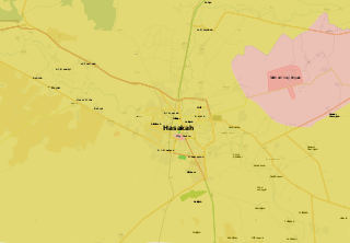
Bahasa Indonesia: Dikuasai oleh Angkatan Bersenjata Suriah
Dikuasai oleh Angkatan Kurdi Bosanski: Pod kontrolom Vladinih snaga
Pod kontrolom Kurda Català: Controlat pel govern
Controlat pels kurds Čeština: Pod kontrolou syrské vlády
Pod kontrolou syrské opozice Dansk: Kontrolleret af pro-Assad-styrker
Kontrolleret af syriske kurdere Deutsch: Von pro-Assad Kräften kontrolliert
Von kurdischen Kräften kontrolliert Español: Zonas controladas por el Gobierno Sirio
Zonas controladas por el Kurdistán Sirio (Rojava) Français : Zones sous contrôle pro-Assad
Zones sous contrôle kurde Hrvatski: Pod kontrolom Assadovih snaga
Pod kontolom Kurda Italiano: Zone sotto il controllo di forze Pro-Assad
Zone sotto controllo curdo Kurdî: سوپای ڕژێم
هێزه كوردیهكان Magyar: A szíriai hadsereg ellenőrzése alatt
A szíriai kurdok ellenőrzése alatt Polski: Tereny kontrolowane przez Siły Zbrojne Syrii
Tereny kontrolowane przez Powszechne Jednostki Ochrony (siły Kurdów) Português: Zonas controladas por forças pro-Assad
Zonas controladas por forças kurdas Română: Zone controlate de forțele pro-Assad
Zone controlate de forțele kurde Shqip: E kontrolluar nga forcat e Assadit
E kontrolluar nga forcat Kurde Slovenščina: Pod nadzorom sirijske vlade
Pod nadzorom sirijske opozicije Tiếng Việt: Kiểm soát bởi lực lượng thân Assad
Kiểm soát bởi lực lượng người Kurd Türkçe: Rejim güçlerinin kontrolünde
Kürt güçlerin kontrolünde Български: Под контрол на правителствените сили
Под контрол на кюрдските милиции Русский: Контролируются правительственными силами
Контролируются курдскими силами Српски / srpski: Под контролом Асадових снага
Под контролом Курда Українська: Контролюється владою Сирії
Контролюється курдами Հայերեն : Կառավարվում է Սիրիական կառավարական ուժերի կողմից
Կառավարվում է քրդերի կողմից संस्कृतम् : असदसमर्थक सेनानाम् नियन्त्रणे क्षेत्राः
कुर्द सेनानाम् नियन्त्रणे क्षेत्राः 한국어: 정부군 점령 지역
쿠르드족 점령 지역 中文: 巴沙尔·阿萨德政权控制的区域
库尔德人控制的区域 עברית : בשליטת כוחות נאמני אסד
בשליטת כוחות כורדים العربية : القوات الحكومية
القوات الكردية فارسی : در دست ارتش سوریه
در دست نیروهای کرد |
||||
| Date | |||||
| Source | Own work. Version 1 based on map by @archicivilian seen here, and that by Cedric Labrousse seen here. | ||||
| Author | MrPenguin20 | ||||
| Other versions |
|


.svg)

.png)


.svg)


.svg)


_Territory_Change_2014-2016.gif)

_(within_Northern_Syria).svg)


.png)
.svg)


_map.png)
.svg)


.svg)


Licensing
| This work contains information from OpenStreetMap, which is made available under the Open Database License (ODbL).
The ODbL does not require any particular license for maps produced from ODbL data. Prior to 1 August 2020, map tiles produced by the OpenStreetMap Foundation were licensed under the CC-BY-SA-2.0 license. Maps produced by other people may be subject to other licences. |
I, the copyright holder of this work, hereby publish it under the following license:
This file is licensed under the Creative Commons Attribution-Share Alike 3.0 Unported license.
- You are free:
- to share – to copy, distribute and transmit the work
- to remix – to adapt the work
- Under the following conditions:
- attribution – You must give appropriate credit, provide a link to the license, and indicate if changes were made. You may do so in any reasonable manner, but not in any way that suggests the licensor endorses you or your use.
- share alike – If you remix, transform, or build upon the material, you must distribute your contributions under the same or compatible license as the original.
File history
Click on a date/time to view the file as it appeared at that time.
| Date/Time | Thumbnail | Dimensions | User | Comment | |
|---|---|---|---|---|---|
| current | 09:12, 11 June 2017 | | 2,999 × 2,079 (2.5 MB) | Kami888 | 2017 |
| 15:35, 23 August 2016 |  | 2,999 × 2,079 (2.5 MB) | Semsûrî | https://twitter.com/sayed_ridha/status/768082029464268800 | |
| 02:26, 7 November 2015 |  | 2,999 × 2,079 (2.51 MB) | AlAboud83 | ypg advance http://www.hawarnews.com/%D8%A7%D8%B4%D8%AA%D8%A8%D8%A7%D9%83%D8%A7%D8%AA-%D9%82%D9%88%D9%8A%D8%A9-%D9%81%D9%8A-%D9%82%D8%B1%D9%8A%D8%A9-%D8%AF%D8%A7%D9%88%D9%88%D8%AF%D9%8A%D8%A9-%D8%B9%D8%A7%D8%AC%D9%84/ | |
| 21:20, 4 November 2015 |  | 2,999 × 2,079 (2.51 MB) | AlAboud83 | Humar Sharqiyah via http://www.hawarnews.com/%D8%AA%D8%AD%D8%B1%D9%8A%D8%B1-6-%D9%82%D8%B1%D9%89-%D9%88%D9%85%D9%82%D8%AA%D9%84-13-%D9%85%D8%B1%D8%AA%D8%B2%D9%82%D8%A9/ | |
| 21:57, 17 August 2015 |  | 2,999 × 2,079 (2.52 MB) | AlAboud83 | updated it,YPG and SAA has taken full control over the city | |
| 19:04, 28 July 2015 |  | 2,999 × 2,079 (2.53 MB) | Tan Khaerr | Reverted to version as of 17:43, 26 July 2015 | |
| 19:03, 28 July 2015 |  | 2,999 × 2,079 (2.59 MB) | Tan Khaerr | Reverted to version as of 02:47, 9 July 2015 | |
| 17:43, 26 July 2015 |  | 2,999 × 2,079 (2.53 MB) | AlAboud83 | Via SOHR and https://twitter.com/sylezjusz/status/625331088462901248 | |
| 02:47, 9 July 2015 |  | 2,999 × 2,079 (2.59 MB) | MrPenguin20 | Updated as according to Cizire Canton. Added lines to demarcate previous frontlines (give impression of changing land) | |
| 02:04, 29 June 2015 |  | 2,999 × 2,079 (2.6 MB) | Kami888 | changes based on maps by deSyracuse, Hassan Ridha, and CizireCanton |
File usage
The following pages on the English Wikipedia use this file (pages on other projects are not listed):
Global file usage
The following other wikis use this file:
- Usage on ar.wikipedia.org
- Usage on az.wikipedia.org
- Usage on be.wikipedia.org
- Usage on es.wikipedia.org
- Usage on fo.wikipedia.org
- Usage on hu.wikipedia.org
- Usage on id.wikipedia.org
- Usage on ru.wikipedia.org
- Usage on sh.wikipedia.org
- Usage on sr.wikipedia.org
- Usage on www.wikidata.org