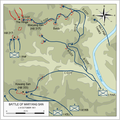
File:Battle of Maryang San 2-8 October 1951.png

Page contents not supported in other languages.
This is a file from the Wikimedia Commons
From Wikipedia, the free encyclopedia

Battle_of_Maryang_San_2-8_October_1951.png(574 × 572 pixels, file size: 118 KB, MIME type: image/png)

Summary

Description
English: Map illustrating the Battle of Maryang San, which took place 2–8 October 1951.
Date
Source

Self created from maps of battle in:

  • O'Neill, Robert (1985) Australia in the Korean War 1950–53: Combat Operations, Volume II, Canberra, Australian Capital Territory: Australian War Memorial ISBN: 978-0-642-04330-6. ;
  • Breen, Bob (1994) The Battle of Maryang San: 3rd Battalion, the Royal Australian Regiment, 2–8 October 1951 (Second ed.), Georges Heights, New South Wales: Headquarters Training Command, Australian Army ISBN: 0-642-21308-9. ; and
  • Maryang San "Operation Commando" 5-8 October 1951. Out In the Cold: Australia's Involvement in the Korean War. Australian War Memorial. Retrieved on 7 June 2016.
Author Anotherclown

Licensing

Anotherclown at English Wikipedia, the copyright holder of this work, hereby publishes it under the following license:
w:en:Creative Commons
attribution share alike
This file is licensed under the Creative Commons Attribution-Share Alike 3.0 Unported license.
You are free:
  • to share – to copy, distribute and transmit the work
  • to remix – to adapt the work
Under the following conditions:
  • attribution – You must give appropriate credit, provide a link to the license, and indicate if changes were made. You may do so in any reasonable manner, but not in any way that suggests the licensor endorses you or your use.
  • share alike – If you remix, transform, or build upon the material, you must distribute your contributions under the same or compatible license as the original.

Captions

Add a one-line explanation of what this file represents

Items portrayed in this file

depicts

7 June 2016

image/png

3c988bcb458f3c2a293477d0b8526b2c40f8a747

120,734 byte

572 pixel

574 pixel

File history

Click on a date/time to view the file as it appeared at that time.

Date/TimeThumbnailDimensionsUserComment
current05:53, 16 September 2016Thumbnail for version as of 05:53, 16 September 2016574 × 572 (118 KB)AnotherclownEnlarge a little
21:54, 11 September 2016Thumbnail for version as of 21:54, 11 September 2016514 × 514 (101 KB)AnotherclownImprove definition of river, changes to course
10:27, 14 June 2016Thumbnail for version as of 10:27, 14 June 2016514 × 514 (132 KB)AnotherclownCorrect colour of another feature missed in previous revision
03:53, 14 June 2016Thumbnail for version as of 03:53, 14 June 2016514 × 514 (132 KB)AnotherclownInvert colours for contours, solid line for unit movt arrows, other minor fixes
23:20, 7 June 2016Thumbnail for version as of 23:20, 7 June 2016514 × 513 (95 KB)AnotherclownCorrections and colour changes for contrast
10:14, 7 June 2016Thumbnail for version as of 10:14, 7 June 2016513 × 513 (98 KB)Anotherclown== {{int:filedesc}} == {{Information |Description={{en|Map illustrating the Battle of Maryang San, which took place 2–8 October 1951.}} |Source=Self created from map of battle in {{cite book|last=O'Neill |first=Rob...
The following pages on the English Wikipedia use this file (pages on other projects are not listed):

Global file usage

The following other wikis use this file:

Metadata