
File:Bevölkerungsentwicklung Ahrensfelde.svg

Size of this PNG preview of this SVG file: 800 × 559 pixels. Other resolutions: 320 × 224 pixels | 640 × 448 pixels | 1,024 × 716 pixels | 1,280 × 895 pixels | 2,560 × 1,790 pixels | 1,011 × 707 pixels.
Original file (SVG file, nominally 1,011 × 707 pixels, file size: 272 KB)
| This is a file from the Wikimedia Commons. Information from its description page there is shown below. Commons is a freely licensed media file repository. You can help. |
 This media file has been nominated for deletion since 12 May 2024. To discuss it, please visit the nomination page.
Do not remove this tag until the deletion nomination is closed. Reason for the nomination: These graphs make zero sense due to the break in the line and overlap between them in 2010. So they should be deleted as OOS due to the inaccurate data. Or did the population completely die off while being replaced to about the same level at exactly the same time?
| |||
| |||
Summary
| Description |
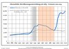
Deutsch: Bevölkerungsentwicklung in den heutigen Grenzen von Ahrensfelde, Landkreis Barnim, Land Brandenburg, Deutschland
Blaue Linie: Bevölkerung -- Punktierte Linie: Vergleich mit der Entwicklung Brandenburgs Grauer Hintergrund: Zeit der Nazi-Herrschaft -- Roter Hintergrund: DDR-Zeit English: Population development within the current boundaries of Ahrensfelde, Barnim district, Brandenburg state, Germany
Blue line: Population -- Dotted line: Comparison to population development of Brandenburg state Grey background: Time of nazi rule -- Red background: Time of communist rule 中文:人口发展在今天的阿伦斯费尔德边界内,巴尔尼姆县,勃兰登堡州,德国
蓝线:人口 -- 虚线:与勃兰登堡州发展的比较 灰色背景:纳粹统治时期 -- 红色背景:德意志民主共和国时期 Español: Desarrollo de la población en los actuales límites de Ahrensfelde, distrito de Barnim, estado de Brandenburg, Alemania
Línea azul: Habitantes -- Línea de puntos: Comparación con el desarrollo de Brandenburgo Fondo gris: Período del gobierno nazi -- Fondo Rojo: Época communista Français : Développement de la population dans les limites actuelles de Ahrensfelde, arrondissement de Barnim, Land de Brandebourg, Allemagne
Ligne bleue: Population -- Ligne pointillé: Comparaison avec le développement de Brandebourg Fond gris: Période du régime nazie -- Fond rouge: Période du régime communiste Italiano: Sviluppo della popolazione entro gli attuali confini de Ahrensfelde, circondario de Barnim, stato federato de Brandeburgo, Germania
Linea Blu: Popolazione -- Linea puntata: Confronto dello sviluppo della popolazione dello stato del Brandenburgo Sfondo grigio: Ai tempi del governo nazista -- Sfondo rosso: Al tempo del governo comunista Nederlands: Ontwikkeling van de bevolking binnen de huidige grenzen van Ahrensfelde, landkreis Barnim, deelstaat Brandenburg, Duitsland
Blauwe lijn: Bevolking -- Stippellijn: Vergelijking van de ontwikkeling van de bevolking van de deelstaat Brandenburg Grijze achtergrond: tijdens de nazi-regering -- Rode achtergrond: tijdens de communistische regering Polski: Rozwój ludności w obecnych granicach dla Ahrensfelde, powiat Barnim, kraj Brandenburgia, Niemcy
Niebieska linia: Populacja -- Linia przerywana: Porównanie z rozwoju Brandenburgii Szare tło: Okres hitlerowców -- Czerwone tło: Okres rządów komunistycznych Svenska: Befolkningsutvecklingen i de nuvarande gränserna för Ahrensfelde, landkreis Barnim, delstaten Brandenburg, Tyskland Blå linje: Befolkning -- Prickade linjen: Jämförelse med utvecklingen av Brandenburg Grå bakgrund: Period av Nazi styre -- Röd bakgrund: Period av kommunistiskt styre |
| Date | between 29 April 2012 and 19 June 2021 |
| Source |
Own work based on: Population Projection Brandenburg at Wikimedia Commons |
| Author | Hans G. Oberlack |
| Permission (Reusing this file) |
I, the copyright holder of this work, hereby publish it under the following license: This file is licensed under the Creative Commons Attribution-Share Alike 3.0 Unported license.
|
| Latest population data | 2020 |
| Object location | | View this and other nearby images on: OpenStreetMap |
|---|
File history
Click on a date/time to view the file as it appeared at that time.
| Date/Time | Thumbnail | Dimensions | User | Comment | |
|---|---|---|---|---|---|
| current | 04:43, 20 January 2024 | | 1,011 × 707 (272 KB) | Zhing'za zï Ïnin | fixed broken text spacing/Der unterbrochene Textabstand wurde behoben |
| 04:41, 20 January 2024 |  | 1,011 × 707 (41 KB) | Zhing'za zï Ïnin | {{Information |Description= {{de|1=Bevölkerungsentwicklung in den heutigen Grenzen von '''Ahrensfelde''', Landkreis Barnim, Land Brandenburg, Deutschland<br>Blaue Linie: Bevölkerung -- Punktierte Linie: Vergleich mit der Entwicklung Brandenburgs <br>Grauer Hintergrund: Zeit der Nazi-Herrschaft -- Roter Hintergrund: DDR-Zeit}} {{en|1=Population development within the current boundaries of '''Ahrensfelde''', Barnim district, Brandenburg state, Germany<br>Blue line: Population -- Dotted line: Co... |
File usage
The following pages on the English Wikipedia use this file (pages on other projects are not listed):