
File:Birthplace of Army Chemical Corps, American University.jpg
Birthplace_of_Army_Chemical_Corps,_American_University.jpg (600 × 437 pixels, file size: 127 KB, MIME type: image/jpeg)
| This is a file from the Wikimedia Commons. Information from its description page there is shown below. Commons is a freely licensed media file repository. You can help. |
Summary
| Description |
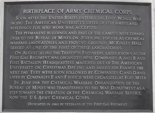
English: BIRTHPLACE OF ARMY CHEMICAL CORPS
SOON AFTER THE UNITED STATES ENTERED THE FIRST WORLD WAR IN 1917. THE AMERICAN UNIVERSITY'S OFFER OF ITS CAMPUS AND BUILDINGS FOR WAR WORK WAS ACCEPTED. THE PERMANENT BUILDINGS AND PART OF THE CAMPUS WERE TURNED OVER TO THE BUREAU OF MINE ON JULY 6, 1917. FOR USE AS CHEMICAL WARFARE LABORATORIES AND PROVING GROUNDS. MCKINLEY HALL SERVED AS ONE OF THE FIRST OF THESE LABORATORIES. ON AUGUST 30, 1917, THE THIRTIETH ENGINEERS, LATER KNOWN AS THE FIRST GAS REGIMENT WAS ORGANIZED HERE. COMPANIES A AND B AND FIRST BATTALION HEADQUARTERS MARCHED OUT OF THE AMERICAN UNIVERSITY ON CHRISTMAS DAY 1917, AND SAILED FOR FRANCE THE NEXT DAY. THEY WERE SOON FOLLOWED BY COMPANIES C AND D, AND LATER BY COMPANIES E AND F WHICH WERE ORGANIZED AT FORT MYER. IN JUNE 1918, THE CHEMICAL WARFARE ORGANIZATION OF THE BUREAU OF MINES WAS TRANSFERRED TO THE WAR DEPARTMENT AS A STEP TOWARD THE CREATION OF THE CHEMICAL WARFARE SERVICE, NOW THE U.S. ARMY CHEMICAL CORPS. DEDICATED IN 1960 BY VETERANS OF THE FIRST GAS REGIMENT |
| Date | Taken on 27 March 2018 |
| Source | American University |
| Author | American University |
| Permission (Reusing this file) |
This file is licensed under the Creative Commons Attribution-Share Alike 4.0 International license.
|
| Other versions |
|

| Camera location | | View this and other nearby images on: OpenStreetMap |
|---|
File history
Click on a date/time to view the file as it appeared at that time.
| Date/Time | Thumbnail | Dimensions | User | Comment | |
|---|---|---|---|---|---|
| current | 17:55, 26 April 2018 | | 600 × 437 (127 KB) | KAMorgan97 | User created page with UploadWizard |