
File:Bishop Bridge Norwich - geograph.org.uk - 1339168.jpg
No higher resolution available.
Bishop_Bridge_Norwich_-_geograph.org.uk_-_1339168.jpg (640 × 428 pixels, file size: 79 KB, MIME type: image/jpeg)
| This is a file from the Wikimedia Commons. Information from its description page there is shown below. Commons is a freely licensed media file repository. You can help. |
Summary
| Description |
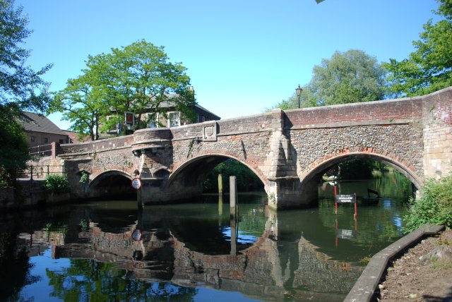
English: Bishop Bridge Norwich Bishop Bridge is the only surviving medieval bridge in the city. It was built in 1340, one of the oldest bridges still in use in England. A fortified gatehouse stood on the bridge until the 18th century, and the semi-circular projection you can see today is part of its outer turrets. In 1549 it became a battlefield, when Robert Ketts rebels fought royal troops. The rebels overcame the defenders, and ran amok through Norwich. You can see the arms of the city a lion and castle carved over a central arch; the Red Lion pub probably derives its name from this. Originally owned by monks, the prior was allowed to build houses on the bridge but had to allow access for people and their horses beside the arches. In 1393 it was handed over to the city. |
| Date | |
| Source | From geograph.org.uk |
| Author | Craig Tuck |
| Attribution (required by the license) | Craig Tuck / Bishop Bridge Norwich / |
| Camera location | | View this and other nearby images on: OpenStreetMap |
|---|
_heading:337.00&language=en)
| Object location | | View this and other nearby images on: OpenStreetMap |
|---|
_heading:337.00&language=en)
Licensing

|
This image was taken from the Geograph project collection. See this photograph's page on the Geograph website for the photographer's contact details. The copyright on this image is owned by Craig Tuck and is licensed for reuse under the Creative Commons Attribution-ShareAlike 2.0 license.
|
This file is licensed under the Creative Commons Attribution-Share Alike 2.0 Generic license.
Attribution: Craig Tuck
- You are free:
- to share – to copy, distribute and transmit the work
- to remix – to adapt the work
- Under the following conditions:
- attribution – You must give appropriate credit, provide a link to the license, and indicate if changes were made. You may do so in any reasonable manner, but not in any way that suggests the licensor endorses you or your use.
- share alike – If you remix, transform, or build upon the material, you must distribute your contributions under the same or compatible license as the original.
File history
Click on a date/time to view the file as it appeared at that time.
| Date/Time | Thumbnail | Dimensions | User | Comment | |
|---|---|---|---|---|---|
| current | 00:37, 28 February 2011 | | 640 × 428 (79 KB) | GeographBot | == {{int:filedesc}} == {{Information |description={{en|1=Bishop Bridge Norwich Bishop Bridge is the only surviving medieval bridge in the city. It was built in 1340, one of the oldest bridges still in use in England. A fortified gatehouse stood on the bri |
File usage
The following pages on the English Wikipedia use this file (pages on other projects are not listed):