
File:Bosque Boqueron 2018.jpg

Size of this preview: 800 × 450 pixels. Other resolutions: 320 × 180 pixels | 640 × 360 pixels | 1,024 × 576 pixels | 1,280 × 720 pixels | 2,560 × 1,440 pixels | 3,840 × 2,160 pixels.
Original file (3,840 × 2,160 pixels, file size: 2.22 MB, MIME type: image/jpeg)
| This is a file from the Wikimedia Commons. Information from its description page there is shown below. Commons is a freely licensed media file repository. You can help. |
Summary
| Description |
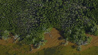
English: G-LiHT captured this image of a coastal forest near the village of Boquerón on the southwest tip of Puerto Rico on April 26, 2018, seven months after Hurricane Maria struck the island. The brown organic matter in the water appears to be the remains of an algal bloom. Disturbances such as storms can send nutrients, such as nitrogen from leaves and soil, from the forest to the coast, resulting in algal blooms and other marine vegetative growth. Credits: NASA
NASA image use policy. NASA Goddard Space Flight Center enables NASA’s mission through four scientific endeavors: Earth Science, Heliophysics, Solar System Exploration, and Astrophysics. Goddard plays a leading role in NASA’s accomplishments by contributing compelling scientific knowledge to advance the Agency’s mission. Follow us on Twitter Like us on Facebook Find us on Instagram</b |
| Date | |
| Source | https://www.flickr.com/photos/35278629@N08/42603894074/ |
| Author | NASA Goddard Space Flight Center |
| Camera location | | View this and other nearby images on: OpenStreetMap |
|---|
Licensing
This file is licensed under the Creative Commons Attribution 2.0 Generic license.
- You are free:
- to share – to copy, distribute and transmit the work
- to remix – to adapt the work
- Under the following conditions:
- attribution – You must give appropriate credit, provide a link to the license, and indicate if changes were made. You may do so in any reasonable manner, but not in any way that suggests the licensor endorses you or your use.
| This image was originally posted to Flickr by NASA Goddard Space Flight Center at https://flickr.com/photos/35278629@N08/42603894074. It was reviewed on 6 April 2020 by FlickreviewR 2 and was confirmed to be licensed under the terms of the cc-by-2.0. |
File history
Click on a date/time to view the file as it appeared at that time.
| Date/Time | Thumbnail | Dimensions | User | Comment | |
|---|---|---|---|---|---|
| current | 00:46, 6 April 2020 | | 3,840 × 2,160 (2.22 MB) | Killarnee | Uploaded a work by NASA Goddard Space Flight Center from https://www.flickr.com/photos/35278629@N08/42603894074/ with UploadWizard |
File usage
The following pages on the English Wikipedia use this file (pages on other projects are not listed):