
File:Brandenburg-Preussen-1701-1806 ohne Westen.png

Size of this preview: 736 × 600 pixels. Other resolutions: 295 × 240 pixels | 589 × 480 pixels | 1,020 × 831 pixels.
Original file (1,020 × 831 pixels, file size: 80 KB, MIME type: image/png)
| This is a file from the Wikimedia Commons. Information from its description page there is shown below. Commons is a freely licensed media file repository. You can help. |
Summary
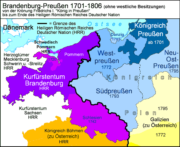
| Description | Map of Brandenburg-Prussia 1701-1806 without western territories; correction of HilmarHansWerner's version |
| Date | |
| Source | HilmarHansWerner 2008-10-25 |
| Author | Ulamm |
| Other versions | File:Brandenburg-preussen-1701-1806.png |
Licensing
I, the copyright holder of this work, hereby publish it under the following licenses:
This file is licensed under the Creative Commons Attribution-Share Alike 3.0 Unported license.
- You are free:
- to share – to copy, distribute and transmit the work
- to remix – to adapt the work
- Under the following conditions:
- attribution – You must give appropriate credit, provide a link to the license, and indicate if changes were made. You may do so in any reasonable manner, but not in any way that suggests the licensor endorses you or your use.
- share alike – If you remix, transform, or build upon the material, you must distribute your contributions under the same or compatible license as the original.

|
Permission is granted to copy, distribute and/or modify this document under the terms of the GNU Free Documentation License, Version 1.2 or any later version published by the Free Software Foundation; with no Invariant Sections, no Front-Cover Texts, and no Back-Cover Texts. A copy of the license is included in the section entitled GNU Free Documentation License. |
You may select the license of your choice.
File history
Click on a date/time to view the file as it appeared at that time.
| Date/Time | Thumbnail | Dimensions | User | Comment | |
|---|---|---|---|---|---|
| current | 12:35, 15 December 2012 | | 1,020 × 831 (80 KB) | Ulamm | minus Hobelspan ;-) |
| 12:30, 15 December 2012 |  | 1,020 × 831 (90 KB) | Ulamm | + Vorpommern-Stettin | |
| 11:40, 15 December 2012 |  | 1,020 × 831 (80 KB) | Ulamm | + correct coastline + Danzig + Swedish Pomorania | |
| 10:14, 14 December 2012 |  | 1,020 × 831 (72 KB) | Ulamm | == {{int:filedesc}} == {{Information |Description=Map of Brandenburg-Prussia 1701-1806 without western territories; correction of HilmarHansWerner's version |Source=HilmarHansWerner 2008-10-25 |Date=2012-12-15 |Author= [[User... |
File usage
The following pages on the English Wikipedia use this file (pages on other projects are not listed):
Global file usage
The following other wikis use this file:
- Usage on de.wikipedia.org
- Usage on hy.wikipedia.org
- Usage on pt.wikipedia.org
- Usage on ro.wikipedia.org
- Usage on ru.wikipedia.org