
File:California Gulch Rd, Colo.jpg

Size of this preview: 800 × 450 pixels. Other resolutions: 320 × 180 pixels | 640 × 360 pixels | 1,024 × 576 pixels | 1,280 × 720 pixels | 2,560 × 1,440 pixels | 3,968 × 2,232 pixels.
Original file (3,968 × 2,232 pixels, file size: 3.51 MB, MIME type: image/jpeg)
| This is a file from the Wikimedia Commons. Information from its description page there is shown below. Commons is a freely licensed media file repository. You can help. |
Summary
| Description |
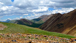
California Gulch Rd, Colo. This trail is absolutely beautiful from start to finish. Though it isn't a technically challenging trail it does follow very narrow shelf roads. All drivers will need to be very careful. You can start at either end. This means you can start at Animas Forks at the intersection of California Gulch, Cinnamon Pass and Engineer Pass, or you can start at Lake Como at the intersection of California Gulch, Poughkeepsie Gulch and Hurricane Pass. This trail connects a lot of trails. |
| Date | |
| Source |
|
| Author | robert thigpen from diboll, texas |
| Camera location | | View this and other nearby images on: OpenStreetMap |
|---|
Licensing
This file is licensed under the Creative Commons Attribution-Share Alike 2.0 Generic license.
- You are free:
- to share – to copy, distribute and transmit the work
- to remix – to adapt the work
- Under the following conditions:
- attribution – You must give appropriate credit, provide a link to the license, and indicate if changes were made. You may do so in any reasonable manner, but not in any way that suggests the licensor endorses you or your use.
- share alike – If you remix, transform, or build upon the material, you must distribute your contributions under the same or compatible license as the original.
| This image, originally posted to Flickr, was reviewed on February 12, 2011 by the administrator or reviewer File Upload Bot (Magnus Manske), who confirmed that it was available on Flickr under the stated license on that date. |
File history
Click on a date/time to view the file as it appeared at that time.
| Date/Time | Thumbnail | Dimensions | User | Comment | |
|---|---|---|---|---|---|
| current | 05:58, 12 February 2011 | | 3,968 × 2,232 (3.51 MB) | File Upload Bot (Magnus Manske) | {{Information |Description=This trail is absolutely beautiful from start to finish. Though it isn't a technically challenging trail it does follow very narrow shelf roads. All drivers will need to be very careful. You can start at either end. This means |
File usage
The following pages on the English Wikipedia use this file (pages on other projects are not listed):