
File:Capital Beltway Anacostia Freeway junction.jpg

Size of this preview: 800 × 600 pixels. Other resolutions: 320 × 240 pixels | 640 × 480 pixels | 1,024 × 768 pixels | 1,280 × 960 pixels | 2,560 × 1,920 pixels | 3,264 × 2,448 pixels.
Original file (3,264 × 2,448 pixels, file size: 3.26 MB, MIME type: image/jpeg)
| This is a file from the Wikimedia Commons. Information from its description page there is shown below. Commons is a freely licensed media file repository. You can help. |
Summary
| Description |
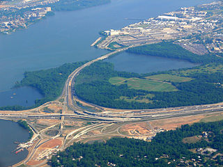
English: Junction of Capital Beltway I-95/I-495 and the southern terminus of Anacostia Freeway I-295; Potomac River; Oxon Hill Farm |
| Date | |
| Source | Self-photographed |
| Author | Photo: Andreas Praefcke |
| Camera location | | View this and other nearby images on: OpenStreetMap |
|---|
Licensing
| I, the copyright holder of this work, release this work into the public domain. This applies worldwide. In some countries this may not be legally possible; if so: I grant anyone the right to use this work for any purpose, without any conditions, unless such conditions are required by law. |
File history
Click on a date/time to view the file as it appeared at that time.
| Date/Time | Thumbnail | Dimensions | User | Comment | |
|---|---|---|---|---|---|
| current | 12:00, 13 June 2007 | | 3,264 × 2,448 (3.26 MB) | AndreasPraefcke | {{Information |Description= Junction of Capital Beltway I-95/I-495 and the southern terminus of Anacostia Freeway I-295; Potomac River; Oxon Hill Farm <br />[http://maps.google.com/maps?t=h&q=38.852222,-77.037778&ie=UTF8&ll=38.793196,-77.015491&spn=0.0311 |
File usage
The following pages on the English Wikipedia use this file (pages on other projects are not listed):
Global file usage
The following other wikis use this file:
- Usage on da.wikipedia.org
- Usage on es.wikipedia.org
- Usage on no.wikipedia.org
- Usage on www.wikidata.org
- Usage on zh.wikipedia.org