
File:Carolingian empire 814.svg

Size of this PNG preview of this SVG file: 619 × 599 pixels. Other resolutions: 248 × 240 pixels | 496 × 480 pixels | 793 × 768 pixels | 1,058 × 1,024 pixels | 2,116 × 2,048 pixels | 1,092 × 1,057 pixels.
Original file (SVG file, nominally 1,092 × 1,057 pixels, file size: 237 KB)
| This is a file from the Wikimedia Commons. Information from its description page there is shown below. Commons is a freely licensed media file repository. You can help. |
Summary
| Description |
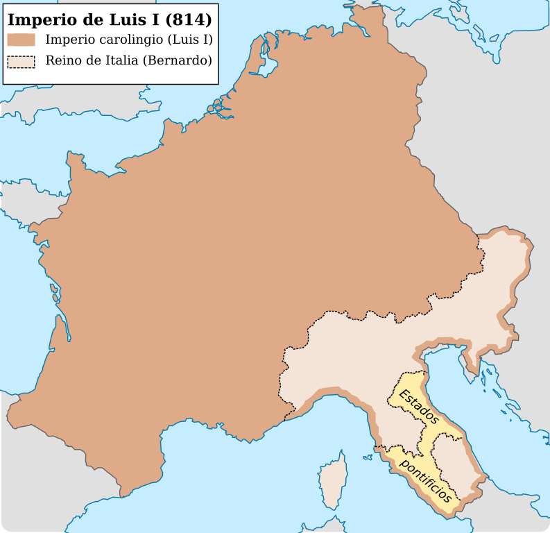
Español: Imperio carolingio al ascenso del emperador Luis I (814) |
| Date | |
| Source |
Own work
|
| Author | Trasamundo |
| Other versions |
|


Licensing
I, the copyright holder of this work, hereby publish it under the following licenses:

|
Permission is granted to copy, distribute and/or modify this document under the terms of the GNU Free Documentation License, Version 1.2 or any later version published by the Free Software Foundation; with no Invariant Sections, no Front-Cover Texts, and no Back-Cover Texts. A copy of the license is included in the section entitled GNU Free Documentation License. |
This file is licensed under the Creative Commons Attribution-Share Alike 3.0 Unported, 2.5 Generic, 2.0 Generic and 1.0 Generic license.
- You are free:
- to share – to copy, distribute and transmit the work
- to remix – to adapt the work
- Under the following conditions:
- attribution – You must give appropriate credit, provide a link to the license, and indicate if changes were made. You may do so in any reasonable manner, but not in any way that suggests the licensor endorses you or your use.
- share alike – If you remix, transform, or build upon the material, you must distribute your contributions under the same or compatible license as the original.
You may select the license of your choice.
File history
Click on a date/time to view the file as it appeared at that time.
| Date/Time | Thumbnail | Dimensions | User | Comment | |
|---|---|---|---|---|---|
| current | 12:01, 28 October 2021 | | 1,092 × 1,057 (237 KB) | Rowanwindwhistler | minor change in sea lines so hide them in the frame side |
| 11:59, 28 October 2021 |  | 1,092 × 1,057 (235 KB) | Rowanwindwhistler | Lighter colours, fake text added for better rendering in articles (real text is now hidden). | |
| 08:29, 4 May 2016 |  | 1,091 × 1,053 (185 KB) | Rowanwindwhistler | Softer colours, bigger font size | |
| 22:03, 22 April 2016 |  | 1,091 × 1,053 (185 KB) | Rowanwindwhistler | Cleaner shapes, some colours from https://en.wikipedia.org/wiki/Wikipedia:WikiProject_Maps/Conventions | |
| 18:24, 13 March 2010 |  | 1,091 × 1,053 (734 KB) | Trasamundo | {{Information |Description={{es|1=Imperio carolingio al ascenso del emperador Luis I (814)}} |Source={{own}} |Author=Trasamundo |Date=13 March 2010 |Permission= |other_versions= }} Category:Maps of the Carolingian Empire |
File usage
The following pages on the English Wikipedia use this file (pages on other projects are not listed):
Global file usage
The following other wikis use this file:
- Usage on ast.wikipedia.org
- Usage on es.wikipedia.org
- Usage on gl.wikipedia.org
- Usage on it.wikipedia.org
- Usage on zh.wikipedia.org