
File:Carte des Estats de Suede, de Dannemarq, et de Pologne; sur la Mer Baltique.jpg

Size of this preview: 483 × 599 pixels. Other resolutions: 193 × 240 pixels | 387 × 480 pixels | 619 × 768 pixels | 825 × 1,024 pixels | 1,650 × 2,048 pixels | 2,882 × 3,576 pixels.
Original file (2,882 × 3,576 pixels, file size: 5.12 MB, MIME type: image/jpeg)
| This is a file from the Wikimedia Commons. Information from its description page there is shown below. Commons is a freely licensed media file repository. You can help. |
Summary
| Description |
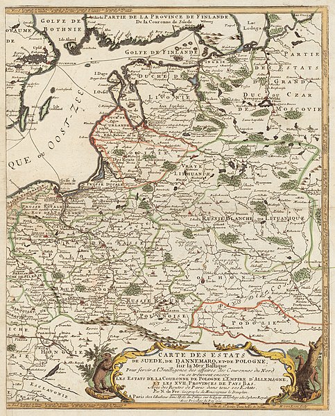
Carte des Estats de Suede, de Dannemarq, et de Pologne; sur la Mer Baltique English: Published in Paris by Nicolas de Fer in 1700. Copper engraving, ca 1:4 200 000, 35 x 43 cm.
The original map consists of two parts; the present is an Eastern part. Українська: Карта Польщі (Речі Посполитої до якої входила Волинь, Поділля) та Прибалтики видана в Парижі в 1700 році.
Масштаб 1:4 200 000, 35 x 43 см. Оригінальна мапа складається з двох частин. Lietuvių: Lietuvos Didžiosios kunigaikštystės žemėlapis su pažymėta Tikrąja Lietuva (Lithuania Proper) |
||||
| Date | |||||
| Source | http://www.nlib.ee/html/digi/maps/kaart00280.jpg, original in the National Library Cartography Collection | ||||
| Author | Nicolas de Fer (1646-1720) | ||||
| Permission (Reusing this file) |
|
||||
| Other versions | |||||
_is_clearly_separated_with_a_green_line_from_Samogitia_(Samogitie),_and_the_Belarusian_territories_of_the_Grand_Duchy_of_Lithuania_(Russie_Blanche_ou_Lituanique).jpg)
File history
Click on a date/time to view the file as it appeared at that time.
| Date/Time | Thumbnail | Dimensions | User | Comment | |
|---|---|---|---|---|---|
| current | 04:56, 8 July 2008 | | 2,882 × 3,576 (5.12 MB) | Albert Krantz | {{Information |Description=? |Source=? |Author=? |Date= |Permission= |other_versions= }} {{ImageUpload|full}} |
File usage
The following pages on the English Wikipedia use this file (pages on other projects are not listed):
Global file usage
The following other wikis use this file:
- Usage on bg.wikipedia.org
- Usage on cs.wikipedia.org
- Usage on et.wikipedia.org
- Usage on lt.wikipedia.org
- Usage on lt.wikibooks.org
- Usage on lv.wikipedia.org
- Usage on uk.wikipedia.org